All Activity
- Past hour
-
Wet.
-
Models backing off, was hoping for some damage
-
Only 0.62" total here. That's fine as long as it doesn't go dry for a week. Congrats to those in the moderate-severe drought area. This event at least put a significant dent in it.
-

2024-2025 La Nina
40/70 Benchmark replied to George001's topic in Weather Forecasting and Discussion
Makes sense given CC leads to increased mositure, this elevating humidity capping heat....its the HI that will be morbid. -
Lost track of total rainfall, since midnight .12"/ low 48F
-
Overnight batch was impressive. Woke me up out of a dead sleep.
-
Not sure. But the Euro is usually more accurate with the summer than the winter forecast for us. Probably due to less moving parts in the summer so to speak. The reason it may be wet for us is that there are two ridge centers showing up for the summer forecast. One east of New England and another out West. So perhaps the model is trying to show a weakness in the ridge where there could be some moisture pooling. We’ll see if it has a clue.

-
Pretty meh at BDR
.thumb.png.30196dace342082fab11cd4859a4e2c5.png)
-
2024-2025 La Nina
40/70 Benchmark replied to George001's topic in Weather Forecasting and Discussion
Doubt that....humidity is increasing, which while very uncomfortable, caps how warm it can get...HI absolutely may get that high. -
1980 summer here we come :-)
-
The Euro might be wrong about that third one, the NWS has us going into a drier and warmer pattern starting on May 11th (Mothers Day) for an extended period.
-

E PA/NJ/DE Spring 2025 Obs/Discussion
JTA66 replied to PhiEaglesfan712's topic in Philadelphia Region
Picked up .90” early this morning. -
honestly impressed that we've avoided one of these global death ridges for so long, our time will come and we should probably savor the comfort
-
But the X link Tony posted indicated a dry summer for us? Why are these cutoffs becoming much more common, is it because of climate change too? Back in the 80s and 90s our Mays were much warmer and drier and we didn't see cutoffs after April.
-
Drier and Warmer weather for an extended period likely to arrive just in time for Mother's Day (May 11th).
-
.thumb.jpg.6a4895b2a43f87359e4e7d04a6fa0d14.jpg)
Central PA Spring 2025
Yardstickgozinya replied to canderson's topic in Upstate New York/Pennsylvania
Normally I wouldn't post these on marginal days like today and yesterday but given the slow and training nature of this system and drought conditions I have decided to. Keep I'm mind that both yesterday and today have less then a 5% risk of anyone in CPA seeing severe weatherat there local. ...Northern Mid-Atlantic... A mid-level low will move northeastward across the Ohio Valley today, as a front advances eastward through the central Appalachians into the Mid-Atlantic. An axis of low-level moisture will be located ahead of the front with surface dewpoints in the 50s F. As surface temperatures heat up during the day, weak instability is forecast to develop along and near this moist axis. Low-level convergence and large-scale ascent associated with the mid-level system will likely support isolated to scattered thunderstorm development. In addition to the weak instability, RAP forecast soundings have moderate deep-layer shear in the Mid-Atlantic with steep low-level lapse rates exceeding 8 C/km. This could support a marginal wind-damage threat during the afternoon, with the threat eventually transitioning eastward into the Hudson River Valley.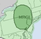
-
early summery period may have been delayed, but denied. I'm all in.
-
The only two summers in the 1970s that jump out at me for heat were 1973 and 1977. Before then, our historically hot summers occurred in an 11 year cycle (1944, 1955, 1966.) 1977 still has our hottest two week stretch on record. Of course the 1980s and 1990s were much hotter, 1980 got things started with a historic CONUS heatwave. If I remember correctly the following summers were very hot: 1980, 1983, 1988, 1991, 1993, 1995, 1999, 2002, 2010-2013 Actually that 11 year solar cycle has still prevailed for summer heat, with a few other years thrown in. Map these years for summer heat: 1933, 1944, 1955, 1966, 1977, 1988, 1999, 2010. I think that pattern was broken in 2021 when we didn't have that kind of heat.
-
The climate models were wrong, they actually predicted an average of 3 100 degrees annually for NYC by 2045 and I just don't see that happening.
-
it's going to change the Monsoon season in Asia that's for sure, computer simulations show it moving south with SO2 being added to the atmosphere.
-
That would be an interesting twist, use fusion to both replace fossil fuels and remove carbon from the air (and also from the water, I see that is already underway-- carbon in the water leads to coral acidification so it's important to remove.) We'll also be removing some water vapor from the atmosphere (another greenhouse gas) and use that water vapor to make drinking water for developing nations. This is also important, as water vapor is as much of a villain as carbon dioxide is.
-
weather looks incredible for being out and about in the city but cosign the hope for a return to more active weather later in the month for sure
-
After a lull…more convection firing in SE CT. Let’s get ditty more rain. I want that giant oak complex getting swallowed by a sinkhole.
-
Got saved by the final batch. 1.82” in May so far.
-
So just another day in Norwell?


.png.b158bb5c4c0a8978776746a85403161e.png)


.thumb.jpeg.e8e3bdfcc29eb766d3b1add909fceea2.jpeg)


