All Activity
- Past hour
-

Rise of the Machines: January 18-19 Winter Storm Obs Thread
CoastalWx replied to WxWatcher007's topic in New England
I’ve always had 2-4 here. -

Central PA Winter 25/26 Discussion and Obs
AccuChris replied to MAG5035's topic in Upstate New York/Pennsylvania
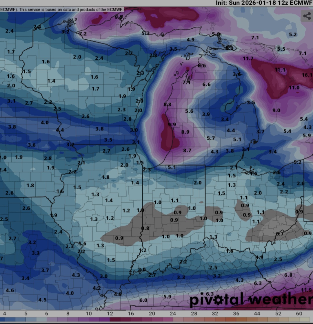
To your point, below are the GFS, Euro, Canadian Ensemble snowfall through the period, and the AI Euro Ensemble snow and the total QPF for the AI GEFS (no snowmap available for this product). All very much in line for much below normal temp and plenty of QPF/snow . -
...to this. Let's see if it continues to expand to our area.
-

Storm potential January 17th-18th
allgame830 replied to WeatherGeek2025's topic in New York City Metro
Not sure what I’m looking at lol… is that a good thing? -
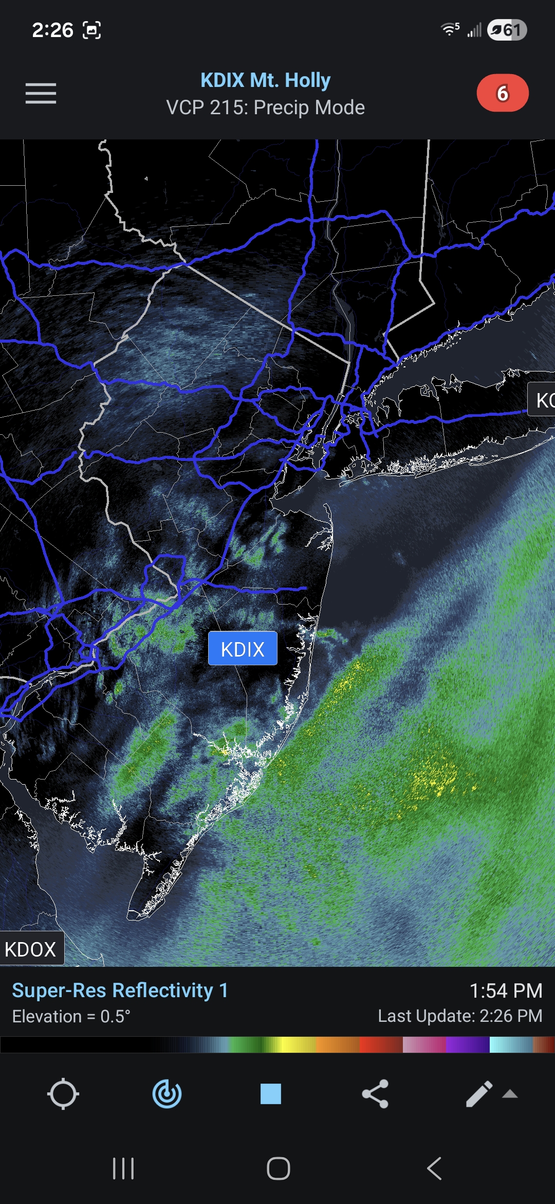
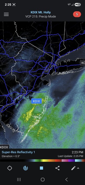
In about 30 minutes, radar went from this...

-
Rise of the Machines: January 18-19 Winter Storm Obs Thread
CoastalWx replied to WxWatcher007's topic in New England
Seems like wind has shifted to ever so might NE. -
 New box map as of 10 mins ago shaved a couple inches off for most.
 -

January 2026 regional war/obs/disco thread
SnoSki14 replied to Baroclinic Zone's topic in New England
Huge if the AI models are anywhere close to being right next weekend -

January 2026 Medium/Long Range Discussion
SomeguyfromTakomaPark replied to snowfan's topic in Mid Atlantic
That was the one that trended north in the last few days. Perfect 6 inches for dc if I remember correctly. -
Definitely don't want to lose power with a potential Arctic front barreling down the Plains a few days later. I am sure the NWS will give this about 48 hours for modeling to get this into focus...and then put out the word. Still a lot of uncertainty right now.
-
The Euro is essentially Feb 2nd 1996.
-
Rise of the Machines: January 18-19 Winter Storm Obs Thread
CoastalWx replied to WxWatcher007's topic in New England
34.5. Slowly falling. Need some more meat. -

January 2026 regional war/obs/disco thread
WinterWolf replied to Baroclinic Zone's topic in New England
Tip beat you to it. 330 hours/14 days out….lol. Gone next run. And that looks like it is well inside the benchmark. -
18z HRRR is still snowing in eastern areas at like 8-9 tomorrrow morning. Advertising a solid 5-6” in snow starved places in SE Mass. I do agree the whole evolution has kind of shunted east, but I’m not sure that matters a ton in this area
-

Rise of the Machines: January 18-19 Winter Storm Obs Thread
moneypitmike replied to WxWatcher007's topic in New England
Fantastic. BOX has lowered my forecast a little from 3-5 to 2-4. GYX has cut my 4-6" down to 1-3. -
Nearly identical to GFS AI
-

Winter 2025-26 Medium/Long Range Discussion
A-L-E-K replied to michsnowfreak's topic in Lakes/Ohio Valley
Cad classic
-

Rise of the Machines: January 18-19 Winter Storm Obs Thread
SouthCoastMA replied to WxWatcher007's topic in New England
You're in a good spot. slightly colder so you'll lose less at the start -
You have a snow map for that? What was the northern cutoff
-
I think initially, we want it suppressed at this range. The cold which pushes after this could be strong. I want to get this within about four days. I could still see this really surging warmth into the TN Valley if something cuts. I can definitely see a scenario where something cuts, draws cold down, and the second wave is snow/ice. But the slider scenario is plausible. For whatever reason, modeling this winter has found a way to be universally wrong from suite to suite. So, I expect a jog north...well north of the GFS as nearly all of the GEFS members are north of the deterministic. But the 12z GFS deterministic is almost to a range it can be trusted, but not quite yet. Fun discussion, but those tracks are gonna move some at this range for sure. I don't want ice either. Ensemble packages look good though at 12z.
-
Pouring Snow here
-
Rise of the Machines: January 18-19 Winter Storm Obs Thread
CarverWX replied to WxWatcher007's topic in New England
Yes It's starting to again. Temp down to 33 -
Agreed. This is probably our best shot for a widespread, warning level snowfall this season. My go/no go would be the 12z runs on Thursday, 1/22. My goal for this window is at least one, widespread warning level snowfall of 6"+. Bonus would be two, warning level snowfalls of 6"+. That would cement the region with it's first above normal snowfall in a decade.
-
big solar flare
-
Rise of the Machines: January 18-19 Winter Storm Obs Thread
CoastalWx replied to WxWatcher007's topic in New England
Not sure I am a fan of that WCB stuff south of LI not really bulging north. Almost wants to slide east. Hope that stuff in NJ blossoms.