All Activity
- Past hour
-

2026-2027 Record-breaking El Nino
40/70 Benchmark replied to Stormchaserchuck1's topic in Weather Forecasting and Discussion
My crude theory is that the planet ultimately finds a way to achieve some semblance of an equilibrium....and this unprecedented El Nino is a testament to that. -
2026-2027 Record-breaking El Nino
40/70 Benchmark replied to Stormchaserchuck1's topic in Weather Forecasting and Discussion
No one is disputing above normal temps...at least in the NE. -

2026 Atlantic Hurricane Season
Windspeed replied to Stormchaserchuck1's topic in Tropical Headquarters
A long-tracking hurricane? Maybe. Perhaps a few long-tracking TCs regardless. One that remains powerful enough to stack ACE? There in lies the problem, or lack of a problem, depending on perspective. Yes, Joaquin occurred during an El Niño season. But you should read up on that TC's meteorological history. Joaquin did not form in the MDR, nor was it even associated with an AEW. That particular TC formed out of a retrograding mid-to-upper cutoff interacting with a remnant surface trough. Despite its stall and eventual high-end intensity, such a system doesn't happen with frequency even during active seasons. My previous post is merely stating, sure, climatology might get us a hurricane, or even a few of them this season, I just doubt we'll see any CV majors cross the MDR and rack up significant ACE with walls of shear. Something might develop, may even flirt with hurricane status, or become a hurricane, but it will probably struggle to reach or maintain major status very long, if at all, to pump up those numbers. Mind you, these comments should also not be confused with significant landfalls or impacts. That could still occur. Yada, yada, yada, it only takes one. At any rate, we're quickly approaching the heart of the season. We shall see. -

2026-2027 Record-breaking El Nino
csnavywx replied to Stormchaserchuck1's topic in Weather Forecasting and Discussion
Ironically, if the increase in Nino variance extends to CP Ninos (as some CMIP6 models suggest may happen soon), then we may see enhanced CP episodes in addition to EP episodes, which ofc will be far more effective for cold winter patterns here. Add in PV disruption via a shoaling Atlantic water into the Arctic (setting up an increasing amount of ridging) and that may also constructively interfere. -

2026-2027 Record-breaking El Nino
michsnowfreak replied to Stormchaserchuck1's topic in Weather Forecasting and Discussion
Hes talking about winters in general, in typical Tip fashion, not just the coming winter. If he wants "a steady diet of nickle and dime storms that add appeal as an active winter pattern" then he needs to go back to his old stomping grounds in west Michigan. That happens very frequently. And BOTH the Great Lakes and New England had one of their all-time snowiest decades on record in the 2010s, which is not ancient history. I sometimes think people long for courier and ives paintings over reality when remembering winters of yore lol. Remember, slightly warmer winter temps in some places are BETTER for snowfall, not worse. -
Currently 8th lowest on NSIDC area. (GaWx has been posting AMSR2 area which is good too, but for consistency purposes, I track NSIDC area since methodology is unchanged since 1979.) Chances of top 5 now are getting slimmer by the day. Too much extended cold on the ESS/Beaufort side this season. You usually want a strong start there so that you are eating away at the CAB in late July and early August rather than wasting those few precious final weeks of higher insolation trying to melt out remnant ice in the Chukchi/ESS/Beaufort.
-
feels like yesterday when the twin cities was crushing it
-

2026-2027 Record-breaking El Nino
donsutherland1 replied to Stormchaserchuck1's topic in Weather Forecasting and Discussion
I agree. I wouldn't be surprised if there are multiple category 4 or above atmospheric rivers this winter. I think it's just impressive that the guidance is hinting at the development of the subtropical jet for the September-November period. That didn't even show up in the fall forecast during the weaker 2023-2024 El Niño. Details about placement are beyond what the guidance can simulate at such timeframes. -
0.05” overnight which brings my August total up to 0.20”
-

2026-2027 Record-breaking El Nino
Keith Central PA replied to Stormchaserchuck1's topic in Weather Forecasting and Discussion
Problem is he has history (strong Nino's) to support his views. You don't have to go out on a limb to forecast above normal temps this winter. Hopefully we are all wrong. -
Summer 2026 Med/Long Range Discussion
CheeselandSkies replied to Brian D's topic in Lakes/Ohio Valley
If anything from the ATL side can survive the Godzilla Nino... -

Augdewst 2026: Summer's Last Stand
dendrite replied to Prismshine Productions's topic in New England
- Today
-
https://www.facebook.com/story.php?story_fbid=1601209068040844&id=100044552974374
-

Augdewst 2026: Summer's Last Stand
Great Snow 1717 replied to Prismshine Productions's topic in New England
You need your own YouTube or Twitch Channel !!! -
was down there last week on vacation-was very nice but no waves since the Atlantic was quiet
-

Augdewst 2026: Summer's Last Stand
CT Valley Snowman replied to Prismshine Productions's topic in New England
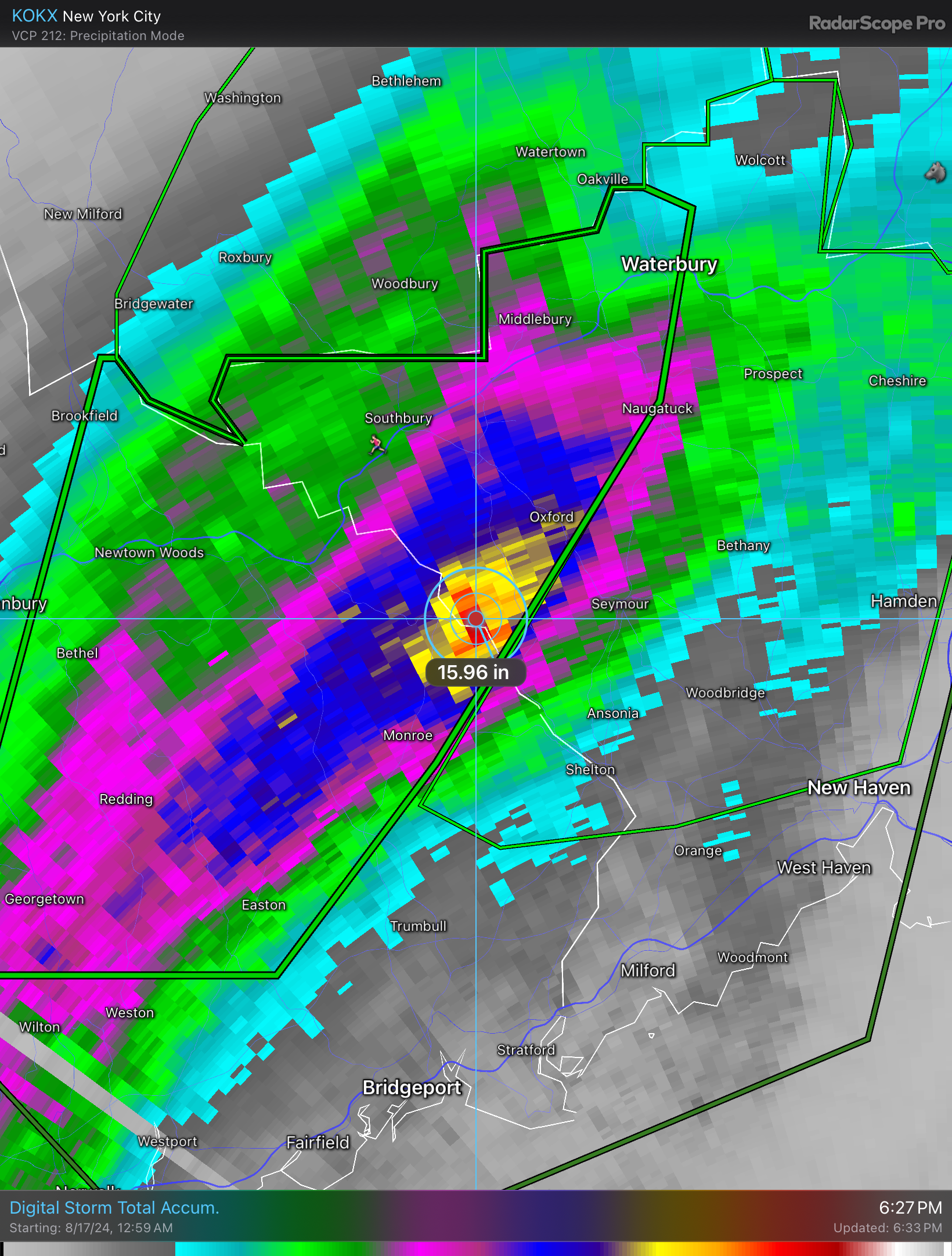
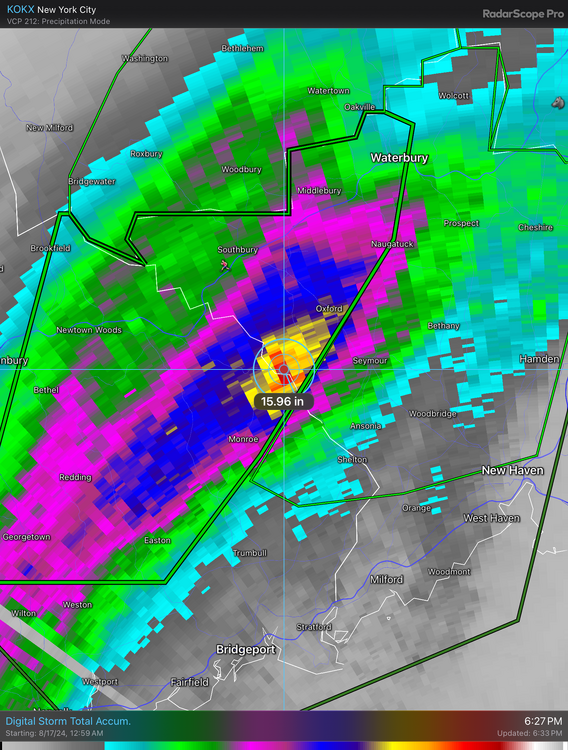
2 years ago today, August 18, 2024, a day Oxford CT and surrounding areas will never forget. I remember looking at the radar in amazement but with the realization that this was going to be a flooding disaster in the hardest hit areas. -
Augdewst 2026: Summer's Last Stand
dendrite replied to Prismshine Productions's topic in New England
Sure. We always laughed at the 3k orographics and knew it was overdoing it in the mtns…it was more of a signal rather than taking the QPF verbatim. The 12k always seemed more zonked in coastals to me even near go-time. The running joke here in the winter is we’re always waiting for that run the day before a SNE biggie that jackpots here to northern VT. But the 3k was really good with CAD and (imo) ptype in those overrunning situations. Convection is hit or miss, but I never saw it as any worse than the other hires models. I just feel like it had its purpose and times where it was useful. We still seem reluctant to dive into full 4dvar like ecmwf. I haven’t talked to Alicia B. in years so I should pick her brain more, but maybe you can explain to me while we’re still messing with 3.5dvar or other hybrids. I remember a study many years ago that showed the gfs error scores were similar to the ec when using their data assimilation. So it seems like there’s value there. -

Augdewst 2026: Summer's Last Stand
vortex95 replied to Prismshine Productions's topic in New England
Ahh, one w/ MPAS! So @CoastalWx need to stop complaining! We have a version of the RRFS to compare and we know it is better. -
Augdewst 2026: Summer's Last Stand
vortex95 replied to Prismshine Productions's topic in New England
WHAN-bulence time! -
Augdewst 2026: Summer's Last Stand
vortex95 replied to Prismshine Productions's topic in New England
The 3km NAM is all over the place for convection, both in areal coverage and location, so I do not use it for that. Also consistent high bias for QPF, esp. orographics, so it goes really nuts w/ snowfall. And any NAM is useless for TC situations, as it never was designed for them. The model initialization is "quick and dirty" for a "first look." That's why it often does odd things beyond about 36 hr. Model initialization is key, and that why the ECMWF is often better and why it is available later b/c they take care for the model initialization. The value goes beyond the weenies that understand the above. For those hype-masters that are always looking for the model that shows "the worst," having something like the NAM just ends up promoting bad/misinformation b/c of it multiple shortcomings. Yes, all models have shortcomings, but let me put it this way, all those memes about the NAM? (the most classic meme attached). They exist for a reason! Yes, we are "used to it" for bias, but we will get used to the RRFS biases as well and its MPAS model core will be implemented in 2028. @CoastalWx needs to move on and realize you can't have it the same forever. By that logic, he would still want the LFM and NGM!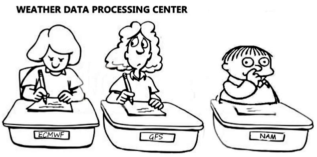
-
Yes, and it's had a negative correlation with winter during the modern era, meaning -AO maybe favored this winter.
-
2026-2027 Record-breaking El Nino
40/70 Benchmark replied to Stormchaserchuck1's topic in Weather Forecasting and Discussion
Tell me why it won't snow ever again in 5,486 words or more- JK -
Water temps 75 - 78 along the NJ beaches / shorte
-

E PA/NJ/DE Summer 2026 Obs/Discussion
Chadzachadam replied to PhiEaglesfan712's topic in Philadelphia Region
DPs are still nasty this morning, hanging in the low-mid 70s. should get some relief this evening and tomorrow -
Issuing a winter outlook, even a preliminary one, in August is dicey.