All Activity
- Past hour
-
I remember the 2024 November elevation dependent storm as another example. I drove up to the Catoctins and the base of the mountain had white rain. After driving up to the trailhead you could see the areas further uphill had accumulations on trees/logs while even 100 ft below there was nothing. Hiking up the critical point was 1200ft where it went from barely anything to sticking to most surfaces coated. I could literally look uphill and see several inches more snow compared to downhill where it was barely a coating. Once past 1500ft it all turned into 5 inches of snow and howling winds. Crazy part is just 50-100 years ago you could move that elevation line down to around 500ft! That would've been a snowstorm for most of MD down to point of rocks! Instead, it was reserved for our few remaining mountaintops that had enough elevation to starve off the warmth.
-
Glad to see the salt washed away for sure.
-
I’m flying over it. Pretty bumpy
-

Early Monday morning 2/16 last minute event OBS/Discussion
Ralph Wiggum replied to The Iceman's topic in Philadelphia Region
Flakes....we have flakes. I counted 4 so far! 36F -
So you think it’s a coincidence that our snowfall has been declining at a proportional rate perfectly correlated to our temperature increase over the last 100 years. We don’t need some long winded anecdotal BS where you cherry pick a low snowfall period (like the 1950s) to THINk you proved something because you project your own stupidity and lack of comprehension of short term variability within long term trends. I realize all of that went over your head bedside you’re a moron. So just answer yes or no.
-
Lol maybe they know your lurking and want to mess with you.
-
Looks like we are getting closer to something next weekend
-

Early Monday morning 2/16 last minute event OBS/Discussion
Birds~69 replied to The Iceman's topic in Philadelphia Region
36f -
Lake Erie is cracking! It's pretty frozen but showing open spots As of recently, Port Clinton and the islands had temps that were in the single digits like everybody else
-
@CAPE I have my own records for 21 years and used a local coop to put together Manchester snow stats going back 70 years. We’ve had more under 20” winters in the last 10 years than we did in the 60 years before! Getting less than 20” used to be unheard of up here, a once every 15 year thing, now it happens every other winter! Similar to how getting less than 10” was once a rare thing in Baltimore and now happens commonly. Looking at my snow data the obvious culprit up here is there used to be a ton of 32-33 degree wet snows from storms that were all rain in DC/Baltimore. Most weren’t huge. A lot of 2-5” type things. I remember some. One was a 3.5” storm in Feb 2013 very similar to this. No cold. Pac puke pattern. Highs near 50 that week. Some weak wave slid by with like .45 qpf and it flipped to 33 degree snow and we got 3.5” of wet slop. Only up on the ridge. Even in town for only 2 and Westminster like 1”. Nothing south of there. Super marginal. This strikes me as the same exact type thing only slightly warmer so…I’m 34.7 right now and raining! Those little 33 degree 3-4” wet snows are missing and there why suddenly my bad winters up here are 17” instead of 27”
-
Early Monday morning 2/16 last minute event OBS/Discussion
Birds~69 replied to The Iceman's topic in Philadelphia Region
Really didn’t expect it till much later 9pm+…some breeze as well. -
I mean in a way you can think of every year as the snow line slowly moving upwards in elevation. You would now need an extra 1000ft or so to get the same snowfall averages of pre climate change.
-

Presidents' day Snow potential
Bxstormwatcher360 replied to WeatherGeek2025's topic in New York City Metro
Its coming bud. Also precip(virga) building east into nnj from pa. -
For those who use Gibson Ridge products, I found a new way to get placefiles. One of them I found is NWS alert areas (all watches/warnings/advisories) shown on the radar screen https://placefilenation.com/#placefiles
-
Early Monday morning 2/16 last minute event OBS/Discussion
Ralph Wiggum replied to The Iceman's topic in Philadelphia Region
He'll probably be asleep. You may as well just invite yourself in -
Sitting at 0.85” with rain still falling
-
Early Monday morning 2/16 last minute event OBS/Discussion
Birds~69 replied to The Iceman's topic in Philadelphia Region
There’s some flakes falling… -
Presidents' day Snow potential
Bxstormwatcher360 replied to WeatherGeek2025's topic in New York City Metro
We gotta see where the northern fronto band sets up. Nyc is looking prime for that band rn,precip expanding east into nyc with heavier bands developing might give us a positive bust later. I expect more then the "inch" that everyone is harping about. 33/26f cloudy. -
Sweden will be tough, assuming they beat Latvia (which they should). But if US plays like they did today, I like our chances to get to the gold medal game.
-
It probably affects us all proportionally. Long term avg here is 18.5. No idea what it is now, but its less than that.
-
Doesn't look like much of anything coming north of 195, or is that because the radar is down?
-

Early Monday morning 2/16 last minute event OBS/Discussion
The Iceman replied to The Iceman's topic in Philadelphia Region
Can I crash at casa de red sky? I think you’re in the best spot for this abomination lol -
This area up here can, or at least used to, snow in some pretty nefarious setups. It’s why I averaged 40 and DC only 15! I don’t think I average 40 anymore. Maybe 35 now. It’s finally affecting up here now too!
-
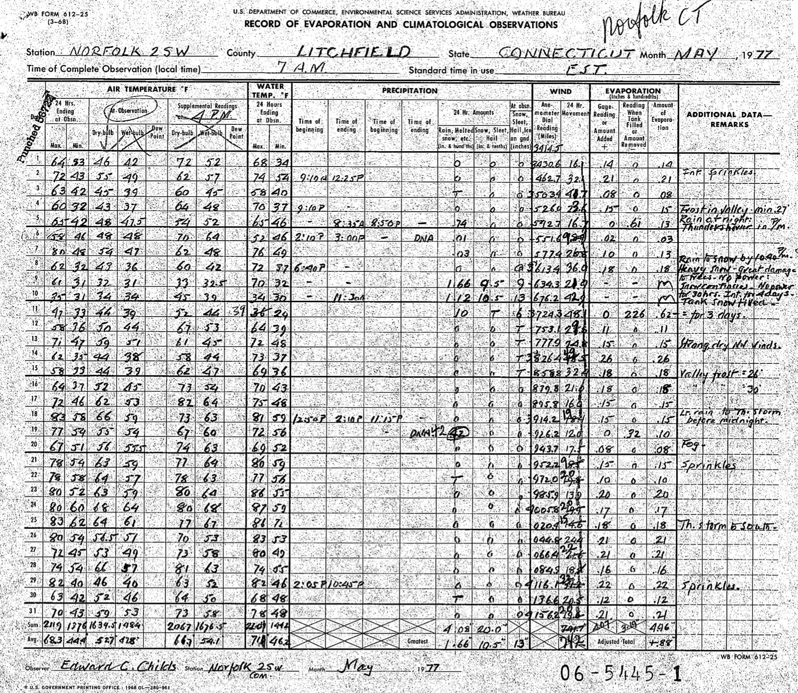
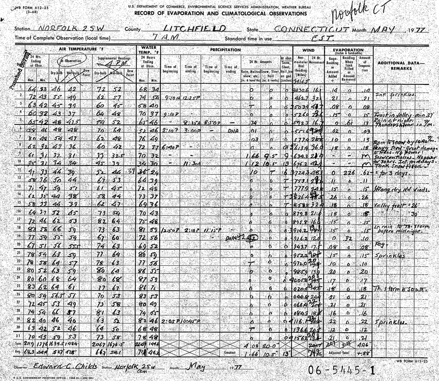
The old form for Norfolk from May 1977. Fun times.
-
38° with rain and a snow-eating fog. Visibility less than 1 mile. 0.25” in the bucket.