All Activity
- Past hour
-
 Haltan0 joined the community
 -
Doesn’t look like anything exciting late night. All the good instability is in NY state. Could be good for nrn NY into VT. Maybe a little better out west by Berks.
-
MEX is starting to pop some 100s up here Tue. Gfs ends the week with 50s and rain Thu/Fri. Currently 54.4°
- Today
-
Models over the last few days have hinted at this for the past few days, although the track of this feature is still a bit uncertain. There is a pretty apparent split in outcomes between the global models and the convective-allowing models; the global models (GFS, ECMWF, NAM- 12) all take this feature across far northern New England or adjacent Quebec late tonight with little to no impact to SNE. On the other hand, the majority of the CAMs have trended further SW, essentially backbuilding the southern end of the MCS into the considerably more unstable air, with a potential MCS moving over parts of or all of SNE during the pre-dawn to early Sunday morning hours (approx 3 to 8 AM). Although surface based instability progs at that time of day are essentially nil, steepening lapse rates aloft support nearly 1500 J/kg of MUCAPE with increasing effective shear to around 40-45 kt, a shear/instability space which could support embedded elevated supercells above more stable sfc layer. There still is quite a bit of uncertainty regarding this feature`s track and how strong it may become, were it to affect our area. The outcomes here range from passing us by to the north, to an overnight to early-day MCS capable of hail, wind damage and torrential rain. I ended up following the trends in the CAMs, which increase PoPs into the 15-25% range for the southern coast, and increasing to around 30- 50% for northern MA. After coordinating with the neighboring WFOs, also included enhanced wording for gusty winds, hail and heavy downpours. While not set in stone, there has been an uptrend in at least some overnight/early-Sunday impact from this convective complex. Stay tuned on this situation.
-
Also missed the point that the warming has become sustained and prolonged even if max temps don't pass previous highs. That's a far bigger CC indicator than how hot it gets. However even with that, we may just challenge that too. Because once we surpass previous baselines, it becomes much easier to hit new all time records.
-
Extreme Heat Warning URGENT - WEATHER MESSAGE National Weather Service State College PA 302 AM EDT Sat Jun 21 2025 PAZ036-056-057-059-063>066-220800- /O.UPG.KCTP.XH.A.0001.250622T1500Z-250626T0000Z/ /O.NEW.KCTP.XH.W.0001.250622T1500Z-250626T0000Z/ Franklin-Perry-Dauphin-Lebanon-Cumberland-Adams-York-Lancaster- Including the cities of Chambersburg, Lebanon, Newport, Gettysburg, Lancaster, Harrisburg, Hershey, York, and Carlisle 302 AM EDT Sat Jun 21 2025 ...EXTREME HEAT WARNING IN EFFECT FROM 11 AM SUNDAY TO 8 PM EDT WEDNESDAY FOR THE LOWER SUSQUEHANNA VALLEY... * WHAT...Dangerously hot conditions with heat index values over 105 expected for the Lower Susquehanna Valley. * WHERE...Adams, Cumberland, Dauphin, Franklin, Lancaster, Lebanon, Perry, and York Counties. * WHEN...From 11 AM Sunday to 8 PM EDT Wednesday. * IMPACTS...Heat related illnesses increase significantly during extreme heat and high humidity events. * ADDITIONAL DETAILS...Heat index values and the associated risk of heat-related impacts will be highest on Monday and Tuesday. PRECAUTIONARY/PREPAREDNESS ACTIONS... Drink plenty of fluids, stay out of the sun, and stay in an air-conditioned room. Check up on relatives and neighbors, and provide pets with adequate water and shelter from the sun. Extreme Heat can be life-threatening among at-risk populations, such as children, the elderly, and those with pre-existing health conditions. In addition to the daytime heat, overnight low temperatures will also be very warm and oppressively muggy. && $$
-
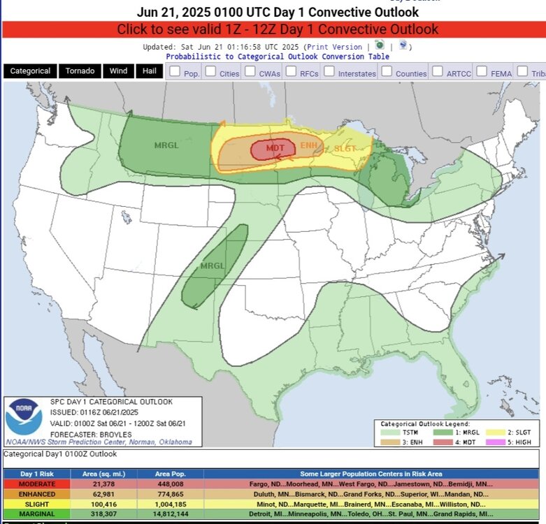
https://www.spc.noaa.gov/products/outlook/day1otlk_0100.html
-
I changed my original reply because after I thought about it I realized that It came off as being very belittling to Mount Joy Snowman . I truly didn't intend it to be . He's seems like a stand up guy. I'm an idiot what can I say.
-

June 2025 discussion-obs: Summerlike
LongBeachSurfFreak replied to wdrag's topic in New York City Metro
Where climate change is a factor is in the strength and staying power of the ridge. If we hit 600dm that likely is directly attributable to CC. We can break that record and still not break temp records. JFK needs a wind vector of WNW to NW, for a daily record. The Park needs surrounding stations to be 105 to hit 100. So lots of little intricacies on a local level. -
I know I’m a little late with this but wtf was up with that wind yesterday? It was gorgeous but man that breeze was whipping, like some kind of tropical system was racing by. Couldn’t believe it at times. I guess now we wait with baited breath for the wall of heat to make its presence felt! Many shirtless (perhaps shortless?) days lie ahead..
-
 Extreme Heat Warnings issued for just about everyone minus the city/island
 -
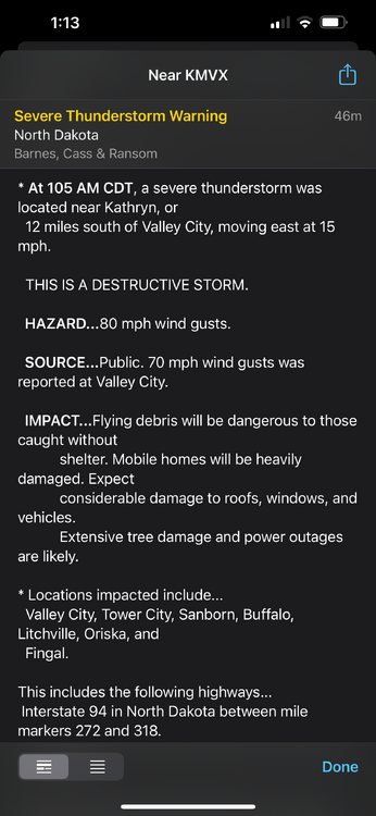
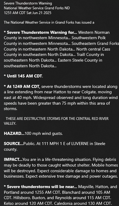
Even this gust front got a severe thunderstorm warning with a “destructive” tag. It’s incredible how much wind energy there is.
-
Iowa Derecho 2.0
-
99 percent of Liberty’s posts are insane and ridiculous
-
Liberty gonna Liberty
-

E PA/NJ/DE Summer 2025 Obs/Discussion
PhiEaglesfan712 replied to Hurricane Agnes's topic in Philadelphia Region
It's officially Go Birds season when we see this in the forecast. -
As a strong believer in climate change and global warming I think this is ridiculous and outrageous. There have been heatwaves going way back. By allowing yourself to rate climate change according to the weather on a day or two you are promoting the ability of deniers to come back when it snows or is cold for a day or two and say, "see there's no climate change". It's absurd and it is NOT what climate change is. It is far bigger and based on statistics globally over 100s of years. It is not a hot day or a snowstorm. WX/PT
-

2025-2026 ENSO
40/70 Benchmark replied to 40/70 Benchmark's topic in Weather Forecasting and Discussion
Agree. I don't necessarily mean a frigid December...just active and not prohibitively warm. -

2025-2026 ENSO
Stormchaserchuck1 replied to 40/70 Benchmark's topic in Weather Forecasting and Discussion
I agree, I also think there is an above average tendency for -EPO periods to happen with +NAO.. that is an above average precip pattern in the eastern 1/2. Clippers have become less common though, so the low pressure will likely need to tap into the Gulf. I'm getting a few warm things for Dec, although I know the small sample of -Neutral ENSO and -QBO favors a cold December. -
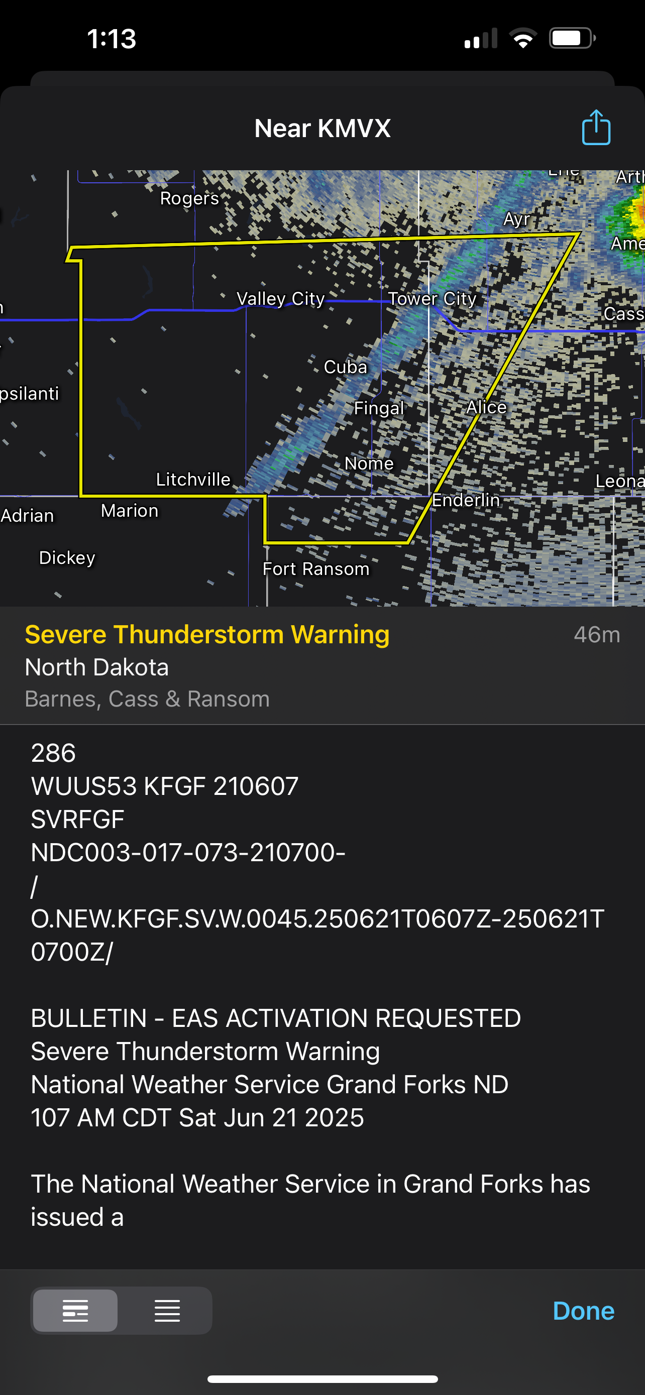
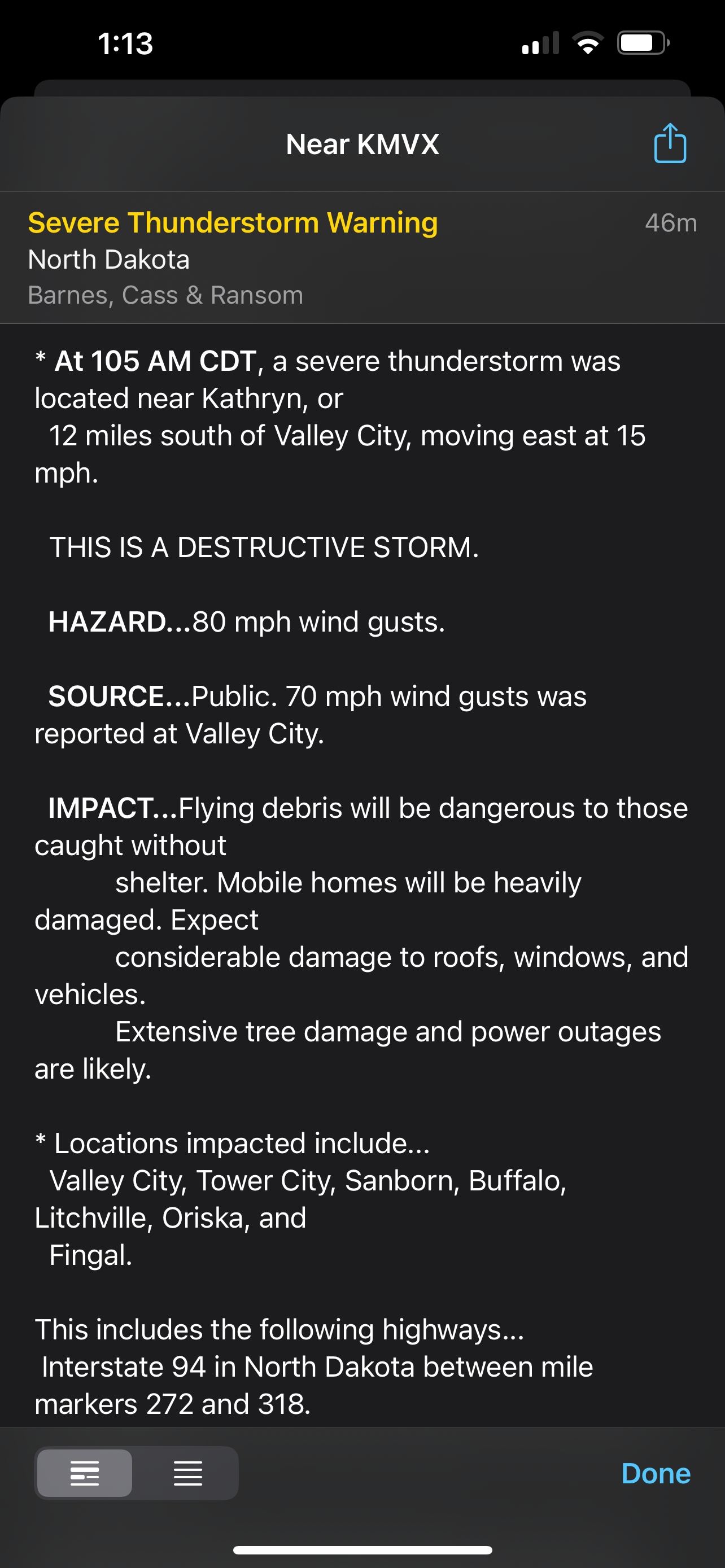
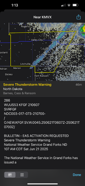
Warnings for 90 mph winds in North Dakota currently
-
2025-2026 ENSO
40/70 Benchmark replied to 40/70 Benchmark's topic in Weather Forecasting and Discussion
I also think we may see a pretty fast start this December...will get into why later in the season, but it originates from the QBO/solar stuff. -
2025-2026 ENSO
40/70 Benchmark replied to 40/70 Benchmark's topic in Weather Forecasting and Discussion
I think the common denominators will be poleward ridging in the Pacific and pronounced period(s) of negative NAO in the midst of a decidedly +NAO season....-PNA likely hits hardest when the -NAO shows up, which should allow for a much more active storm track in the NE. -
This is not correct. No other stations were 82. Sacrus posted the numbers.
-
Is there wildfire smoke out there? Super smoky smell but I guess it could be a neighbor’s fire pit.
-
already feeling super gross outside with PTK reporting 71/66 as of 11PM. the brief rain showers this morning (0.11" imby) and stagnant overcast has led to a yuckening of the night that I can only describe as "wearing soup" or "sweaty underpants" my dehumidifier is going full BTO, takin' care of business (and working overtime, wooo)
-

E PA/NJ/DE Summer 2025 Obs/Discussion
Kevin Reilly replied to Hurricane Agnes's topic in Philadelphia Region
No power still 35 hours and counting no restoration time estimated.


.thumb.jpg.6a4895b2a43f87359e4e7d04a6fa0d14.jpg)