All Activity
- Past hour
-

“Cory’s in LA! Let’s MECS!” Jan. 24-26 Disco
Prismshine Productions replied to TheSnowman's topic in New England
Imagine taking the Pope over 30 seconds over actually looking at the model... Sent from my SM-S166V using Tapatalk -

Pittsburgh/Western PA WINTER ‘25/‘26
MikeB_01 replied to Burghblizz's topic in Upstate New York/Pennsylvania
Good morning, all. NAM is running. Lets keep track on this 12z suite. -

January 25/26 Jimbo Back Surgery Storm
NorthHillsWx replied to Jimbo!'s topic in Southeastern States
I’m ready to get hurt again -

Southern MD / Lower Eastern Shore weather discussion
AlexD1990 replied to PrinceFrederickWx's topic in Mid Atlantic
Beyond disappointed with the trends on this one, given what was being shown 2 days ago. will still enjoy what falls, hope for less freezing rain, and the upside is it does stick around for a while. Will continue to hope that the afternoon models trend colder. -
As the LWX AFD mentioned, I'd use the 10:1 instead of the Kuchera for now. Even though most of the initial thump will have good ratios, towards the end, it'll get closer to the gray area, probably leading to somewhat wetter snow and smaller ratios.
-

January 25/26 Jimbo Back Surgery Storm
Brick Tamland replied to Jimbo!'s topic in Southeastern States
It'll probably show that up until 4 days out and then go -
 eps 0z run shows snow changing to sleet around Mahopac, NY and south!
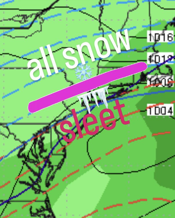
-
It’s at the end and the damage was already done.
-
FWIW can extrapolate to CT
-
I’ll start the thread.
-

January 24-26: Miracle or Mirage JV/Banter Thread!
nw baltimore wx replied to SnowenOutThere's topic in Mid Atlantic
I keep looking at the NWS US map and shaking my head. Once NE gets winter storm watches, nearly two-thirds of the country will have watches or warnings because of this storm. And it goes on for at least several days. I haven't been this excited for winter weather in a long, long time. -

Possible Record Breaking Cold + Snow Sunday 1/25 - Tuesday 1/27
NEG NAO replied to TriPol's topic in New York City Metro
why and where ? and what evidence do you have to back up that statement other than warm model runs 3 days in advance of the storm ? -
“Cory’s in LA! Let’s MECS!” Jan. 24-26 Disco
Prismshine Productions replied to TheSnowman's topic in New England
Rule of thumb: not in the bullseye, cry foul. I have a chance to see the most single-storm snowfall in my life so I am just sitting back and waiting Sent from my SM-S166V using Tapatalk -

January 24-26: Miracle or Mirage JV/Banter Thread!
wxdude64 replied to SnowenOutThere's topic in Mid Atlantic
If you pound it into the ground to the 6" mark you'll enjoy watching a lot more! -
And when I mention warmer it’s at the end but as I said earlier, It was the 06z euro and it only got as far as LI.
-

“Cory’s in LA! Let’s MECS!” Jan. 24-26 Disco
SouthCoastMA replied to TheSnowman's topic in New England
Kind of a mixed bag. Seemed colder with the initial thump, and a bit warmer along coast when the secondary got cranking. ^regarding 6z Euro AI. -
Thanks was going off the MA forum analysis.
-

Pittsburgh/Western PA WINTER ‘25/‘26
southpark replied to Burghblizz's topic in Upstate New York/Pennsylvania
I'll reserve judgement until they put out the next one since that should cover the scope of the storm. -
.thumb.png.4150b06c63a21f61052e47a612bf1818.png)
“Cory’s in LA! Let’s MECS!” Jan. 24-26 Disco
HIPPYVALLEY replied to TheSnowman's topic in New England
It’s unfounded panic because Pope has scared some people into thinking the primary low is eventually tracking over Albany. -
Sunsets after 5:00 for the first time since Nov 1st today. We;ve gained 32 mins of total daylight from the solstice Sunrise slowly earlier at 7:14AM / Sunset : 5:02 PM
-
(002).thumb.png.6e3d9d46bca5fe41aab7a74871dd8af8.png)
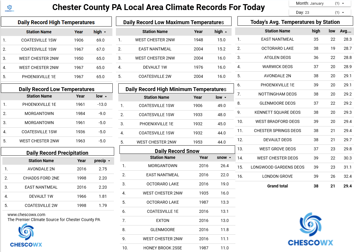
Central PA Winter 25/26 Discussion and Obs
ChescoWx replied to MAG5035's topic in Upstate New York/Pennsylvania
A significant winter storm begins toward midnight on Saturday night. Today should be our last relatively mild day for the rest of the month of January and into the start of February. Tomorrow we return to near normal temperatures with highs in the middle 30’s. An arctic cold front will cross the area later tomorrow afternoon temperatures will fall quickly to single digits above zero by midnight. Saturday will be very cold and breezy with highs only in the mid-teens. The snow arrives overnight and continues through at least 1pm on Sunday. By that point, most areas of Chester County could see between 6” to 8” of snow. At some point after that we should begin to see the snow mix with and change to sleet and freezing rain from SE to NW across the area This will cut into any additional potential snow accumulations. The final snow/sleet accumulation totals will depend on how fast this changeover occurs. Either way there will be plenty of snow and sleet accumulation. Unseasonably cold weather follows the storm with temperatures likely not rising above freezing for possibly at least the next 10 days.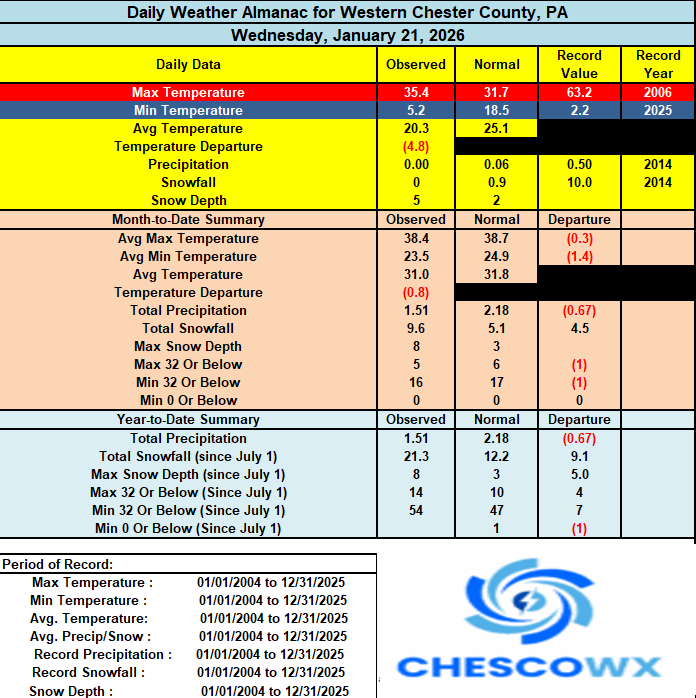

-

January 24-26: Miracle or Mirage JV/Banter Thread!
RickinBaltimore replied to SnowenOutThere's topic in Mid Atlantic
Damnit, I needed G-47! -

Pittsburgh/Western PA WINTER ‘25/‘26
Burghblizz replied to Burghblizz's topic in Upstate New York/Pennsylvania
Good info and good balanced take. I’ll still look at the clown maps and dream, but great info for what is more likely (which isn’t bad at all) -
NAMped?
-
06z was a bit warmer.