All Activity
- Past hour
-
 Still more rainfall after this across NC
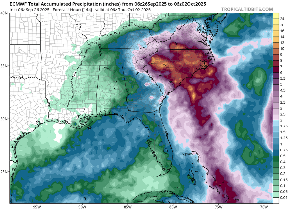
-

2025-2026 ENSO
40/70 Benchmark replied to 40/70 Benchmark's topic in Weather Forecasting and Discussion
This data set illustrates my point about how crucial the WPO will be. All of these seasons except for 1998, which sucked, had a -WPO. Having a favorable WPO leaves much more margin for error, so hopefully the western warm pool is offset enough by the NE PAC warming so that it isn't so extreme this season. A strongly positive WPO leaves virtually no margin for error around the rest of the hemisphere, so if anything else is significantly unfavorable, then most of us are cooked and upside is near normal. -
We’ll be lucky if we get half an inch and even that is starting to look overly optimistic. Walk backs beget further walk backs.
-

Occasional Thoughts on Climate Change
donsutherland1 replied to donsutherland1's topic in Climate Change
And the fact check on the political report aimed at reversing the EPA's endangerment finding. https://interactive.carbonbrief.org/doe-factcheck/images/Carbonbrief-DOE-factcheck.pdf -

September 2025 OBS-Discussion centered NYC subforum
SACRUS replied to wdrag's topic in New York City Metro
Records: Highs: EWR: 90 (2007) NYC: 91 (1970) LGA: 90 (2007) JFK: 87 (1970) Lows: EWR: 40 (1940) NYC: 42 (1940) LGA: 44 (1947) JFK: 47 (1949) Historical: 1936 - Denver, CO, was buried under 21.3 inches of snow, 19.4 inches of which fell in 24 hours. The heavy wet snow snapped trees and wires causing seven million dollars damage. (26th-27th) (David Ludlum) (The Weather Channel) 1936: The heaviest snowfall ever recorded in September and the heaviest snowfall ever recorded so early in the season dumped a total of 16.5 inches of snow on downtown Denver and 21.3 inches at Denver Municipal Airport. The 15.0 inches of snow measured from 6:00 PM on the 27th to 6:00 PM on the 28th is the greatest 24-hour snowfall ever recorded in September. This was the first snow of the season. The snow was intermittent on the 26th, but continuous from early afternoon on the 27th to around midnight on the 28th, except for a period of rain during the afternoon of the 28th. 1936: A forest fire burned several miles east of the town of Brandon, Oregon. The fire was far enough away that residents were not particularly worried. A sudden shift in the winds drove the flames westward and through town. The fire, caused by summer drought and fueled by the abundant Gorse Weed found in many of the empty spaces between buildings in Bandon, caused so much destruction that only a handful of structures were left standing when the fire finally died down. 1936 - A forest fire burned several miles east of the town of Bandon, Oregon. The fire was far enough away that residents were not particularly worried. A sudden shift in the winds drove the flames westward and through town. The fire, caused by summer drought and fueled by the abundant Gorse Weed found in many of the empty spaces between buildings in Bandon, caused so much destruction that only a handful of structures were left standing when the fire finally died down. 1942: A severe freeze was experienced across the upper Plains and Midwest from the 26th to the 28th. The temperature at Parshall, ND dropped to a record low of 4° on this date. Winona, MN dropped to 25°, their coldest September temperature. Also on this date, snow fell across parts of Minnesota, Iowa and Wisconsin. Locations recording their earliest measurable snowfall included: Caledonia, MN: 5 inches, Fayette, IA: 1 inch and La Crosse, WI: 0.2 of an inch. Snow fell in early morning, mostly melting as it fell. (Ref. AccWeather Weather History) 1950 - Residents of the northeastern U.S. observed a blue sun and a blue moon, caused by forest fires in British Columbia. (David Ludlum) 1953: The center of Hurricane Florence hit the northwest Florida coast between Valparaiso and Panama City near midday with wind maximum sustained winds near 80 mph with gusts to 90 mph and heavy rainfall. The Pensacola Weather Bureau Office reported winds of up to 75 mph early the next morning. The storm passed inland over a sparsely settled area of Florida and this probably accounts for the rather small amount of damage. In Franklin and Okaloosa Counties the Red Cross estimated that 273 homes were destroyed, 145 other buildings damaged, and three destroyed. A fishing trawler, the "Miss Tampa" was reported missing in the storm's wake. (Ref. Wilson Wx. History) 1955: On this date, the Atlantic reconnaissance aircraft, ”Snowcloud Five” went down while investigating Hurricane Janet and was never heard from again. Lt. Comdr. Windham with a crew of 8 and two newspapermen reported that they were about to begin penetrating the central core of the hurricane. The hurricane made landfall at peak intensity near Chetumal, Mexico on September 29th. Janet's landfall as a Category 5 hurricane on the Yucatán Peninsula was the first recorded instance that a storm of such intensity in the Atlantic made landfall on a continental mainland; prior to Janet, landfalls of Category 5 intensity were only known to have taken place on islands. 1963 - San Diego, CA, reached an all-time record high of 111 degrees. Los Angeles hit 1S09 degrees. (David Ludlum) 1970 - Santa Ana winds brought fires to Los Angeles County, and to points south and east. Half a million acres were consumed by the fires, as were 1000 structures. Twenty firemen were injured. (25th-29th) (The Weather Channel) 1971: Project Stormfury was an attempt to weaken tropical cyclones by flying aircraft into them and seeding with silver iodide. The project was run by the United States Government from 1962 to 1983. Hurricane Ginger in 1971 was the last hurricane Project Stormfury seeded. 1979 - In the midst of a hot September for Death Valley, California, the afternoon high was 104 degrees for the second of three days, the coolest afternoon highs for the month. (The Weather Channel) 1985: Hurricane Gloria weakened briefly while moving from northeast of the Bahamas to just off the southern North Carolina coast by days end. Gloria peaked the previous day with maximum sustained winds of 145 mph and a minimum central pressure of 920 millibars or 27.17 inches of mercury. Gloria weakened during this date to 90 mph at 06z and 12z before regaining strength intensifying to 100 mph by days end. Washington, DC area was lucky as hurricane Gloria stays well east of Washington, DC. (Ref. Wilson Wx. History) 1987 - Freezing temperatures were reported in the Northern and Central Appalachians, and the Upper Ohio Valley. The morning low of 27 degrees at Concord NH tied their record for the date. Temperatures soared into the 90s in South Dakota. Pierre SD reported an afternoon high of 98 degrees. (The National Weather Summary) 1988 - Unseasonably warm weather prevailed across Florida. Afternoon highs of 92 degrees at Apalachicola and 95 degrees at Fort Myers were records for the date. (The National Weather Summary) 1989 - Rain spread from the southeastern states across New England overnight. Cape Hatteras NC reported measurable rainfall for the fourteenth straight day, with 15.51 inches of rain recorded during that two week period. Phoenix AZ reported a record high of 108 degrees, and a record 134 days of 100 degree weather for the year. Afternoon temperatures were only in the 40s over parts of northwest Wisconsin and Upper Michigan. (The National Weather Summary) 1998: Record warm weather across the Great Lakes and Ohio Valley fueled a severe weather outbreak as a cold front arrived during the late afternoon. A severe thunderstorm produced softball-sized hail in Clare County which smashed skylights, dented automobiles, and damaged roofs and antennas. Damage was estimated at up to half a million dollars. Record highs for the date included: Toledo, OH: 92°, Columbus, OH: 92°, Detroit, MI: 91°, Cleveland, OH: 91°, South Bend, IN: 91°-Tied, Flint, MI: 90°, Chicago, IL: 90°, Grand Rapids, MI: 89°, Lansing, MI: 89°, Jackson, KY: 87° and Mansfield, OH: 87°-Tied. (Ref. Wilson Wx. History) 1998: There were four hurricanes were spinning simultaneously in the Atlantic basin: Georges, Ivan, Jeanne, and Karl. That was the first time this had happened since 1893. 2004 - After making its infamous loop east of the Bahamas, Hurricane Jeanne made landfall the night of September 26th, 2004. Jeanne came ashore as a major category 3 hurricane just a few miles away from where Hurricane Frances made landfall a few weeks before. Jeanne produced extensive damage along the east central Florida coast from Volusia County south to Martin County. The highest wind gusts occurred over extreme Southern Brevard County as well as Indian River County with 110 - 120 mph estimates at the peak of the storm. (NWS, Melbourne, FL) -
Sounds like orb weavers. They’re great at killing other bugs. Non venomous to humans
-
Yeah I won't bother them if they're outside, but inside that is a different problem . But yeah the number I've seen outside, especially larger spiders is very noticeable. Actually, I've grown to not care as much if they are inside anymore but its the crawling that creeps me out. I probably should have gotten this addressed when I was a kid...no clue where it started or what sparked it but this fear of spiders is an awful thing...if I see one near me it elicits this intense response in my body. I hate it.
-
Penn State!
-

September 2025 OBS-Discussion centered NYC subforum
Stormlover74 replied to wdrag's topic in New York City Metro
Especially when its the nam showing the rain coming furthest north -
September 2025 OBS-Discussion centered NYC subforum
SACRUS replied to wdrag's topic in New York City Metro
72 / 67 clear. Low / mid 80s and a chance to get to 80 the next 4, including today which would make it 7 straight for the warmest areas. Clouds the factor Sat-Sun. Showers / storms possible overnight Sat into Sun but drying/clearing by the sunday day break. Humberto / Imelda next week with what should be Imelda going into the S/C Carolina borders and we'll see if anything comes up this way eventually in the 105-10/7 period.. Overall warm here through he 10th, could see some brief cool down between the 1-3 with E/NE/ENE flow for 2 days. By the 10th trough into the northeast looks shortlived - overall warmer beyond there. -
2025-2026 ENSO
40/70 Benchmark replied to 40/70 Benchmark's topic in Weather Forecasting and Discussion
This data set actually has some nice winters for my area...2004, 1993, 1992 and 1960 were great, very good, great and very good. 1974 and 2016 were respectable. 1979-1980 was my lowest snowfall season ever and 1998 sucked. I think I would take this data set over the other one TBH.
-

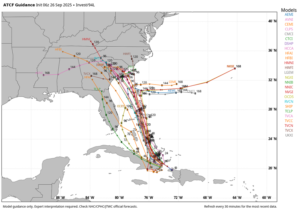
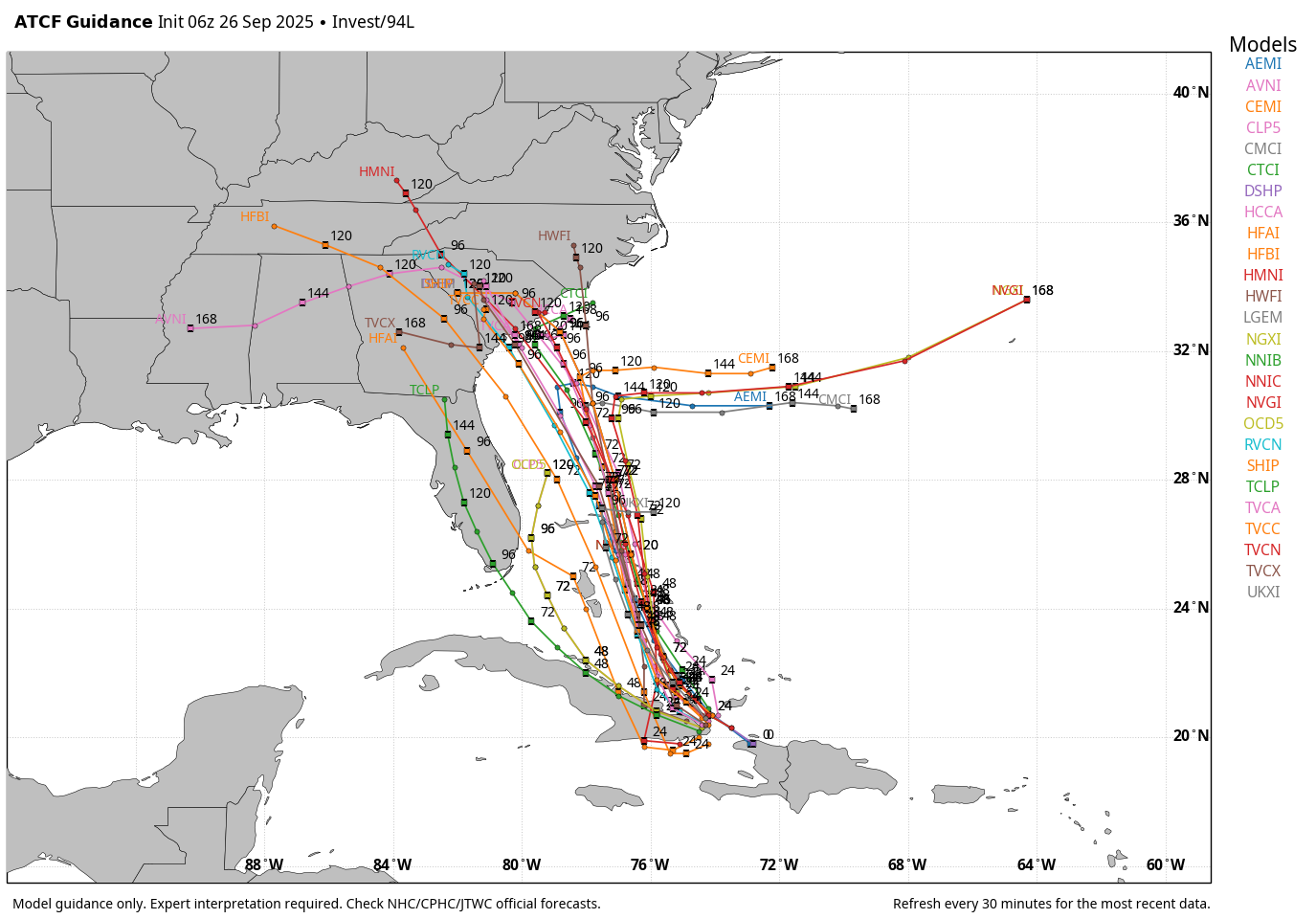
Invest 94L—80% 2 day and 90% seven day odds of development
GaWx replied to WxWatcher007's topic in Tropical Headquarters
Hopefully Humberto overachieving increases the chance that 94L will be more influenced by it in a way that helps the SE US. -

September 2025 OBS-Discussion centered NYC subforum
jm1220 replied to wdrag's topic in New York City Metro
Greater than 50-50 chance IMO the Sat overnight into Sun rain just gets confluenced/crushed south. We recently had a situation where the north end of one of these just dried up and models were too aggressive. Happens all the time in these confluence situations-dry air just eats up any precip and models are over-aggressive bringing it north. -
I’m seeing a bunch outside. Found a large one hanging out in the wheel well of my car in the driveway. I moved him to a place in the garden. I love spiders as long as they’re outside. They keep all the flying pest populations in check. To me, the signs outside are that our ++AN temp fall persistence is just now kicking off.
-

September 2025 OBS-Discussion centered NYC subforum
Dark Star replied to wdrag's topic in New York City Metro
An old saying, "Live by the LFM, die by the LFM". Now we have multiple models, but it comes down to the forecaster to judge what will actually occur based on experience. Easier said than done. -
WB 6Z tracks
-

September 2025 OBS-Discussion centered NYC subforum
psv88 replied to wdrag's topic in New York City Metro
Nice weekend on tap. Talk about a bust -
Yes, I had a dog and 3 cats, that's why I bought it. The WP stands for wet powder. Once it dried it left a small amount of powder that killed all insects.
-

September 2025 OBS-Discussion centered NYC subforum
steve392 replied to wdrag's topic in New York City Metro
That 1.07" is right near me. Seems like an outlier compared to everyone else. Either way it was a good rain to feed the plants and grasses. -
So all this rain really did is wet the surface. Plants that are still in a growth phase, like my raspberries, are happy but the soil is dry an inch down.
-
2025-2026 ENSO
40/70 Benchmark replied to 40/70 Benchmark's topic in Weather Forecasting and Discussion
Agreed RE him, but I can't every recall you being on the decent winter train, either...and notice I say "decent winter" as opposed to "cold". It's never cold anymore, but there have been decent winters. -
Just to illustrate the difficulty of this forecast, here are the 500mb height anomalies from the 0z Euro, Euro AI, and GFS. They clearly show that 94L's eventual track is hugely dependent on the speed and placement of both 94L and Humberto when they have their Fujiwhara interaction. Three scenarios are showing up. In the GFS solution, Humberto throws 94L into the South Carolina coast, and it quickly moves inland. Scenario 2, shown by the Euro, has Humberto partially capturing 94L, causing it to stall right on the S.C. coast but eventually releasing it. Again, 94L strikes the S.C. coast, but a bit further south and weaker. The Euro AI has a weaker and faster Humberto, which interacts earlier with 94L and causes that same stalling further out to sea. When 94L eventually gets free, it heads out to sea instead of west.
.thumb.png.26f6716d7fd11b22a141f970a35cbb3b.png)
.thumb.png.5d46deccf01139e8cda6ff44e390a2e0.png)
.thumb.png.7a8af89f9bdc1c412d6cd65b135f6525.png)
-
Have fun!!!! The last white out I was at was our victory over Ohio State that changed the trajectory of the program. Sent from my SM-G970U1 using Tapatalk
-
Is that stuff safe for dogs/cats?
-
I used to get them in my other house, they would crawl across my desk now and then. I bought some Demon WP and sprayed inside and out and didn't see any after that.


.png.0c19218a50e4def1337f5c0db7e86e32.png)
.png.a65ac6935f8c7e5c09206d12331581f7.png)
.png.a21307c57a9661862a22fa45df0f253e.png)
