All Activity
- Past hour
-

Extreme Cold, Snow & Sleet: SECS 1/25 - 1/26
TriPol replied to TriPol's topic in New York City Metro
I wouldn't pay attention to the GFS inside of 24 hours. HRRR is my go to at this point, although I'm pretty giddy about the RRFS coming soon. -

Extreme Cold, Snow & Sleet: SECS 1/25 - 1/26
weatherpruf replied to TriPol's topic in New York City Metro
I’m actually glad to see it. What’s the famous scene in Citizen Kane… his old sled, Rosebud… a child’s memory of playing in the snow….saw a 78 year old retired superintendent recently, I asked him how they made school decisions. He said when it comes to snow he is like a kid again. He’d go out at 4 am with grounds supervisor to see three schools; if the grounds guy said close the schools he did. -

Extreme Cold, Snow & Sleet: SECS 1/25 - 1/26
Snowlover11 replied to TriPol's topic in New York City Metro
GFS definitely warmer, that mix line literally cuts the city. -

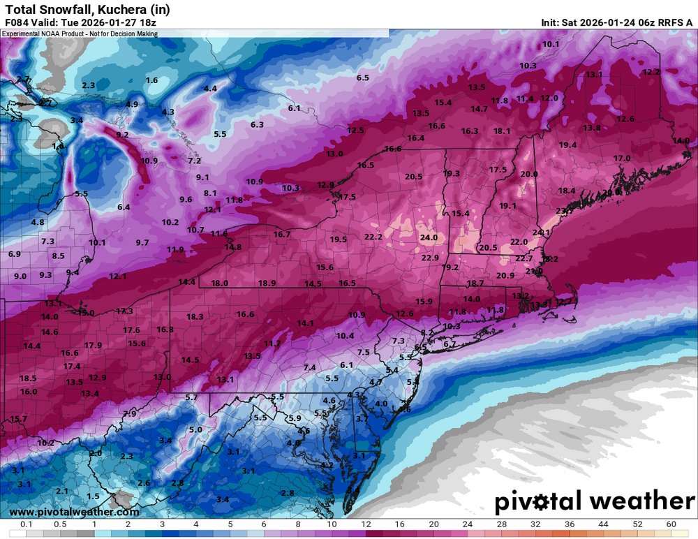
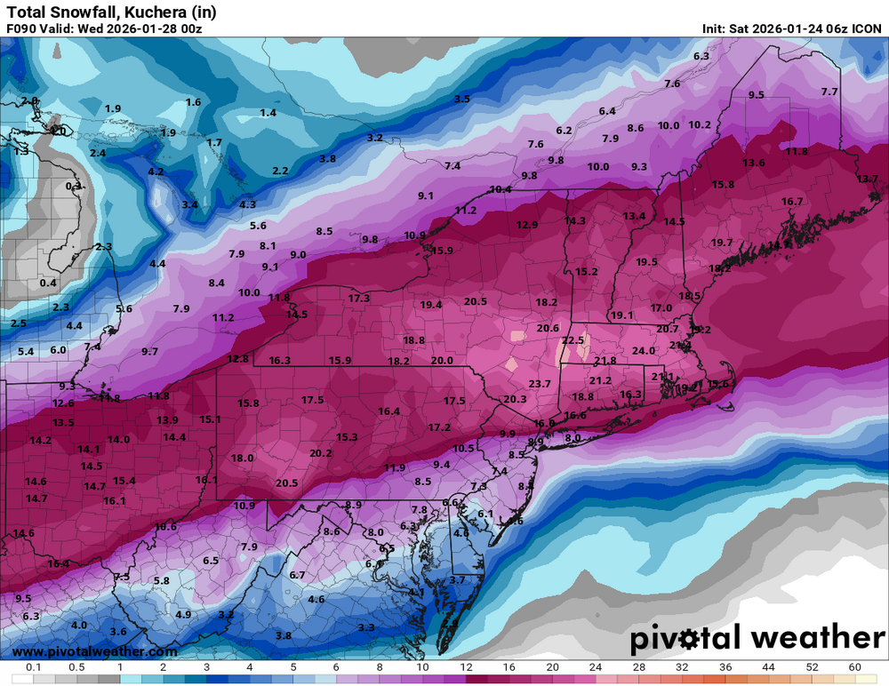
Jan 24-26 Weekend Snow and Sleetfest Model Thread Part Tres
DDweatherman replied to H2O's topic in Mid Atlantic
The 6z RRFS and ICON were not very good runs for the region. -

Southern Crippler - Get well soon Jimbo Storm Obs
BornAgain13 replied to BooneWX's topic in Southeastern States
29.6/8.8 -

Extreme Cold, Snow & Sleet: SECS 1/25 - 1/26
MJO812 replied to TriPol's topic in New York City Metro
Gfs is warmer and sleet gets into the NYC area faster. Cut down totals to single digits -
4 degrees. If the over under line for Orange County was 15 inches, using Goshen which is close to the middle of the county do you take the over or under? I would take the over but I think it's close.
-
It's not unheard of to get severe storm warnings for cells in winter storms. I recall it during the crazy Texas storms before.
-
Ya we take!!
-
ICON KOOCHIE!!!
-

Extreme Cold, Snow & Sleet: SECS 1/25 - 1/26
dmillz25 replied to TriPol's topic in New York City Metro
Down to 8 here -

Extreme Cold, Snow & Sleet: SECS 1/25 - 1/26
Volcanic Winter replied to TriPol's topic in New York City Metro
CNJ / middle third is a tough forecast I’m thinking, anywhere in the battleground / changeover stripe is gonna be a tough call. Depends further if we’re talking accumulating sleet or white rain, or even ice - not so sure that’s well resolved. Hoping the city gets blasted, but for here I’m really not sure. Mt Holly is still fairly aggressive even with their now reduced totals (7-13). Accuweather has near even odds between 8-12, 4-8, and even 2-4 which underscores what I’m talking about. Could bust high or bust low, tough one. Down to 10 with a -6 DP! I’d say the arctic air has arrived . Still falling. -

Central PA Winter 25/26 Discussion and Obs
pasnownut replied to MAG5035's topic in Upstate New York/Pennsylvania
well that's a good f'in way to start the day!! -
Extreme Cold, Snow & Sleet: SECS 1/25 - 1/26
TriPol replied to TriPol's topic in New York City Metro
I missed the 2016 blizzard and the 2021 snowstorm. It's been a long time since I've seen this. Yeah, I'm excited about it. So what? Do you have to be rude about it? -
I see the same uncertainty the normal liminal spaces, the floor is just higher. The thing is there's a massive sensible and aesthetic differences between having a snowstorm then rain then some more on top, than having a nice pack. That's how you get that horrible false last stair feeling as a kid as you fall through that layer of hardened ice. Beggars can't be choosers and all that, but I'm sadly sitting this one out, so it's not even that. Oh, and many millions of people live in one of the liminal spaces. More than the entire "we know what we are getting" area combined.
-

Southern Crippler - Get well soon Jimbo Storm Obs
Coach McGuirk replied to BooneWX's topic in Southeastern States
We are all probably going to get a good ZR event. -

January 2026 regional war/obs/disco thread
dendrite replied to Baroclinic Zone's topic in New England
-3° roaring -

Extreme Cold, Snow & Sleet: SECS 1/25 - 1/26
CPcantmeasuresnow replied to TriPol's topic in New York City Metro
You're getting a little hyperbolic. Unless you're under age ten I believe we've all seen 2-3 inch rates per hour many times. It's great but not a once in a lifetime. Get a grip man you're becoming a NY post headline. -
So, do you think the precipitation will be mostly sleet in the CAD regions, like upstate SC?
-

Southern Crippler - Get well soon Jimbo Storm Obs
lilj4425 replied to BooneWX's topic in Southeastern States
I feel like I am gonna be sick. -
Extreme Cold, Snow & Sleet: SECS 1/25 - 1/26
CPcantmeasuresnow replied to TriPol's topic in New York City Metro
That's half an inch of sleet on LI which is nothing. -
Southern Crippler - Get well soon Jimbo Storm Obs
Coach McGuirk replied to BooneWX's topic in Southeastern States
sick -
NWS already started scaling back the warnings. Down to 11-15in in Allentown from the initial 12-18in.
-
FWIW NAM kind of stopped its own bleeding. Still many areas don’t hit the low end of their projected NWS snows, but it as *slightly* better than 0z
-

Southern Crippler - Get well soon Jimbo Storm Obs
CentralNC replied to BooneWX's topic in Southeastern States
Looks at these 4am obs though. Cold air is screaming down the lee side. And those DPs! CITY SKY/WX TMP DP RH WIND PRES REMARKS WASHINGTON NAT PTCLDY 14 -9 35 N24G30 30.60R WCI -5 DULLES PTCLDY 11 -10 38 N15G23 30.60R WCI -5 ANDREWS AFB PTCLDY 14 -13 30 N17 30.55R WCI -3 QUANTICO CLEAR 16 -10 31 N20G33 30.59R WCI -1 COLLEGE PARK* PTCLDY 13 -12 32 N16 30.61R WCI -3 LEESBURG* PTCLDY 10 -6 48 MISG 30.61R MANASSAS* CLEAR 13 -8 39 N17 30.61R WCI -4 GAITHERSBURG* PTCLDY 9 -10 42 VRB6 30.57R WCI -1