All Activity
- Past hour
-
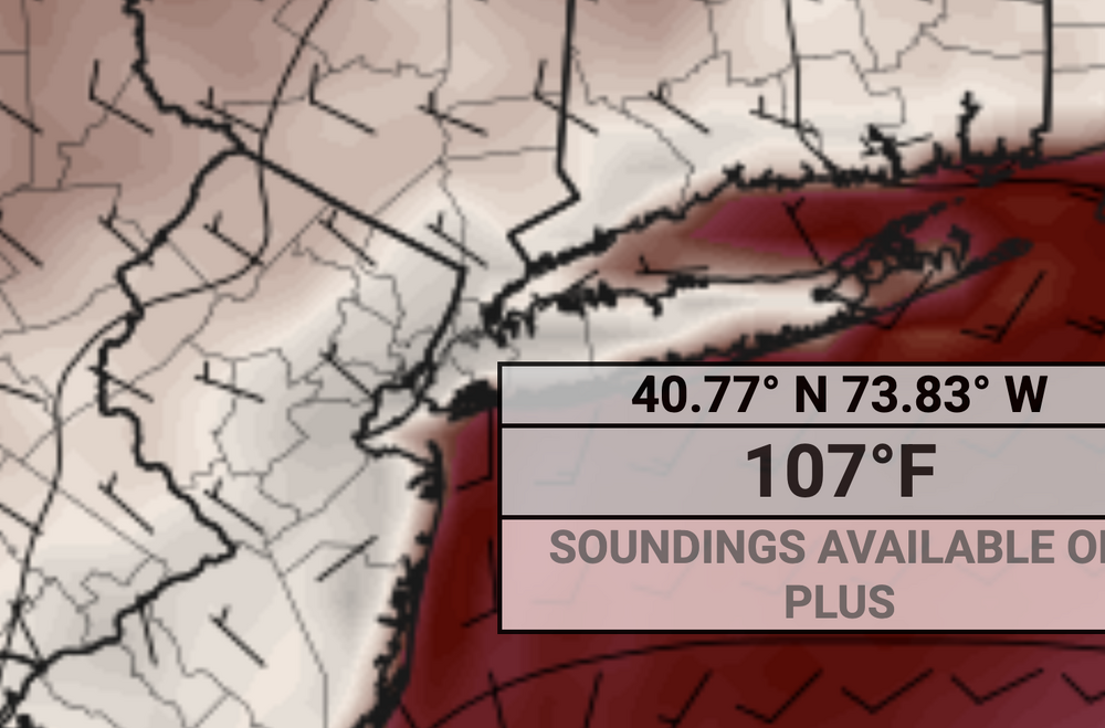
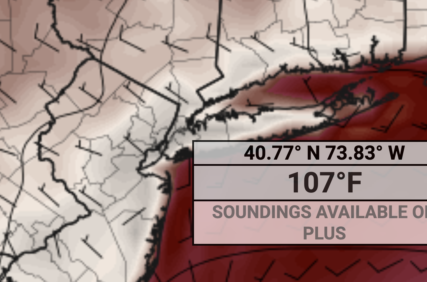
MAX temps are rprobably arouynd 110F because that map is the temperature at 2PM, I have no doubt with that type of flow we would get daytime highs a couple hours later.
-
I have zero confidence the ripoff artists known as CONED can keep the power on with those types of temps
-
These WNW flow heat events are where we really roast and heights are absurdly high. We’ll see if that verifies (107 is likely too high but could definitely be 100+ if we get the downslope WNW flow) or it becomes our more typical southerly flow FL type heat.
-
It's actually a HAIR cooler for next Monday because the wind is more off the water by a tad compared to 0z. But 12z keeps heating up more and more for next Tuesday.
-
Sounds like a real treat with all the excess water evaporation around it will feel like Calcutta
-

2025 Short Range Severe Weather Discussion
A-L-E-K replied to Chicago Storm's topic in Lakes/Ohio Valley
would take the 12z euro -
Euro now has 107 degrees next Tuesday in NYC.
-

E PA/NJ/DE Summer 2025 Obs/Discussion
RedSky replied to Hurricane Agnes's topic in Philadelphia Region
A balmy 62F with dark November like sky and light rain -
Up to about 0.5” of much needed soaking rain.
-
I’d hedge that it’s all overdone a bit…mixing and 850s. Knock a couple C off and expect the dews to overperform as usual. 96-99/70 type stuff.
-

2025 Short Range Severe Weather Discussion
Stebo replied to Chicago Storm's topic in Lakes/Ohio Valley
Saturday has my interest. -
That direction is what makes records in Aroostook.
-
Seek help and stop posting asap
-
Could very well be.
-
Really might want to be check for diabetes and get a relative humidity sensor. Warm air holds more moisture so heating this time of year will allow indoor air to become more moist. Mold is not killed by 85 degree heat. It is killed by sunlight and lack of moisture. So unless you are UVing the room, that heat won’t be killing it. You also should not have mold in a properly build house, so that should be remediated. Diabetes also makes the body feel cooler than it is. Sleep experts all recommend sleeping below 68 degrees.
-
Omg

-
I think most of the region is about to get very Steiny
-
GFS Steins your area pretty good.
-
TWN forecasting Tues the most humid day of 2025 yet, 30C humidex of 36C/97F. Similar to last Monday WUN has just a 25% of any precip while TWN is 40% for most of mid-day including strong storms. Will TWN catch another storm WUN misses? Today way over-performed I'm at 28C not 25, a relief from the clouds too.
-
We kinda needed it up that way after missing all weekend. Glad to get some decent rain in the ground ahead of upper 90s next week...
-
101/62 would work
-

2025 Short Range Severe Weather Discussion
roardog replied to Chicago Storm's topic in Lakes/Ohio Valley
Next weekend looks like it could be interesting as the heat starts to move northeast. It could be one of those situations where most of the sub is hot and capped but our area could be far enough northeast for something. -
But the wait time to be in need of the facilities post consumption, is about 30 seconds.
-
Just speaking to the gfs but yep that’s how it’s done. If the flow is more deep layer W-NW then you aren’t getting oppressive dews in the afternoon. I do think it’s still going to be muggy overall.
-
This year looks different though in the sense that the western US is going to be very cool with maybe some significant snow in the mountains.


.thumb.png.4150b06c63a21f61052e47a612bf1818.png)


