All Activity
- Past hour
-
Sure looking more likely someone in that Area you noted is good to get Hammered with Snow and Ice. Heavy Snow on Northern Boundary but Sleet and freezing Rain a pretty wide swath likely in the middle probably.
-

Rise of the Machines: January 18-19 Winter Storm Obs Thread
moneypitmike replied to WxWatcher007's topic in New England
I didn't see this posted......here's the 17z HRRR total qpf. Big bust at Pit2. -

Storm potential January 17th-18th
BxEngine replied to WeatherGeek2025's topic in New York City Metro
Latest forecast map. Go take a jebwalk or something.
-
Light intermittent snow starting at lake Anna. Thought it would mix initially so that’s a nice surprise. Might get a coating if lucky.
-

January 2026 regional war/obs/disco thread
ORH_wxman replied to Baroclinic Zone's topic in New England
AIs are liking the overrunning system while OPs suppressing it. Let’s see how consistent AI is in the coming few days vs the OPs. Wonder if we see another bias-correction win for the AIs….I had mentioned just a couple posts up how you often see those types of systems come north. I wonder if the AI models already know that from past data and are correcting for it. It will be interesting to track either way. -
EPS 4-5", favors south central VA
-

January 2026 Medium/Long Range Discussion
BTRWx's Thanks Giving replied to snowfan's topic in Mid Atlantic
Not a peep about the massive moisture plume coming out of the Gulf next week on the euro?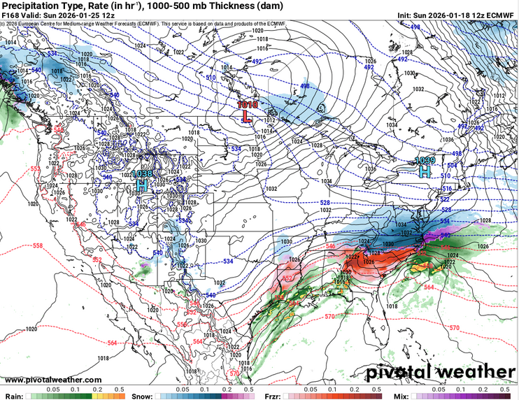
-
Agreed temps are slowly dropping
-

Rise of the Machines: January 18-19 Winter Storm Obs Thread
CoastalWx replied to WxWatcher007's topic in New England
-RASN. 35. -
Yeah, man. We want none of that. The cold air looks vey likely. The wild card is whether the STJ gets its act together. We have seen "false positives" this winter with it. Like I said above though, this event is within five days for folks in Arkansas...and almost four.
-
This will be the one time Goofus is correct
-

January 2026 Medium/Long Range Discussion
SomeguyfromTakomaPark replied to snowfan's topic in Mid Atlantic
And that’s still damn good! I like we where we stand. -

Rise of the Machines: January 18-19 Winter Storm Obs Thread
tomcatct replied to WxWatcher007's topic in New England
Snow pickimg up nicely down here in Trumbull..( sw ct)..got about 2 inches this morning -

Rise of the Machines: January 18-19 Winter Storm Obs Thread
WxWatcher007 replied to WxWatcher007's topic in New England
.5" here with the first round. -

Rise of the Machines: January 18-19 Winter Storm Obs Thread
Damage In Tolland replied to WxWatcher007's topic in New England
There was a pretty tight gradient yesterday from N and W of 84 to S And E. Though UConn campus today had 3-4”. They must be in South Willington? https://www.weather.gov/source/crh/snowmap.html?zoom=8&lat=41.64&lon=-71.61&hr=24 -
The concern, and we have talked about this for at least a week...is that this potential cold air mass will form a gradient boundary which presses west to east. The cold air will submarine under warm air, and that creates the conditions needed for ice. We dodged one window this past week as the STJ didn't attack the base of the trough. The STJ looks to show some life right now at the worst possible time - and you all know I like winter, but not ice. Again, a lot will change and that should be noted in all caps. But it sure looks increasingly likely that somewhere between Birmingham and Lexington is gonna see a winter storm and maybe a bad one.
-

Rise of the Machines: January 18-19 Winter Storm Obs Thread
weatherwiz replied to WxWatcher007's topic in New England
Yeah any warning amounts would probably be too isolated or localized to really justify a warning. -

Storm potential January 17th-18th
NorthShoreWx replied to WeatherGeek2025's topic in New York City Metro
You are overestimating the warm. -
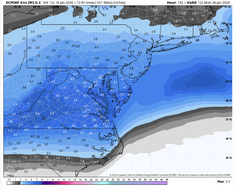
GEFS's snow signal for Jan 25-27 is actually the weakest signal out of the ensembles. GEFS: ~4" EPS: ~5" EPS-AI: ~7"
-
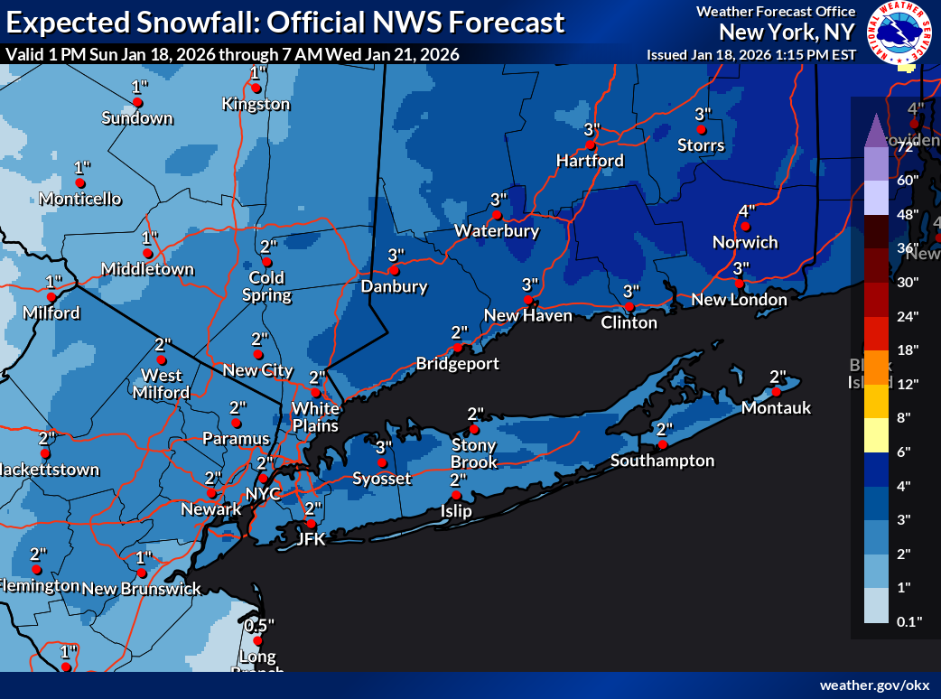
Their latest forecast map has central Park at 4.4 when all is said and done
-

Storm potential January 17th-18th
sussexcountyobs replied to WeatherGeek2025's topic in New York City Metro
Not true. NWS forecast for CP is 2-6". The park needs only 1.6" for forecast range to verify. -
 I feel like box has outlined this well. Someone could sneak in a 7-8” amount, probably somewhere in Bobs hood would be my guess. And they’ve shown this on their map
 -

January 2026 regional war/obs/disco thread
Sey-Mour Snow replied to Baroclinic Zone's topic in New England
Both AI models are a carbon copy for next weekend PD3 type of setup -
Depends on the timing of the cold push. In place cold vs cold with front .
-

Rise of the Machines: January 18-19 Winter Storm Obs Thread
Sled replied to WxWatcher007's topic in New England
Wow. I just plowed my inlaws in Willington and they had maybe 2".