All Activity
- Past hour
-

2026-2027 Record-breaking El Nino
MJO812 replied to Stormchaserchuck1's topic in Weather Forecasting and Discussion
I haven't even seen one post on twitter about 2009-2010. No one is claiming that -

2026-2027 Record-breaking El Nino
mitchnick replied to Stormchaserchuck1's topic in Weather Forecasting and Discussion
You're comparing October to December. Don't you think that's probably not a fair comparison to draw any conclusions for this year since we're 5 weeks from the start of December and 9.5 from the end? -
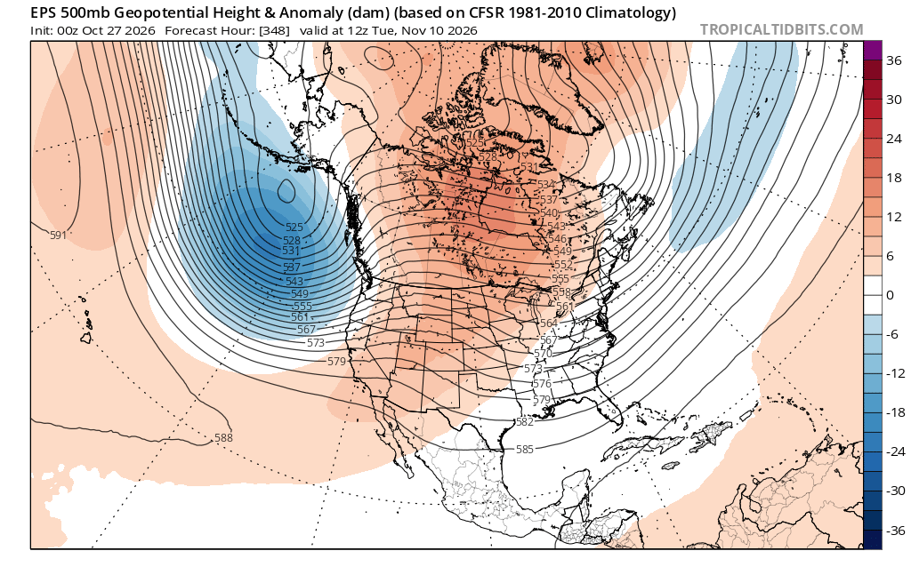
BTW, here's the GOAT early season polar disruption. No way am I calling for another 2009-10, just posting for comparison. The Japanese marine heatwave is killing us of late.
-
If this is true, then you know which direction I hope they're coming from...
-
2026-2027 Record-breaking El Nino
mitchnick replied to Stormchaserchuck1's topic in Weather Forecasting and Discussion
Great news. Warmer temps, less energy consumption, and less pollutants. Aren't you celebrating? -
Best part of this timing is we won’t have to listen to sun angle comments for any potential snowfall opportunities
-
Not sure about record warmth yet but does look solidly above average. Which by next week is 65 to 70
-
Could have our first fall winter severe storm system of the year with this upcoming second season .
-
There are always questions about whether any SSW or wind reversal will couple appropriately with the polar vortex. This 3D modeling suggests that it will successfully disrupt things all the way to the surface, which is hopeful to at least mute a torch December. I'm not expecting a miracle in the snowfall department this winter, just climo snowfall.
-
I don't even bother looking at anything until post-Thanksgiving. Some can't help but torture themselves with 10 day OP model runs in October, which boggles the mind.
-
2026-2027 Record-breaking El Nino
LakePaste25 replied to Stormchaserchuck1's topic in Weather Forecasting and Discussion
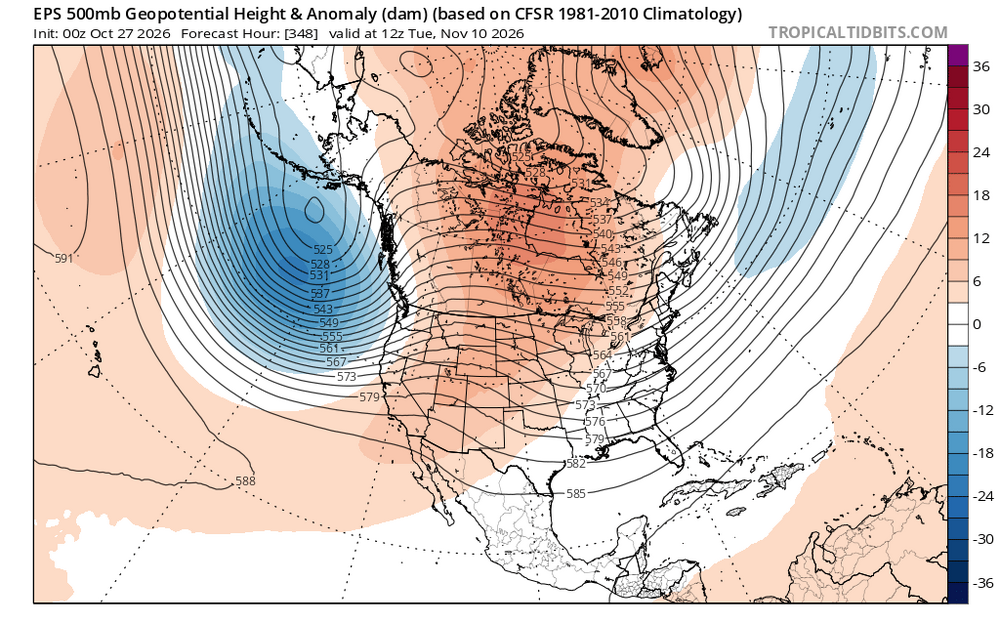
Yeah, the pacific vortex being much further west in December 2009 allowed the blocking pattern to pin TPVs under the block. The vortex is much closer to the west coast with these E based events, so even with a good blocking pattern the cold would be very fleeting as the vortex pushing warm air into canada will try to scour it out. 2009: Now: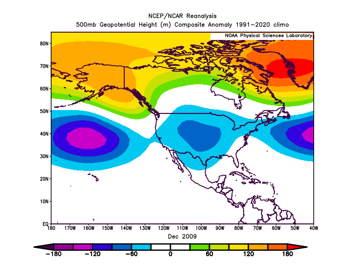
-

2026-2027 Record-breaking El Nino
bluewave replied to Stormchaserchuck1's topic in Weather Forecasting and Discussion
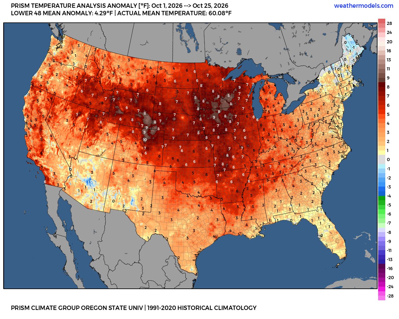
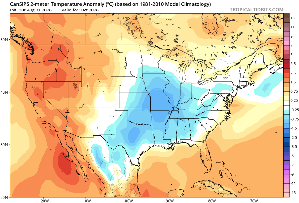
Overall much too cool a forecast for the CONUS in October since we are in top 5 warmth territory. Climatologist49 @climatologist49.bsky.social Follow After finishing with the record warmest July, the record warmest August, and the record warmest September, the Contiguous U.S. is on pace to have the 4th warmest October on record. The warmest, 1963, was 4.8F above normal. It's still possible that this October could move higher up the list. 11:30 AM · Oct 23, 2026 -

2026-2027 Record-breaking El Nino
snowman19 replied to Stormchaserchuck1's topic in Weather Forecasting and Discussion
One thing is for sure. These ridiculous, bombastic claims on twitter today that 2009-10 is the best “analog” for this winter are going to go down in flames. That is quite possibly the worst analog in the entire history of mankind. It’s actually laughable and embarrassing that anyone would think that’s a perfect match for this year. Fantasy, cope, deep denial, fake news, delusion and wishcasting at its finest -
October 27 1943: Residents would describe this event as 'one of the worst fogs in the Twin Cities in memory'. A very dense area of fog blanketed the area. In the thickest fog, street lights could not be seen 25 yards away. Drivers refused to cross unmarked railroad crossings and traffic was brought to a standstill. 1931: An intense area of low pressure moves into the Duluth area. The barometer falls to 29.02 inches. For Tuesday, October 27, 2026 1764 - A "very remarkable storm of snow with high winds" produced 22 inches at Rutland in central Massachusetts. (David Ludlum) 1929 - A snowstorm dumped 27 inches upon Ishpeming, MI, in 24 hours to establish a state record. (David Ludlum) 1962 - An early season winter storm over New England blanketed northern Maine with 7 to 16 inches of snow, and southeastern New England with up to 3 inches of snow. Worcester MA received a record 4.7 inches of snow. (The Weather Channel) 1987 - Showers and thunderstorms produced locally heavy rain from Virginia to New York State. Fallen leaves made roads and sidewalks slick, and also clogged sewers. Rainfall totals of 1.55 inches at Newark NJ, 1.54 inches at Harrisburg PA, 1.27 inches at Scranton PA, and 1.22 inches at Atlantic City NJ, were records for the date. (The National Weather Summary) 1988 - Low pressure brought snow and gale force winds to the Great Lakes Region, and snow and high winds to the north central U.S. Winds gusted to 47 mph at Lansing MI, and reached 55 mph at Pierre SD. (The National Weather Summary) (Storm Data) 1989 - Wintry weather invaded the northwestern U.S. A storm crossing the Central Rockies produced up to 23 inches of snow in the mountains east of Salt Lake City UT. "Indian Summer" continued in the Lower Ohio Valley and the Upper Great Lakes Region. Afternoon highs of 71 degrees at Marquette MI and 72 degrees at Sault Ste Marie MI were records for the date. (The National Weather Summary) (Storm Data) Observances: 27 Tue National Black Cat Day 27 Tue World Occupational Therapy Day 27 Tue National American Beer Day 27 Tue World Day for Audiovisual Heritage 27 Tue National Mentoring Day 27 Tue Cranky Co-Workers Day 27 Tue National Henry C. Ramos Day 27 Tue Navy Day
-

2026-2027 Record-breaking El Nino
GaWx replied to Stormchaserchuck1's topic in Weather Forecasting and Discussion
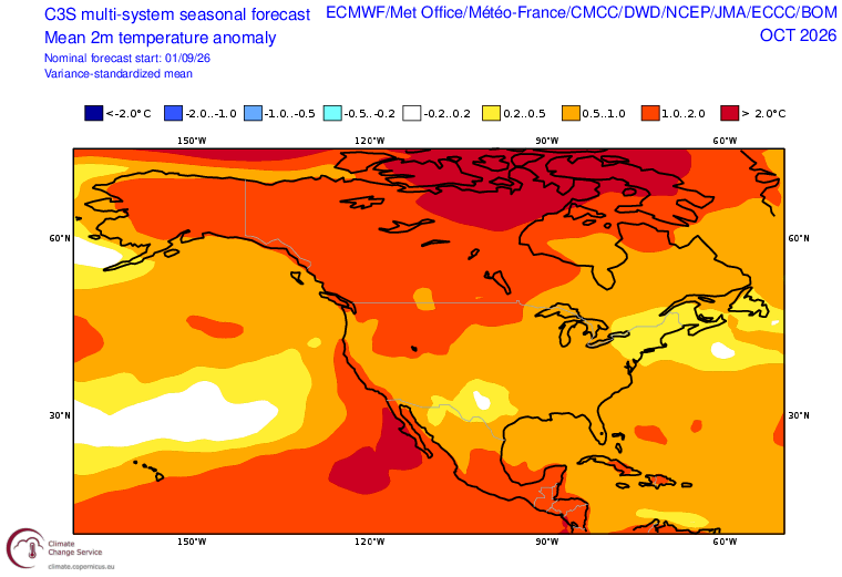
But note that the CS3 Oct ‘26 mean for the E coast states has verified quite well based on Oct 1-25. -
These last few pages are gold. Tweets, obscure models, it has everything. The reality is, it’s 70+ this week and it doesn’t look like we’re cooling down anytime soon. You know the winter looks bleak when you have to dig really deep to find something positive
-
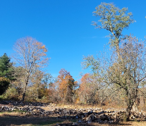
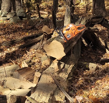
Stunner. Perfect day to collect some firewood. Big old black locust. Throw it right in the stove.
-
2026-2027 Record-breaking El Nino
bluewave replied to Stormchaserchuck1's topic in Weather Forecasting and Discussion
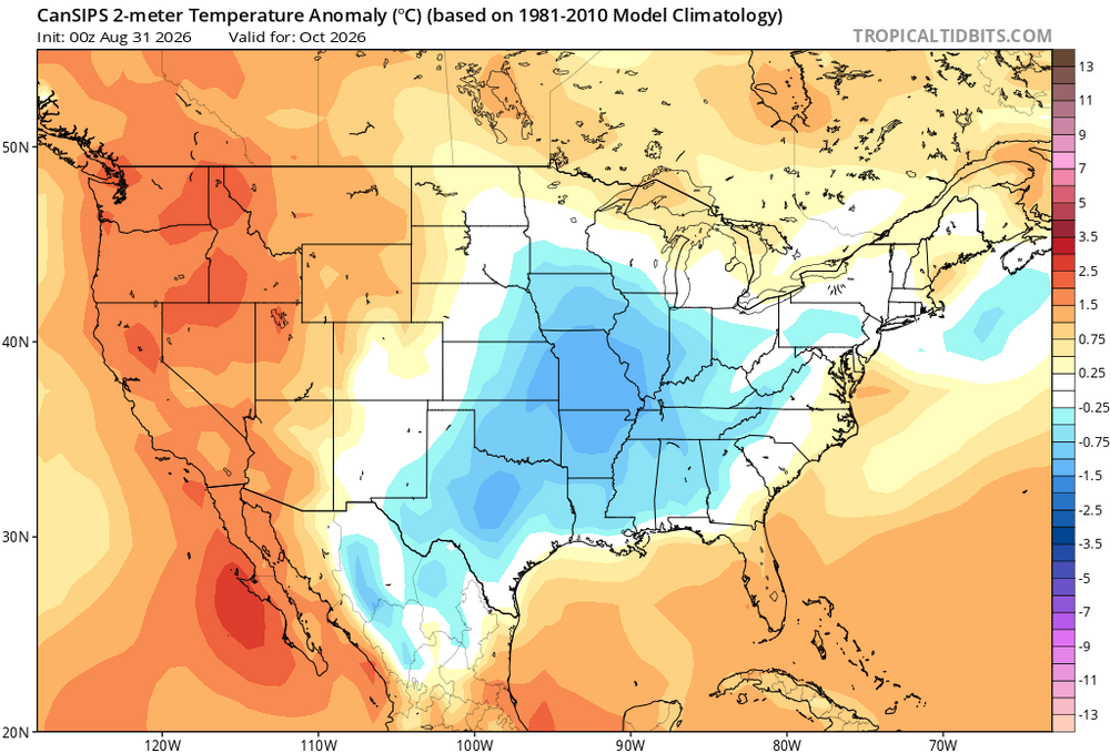
Parts of the CONUS are at +8 to +9 and it’s only October. None of the seasonal models were forecasting this from the September runs. Even the early October runs turned out too cool.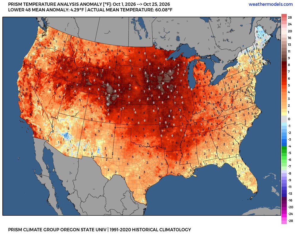
-

2026-2027 Record-breaking El Nino
A-L-E-K replied to Stormchaserchuck1's topic in Weather Forecasting and Discussion
racheted myself into a st louis climo -
GFS is the only model showing any meaningful precipitation next week. Tossed?
-

E PA/NJ/DE Autumn 2026 Obs/Discussion
ChescoWx replied to PhiEaglesfan712's topic in Philadelphia Region
10 of the 22 Chesco area stations most at relatively higher elevations have yet to record a below freezing temp. Here in EN I usually don't see a freeze till November and this year looks like no exception. Of note I receive the least amount of freezing days across these observation sites.
-
10 of the 22 Chesco area stations most at relatively higher elevations have yet to record a below freezing temp. Here in EN I usually don't see a freeze till November and this year looks like no exception. Of note I receive the least amount of freezing days across these observation sites.
-
2026-2027 Record-breaking El Nino
LakePaste25 replied to Stormchaserchuck1's topic in Weather Forecasting and Discussion
I don’t see the purpose of arguing with someone over and over if you disagree with their forecast. if someone forecasts december 2015, so be it. you can check back later and see if it verifies. Personally think a “super torch” outcome is more likely in the upper midwest instead of the NE because the STJ will extend much further eastward this time around, which means more coastal storms and ridge pushed more into Canada, both limiting factors. -

2026-2027 Record-breaking El Nino
40/70 Benchmark replied to Stormchaserchuck1's topic in Weather Forecasting and Discussion
I think we all are punting a cold and snowy December, but it's important to keep it real, too. -
 Plus increased cloud cover from precip will cap the extremes a bit Sent from my SM-S176V using Tapatalk