All Activity
- Past hour
-
Yeah.. I was under my 5th severe warning of the year.. nothing close to severe so far. 2x it barely even rained. I think Baltimore does a little better with storms than I do, a few degrees in temp apparently makes a difference. This year it's ended up being more rain up here than lightning..
-
pathetic bust in dover as well. lightning to the NW originally, with a cloud base visible even in the dark with the city lights. Somehow, it managed to reform to the SE. not even a tenth.
-
dover force field. THE STORMS WERE RIGHT THERE
-
Skunked today. Storms north, south,and east.
-

2025 Atlantic Hurricane Season
Boston Bulldog replied to BarryStantonGBP's topic in Tropical Headquarters
Track accuracy and cone narrowing from the NHC is probably the most noticeable improvement that has taken place in the past 20 years, take a look at what the cone looked like for Katrina when it entered the Gulf. Every bit of resolution for data matters immensely. Microwave data for track accuracy with numerical modeling has also taken gigantic strides. Losing a reliable ability to place the exact center with high resolution (in the absence of in-situ radar and hurricane hunter data) will certainly have repercussions down the temporal dimension of outputs. Intensity still remains the lowest verified forecast variable, which is no surprise given its stochastic nature. It will get so much worse without as frequent “under the hood” looks at the structure, especially as the observed increase in RI events globally continues. -
Beautiful outside 66F with a slight breeze.
-
I would say that all the analogs from 16-17 on have 2x the weight of one's before it. Recent, non-strong ENSO probably 3x (18-19, 19-20, 22-23, 24-25)
-
Nice course, used to play there quite a bit.
-
My lawn, landscaping, and garden are very happy.
-
One of those pulse ups gave me 0.26" of rain w/ 10-20 mph wind gusts. No lightning.
-
2025-26 is going to be a snowFULL FREEZE.
- Today
-
Outflow boundary almost here. About to get some withering Iowa sloppy seconds.
-
Saturday looks toasty on this NAM run
-
Congratulations, Everyone in the Mid Atlantic. Enjoy this. Stay safe.
-
So monitoring/predicting rapid intensification is worth nothing? Yeah, no. Intensity forecasting is the more difficult aspect of TC forecasting compared to track.
-
Story of the past 2 weeks
-
I’ve never seen lightning like this before. It’s constant.
-
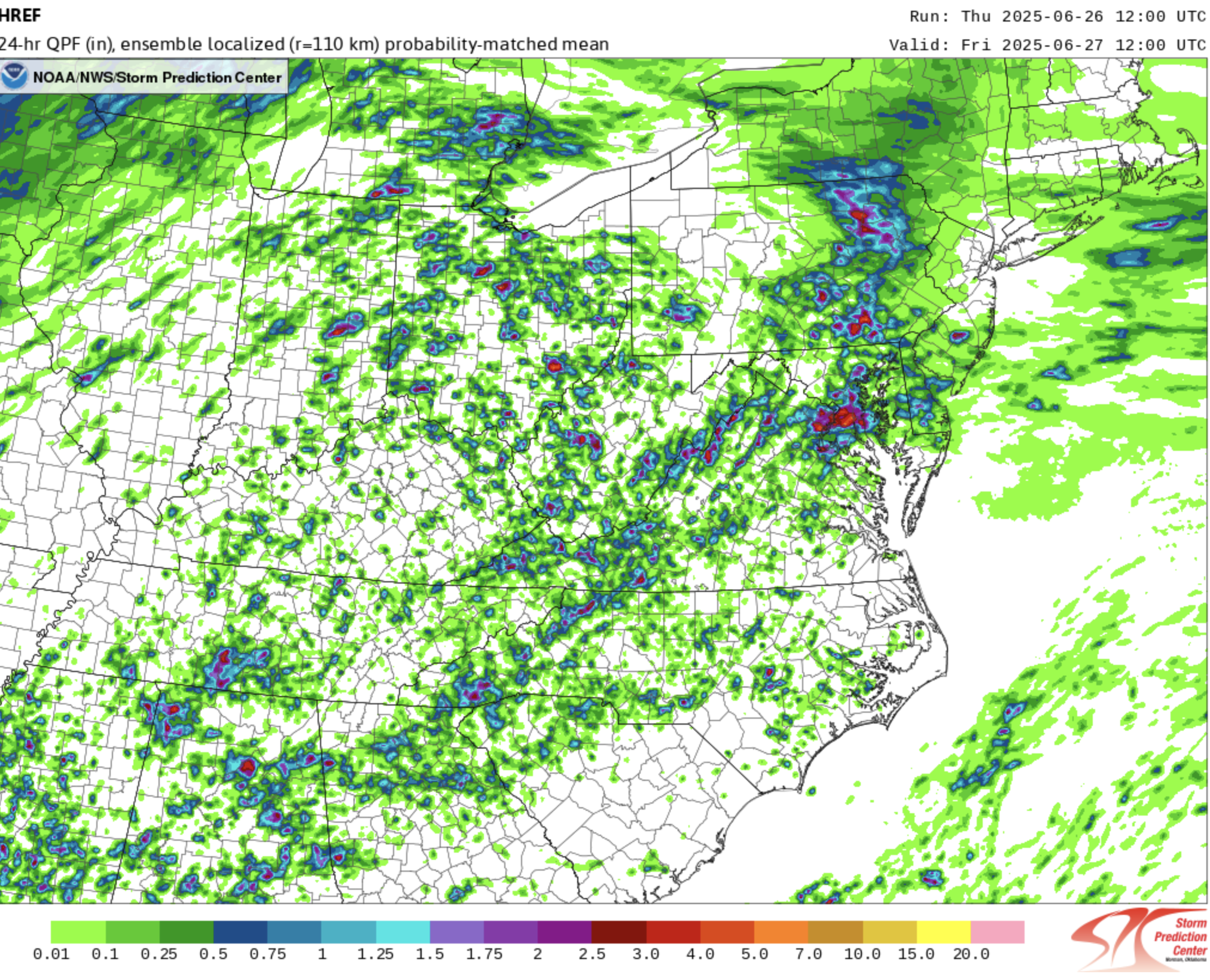
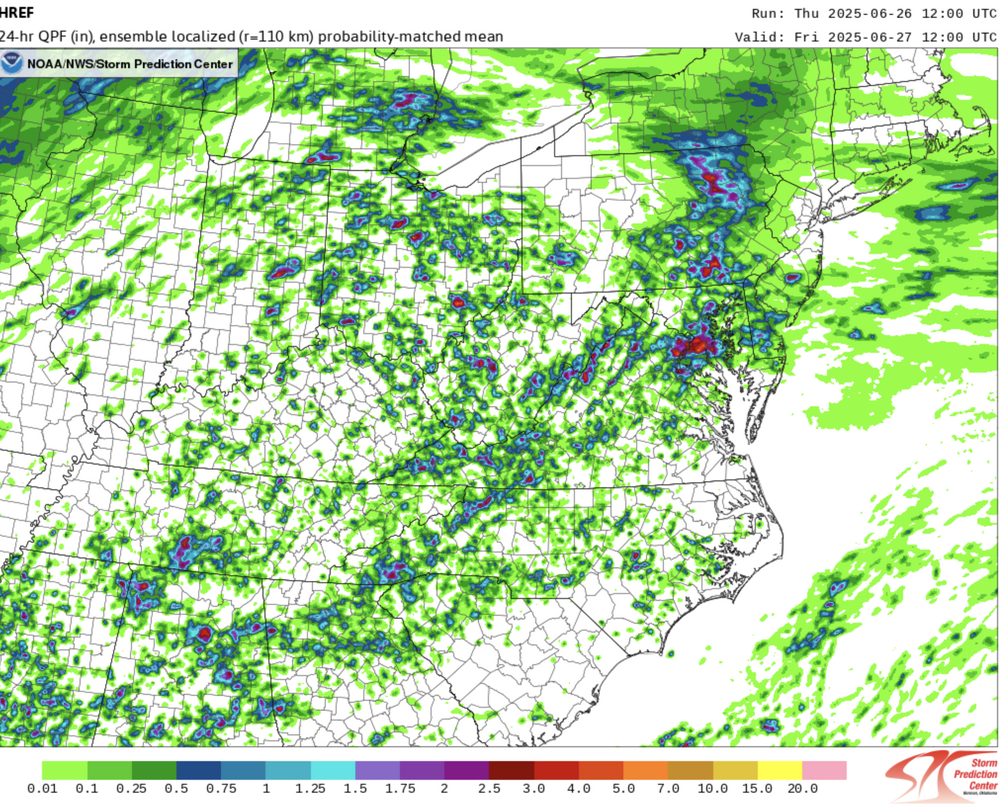
LWX issued their flood watch based at least partially on the HREF, which is going to end up doing very well highlighting the area of heaviest rain:
-
63/57…opening windows.
-
This has been a repeat of yesterday’s storm, moving north to south. Same areas in Calvert getting crushed again.
-
0.42 happy I didn’t get skunked
-

July 2025 Obs/Disco ... possible historic month for heat
512high replied to Typhoon Tip's topic in New England
Well said, he also does this during the winter months as a few others do as well. However, I hope he is wrong about historic type of heat….. -
Grade A heat wave with vitamin loaded humidity levels appears to be on its last leg. I still got my outdoor activities in, but definitely in smaller doses. Today felt spicy in the sun…no storms around here, though I have seen some “heat lightning”.
-
How likely is a 19-20, 22-23 redux? I only ask because I have a theory that starting with 2016-17 every 3rd winter is a snowless torch.
-

2025 Atlantic Hurricane Season
Stormchaserchuck1 replied to BarryStantonGBP's topic in Tropical Headquarters
More data is always better.