All Activity
- Past hour
-
5-6pm would be great trying to spend the day in Manhattan
-
Records: Highs: EWR: 89 (2007) NYC: 87 (2007) LGA: 89 (2007) JFK: 90 (2007) Lows: EWR: 32 (1935) NYC: 37 (1988) LGA: 40 (1988) JFK: 40 (2001) Historical: 1871 - Prolonged drought and dessicating winds led to the great Chicago fire, the Peshtigo horror, and the Michigan fire holocaust. Fire destroyed more than seventeen thousand buildings killing more than 200 persons in the city of Chicago, while a fire consumed the town of Peshtigo WI killing more than 1100 persons. In Wisconsin, a million acres of land were burned, and in Michigan, 2.5 million acres were burned killing 200 persons. "Tornadoes of fire" generated by intense heat caused houses to explode in fire, and burned to death scores of persons seeking refuge in open fields. (David Ludlum) (The Weather Channel) 1871: The Great Chicago Fire burns much of the city to the ground, fanned by strong southwest winds. An estimated 250 were killed. On the same night, forest fires swept through Peshtigo, Wisconsin. An estimated 1,500 to possibly as many as 2,500 dies as gale-force winds push flames across town. Severe drought blamed for tinder-dry conditions. 1878: An estimated F3 tornado struck Monticello, Iowa, around 5:30 pm. The Catholic Church was demolished, along with several homes. The business portion of the town was comparatively uninjured. While no lives were lost, 11 people were injured. The German Church in Richland township was destroyed, along with other buildings in the surrounding county. A wind and hail storm occurred during the evening hours in Sigourney, Iowa, causing considerable damage. Fences and shade trees were blown down, and much glass was broken by hail, which fell in large stones. 1901 - A deluge at Galveston, TX, produced nearly twelve inches of rain in about a six hour period. The rains came precisely thirteen months after the day of the famous Galveston hurricane disaster. (David Ludlum) 1919: An intense tornado moved through the town of Hoisington, 11 miles north of Great Bend, Kansas. It damaged or destroyed 60 homes which resulted in $200,000 in damages. Business papers and canceled checks were found at Lincoln, 55 miles to the northeast. 1946: A minimal Category 1 hurricane made landfall over Bradenton, Florida, before tracking north-northeast across Tampa Bay. The storm was the last hurricane to make direct landfall in the Tampa Bay area. 1972: Panama City, Florida: A cold front passing across Florida produces a tornado in Panama City that brings down power lines and blows out windows. (Ref. WxDoctor) 1982 - An unusually early snowstorm hit the northern Black Hills of Wyoming and South Dakota. The storm produced up to 54 inches of snow, and winds as high as 70 mph. The snowfall was very much dependent upon topography. Rapid City, 20 miles away, received just a trace of snow. (The Weather Channel) 1987 - Unseasonably cold weather prevailed from the Upper Mississippi Valley to the southeastern U.S. Thirty cities reported record low temperatures for the date, including Madison WI with a reading of 22 degrees. The low of 28 degrees at Evansville IN was the coolest of record for so early in the season. Hot weather continued in the southwestern U.S. Phoenix AZ reported a record high of 104 degrees and a record tying 116 days of 100 degree weather for the year. Tucson AZ established an all-time record with 72 days of 100 degree weather for the year. (The National Weather Summary) 1988 - Snow was reported across parts of northern New England. Two inches blanketed Mount Snow VT. Warm weather continued in the northwestern U.S. The afternoon high of 80 degrees at Stampede Pass WA exceeded their previous record for October by seven degrees. (The National Weather Summary) 1989 - Morning lows in the 20s were reported from the Northern Plains to the Upper Great Lakes. International Falls MN and Marquette MI reported record lows of 22 degrees. Unseasonably warm weather prevailed in central California as the Oakland Athletics won the American League pennant. San Luis Obispo CA reported a high of 99 degrees. (The National Weather Summary) 1993: With 1.05 inches of rain that fell at Columbia, MO, the yearly total precipitation was pushed to 55.77 inches, breaking the annual record. (Ref. Wilson Wx. History) 1996: Annandale Barcroft Hills Weather Center 1.88 inches of rain from Tropical Storm Josephine as it passed to our east. Hurricane Josephine's Track - Weather Underground 1999: Isolated thunderstorms caused significant accumulations of hail in southwest Oklahoma and northwest Texas. Hail fell up to 30 minutes in a swath from Gould to near Duke, Oklahoma; rain-drifted hail to depths of 3 feet in ditches. Hail cumulated 6 inches south of Cooperton, Oklahoma, and 8 inches near Lockett, Texas. (Ref. Weather Guide Calendar with Phenomenal Weather Events 2012 Accord Pub. 2011, USA) 2000: The coldest pre-October 10th air mass in nearly 50 years has invaded the central United States!!! The cold was most impressive over Texas. San Antonio only reached a high temperature of 46 degrees October 8,2000. This set a low-maximum temperature for the date. The previous record was 65 set in 1975. The normal high in San Antonio is 84. A 111-year-old record was broken Sunday morning October 8th in Memphis, Tennessee, when the temperature fell to 36 degrees (the previous record was 39 degrees set in 1889). (Ref. Wilson - Additional Temperatures Listed On This Link) 2001: Hurricane Iris made landfall S of Belize City, Belize (on SE section of the Yucatan Peninsula); sustained winds of 145 mph; storm surge to 15 feet. The M/V Wave Dancer, charted by the Richmond (VA) Dive Club, sank at Big Creek. 17 of 20 dive club members on board died; 3 crew members also died. (Ref. Weather Guide Calendar with Phenomenal Weather Events 2011 Accord Pub. 2010, USA) 2005: The Annandale Weather Station maximum rain in a 24-hour period is 5.66 inches which was set on October 7th and 8th 2005. (Ref. Annandale Weather Records) 2018: Hurricane Michael Panama City, Florida Hurricane Michael was a historic hurricane on several counts - Hurricane Michael made landfall Wednesday October 10th as an unprecedented high-end Category 5 hurricane (on the Saffir-Simpson Scale) along the Florida Panhandle region with a maximum sustained wind speed of 155 mph at landfall and a minimum air pressure of 919 mb (27.14 inches of mercury). In terms of central barometric pressure, Michael was the third most powerful hurricane to strike the U.S. mainland, ranked behind the unnamed Labor Day Hurricane of September 1935 (892 mb) and Hurricane Camille (900 mb) in August 1969. However, Michael's central pressure was the lowest on record for any October hurricane to strike the United States. In terms of maximum sustained wind speed at landfall, Michael was the fourth strongest, behind the Labor Day 1935 hurricane (184 mph), Hurricane Camille (172 mph) and Hurricane Andrew in 1992 (167 mph). Michael is the first Category 5 hurricane on record to make landfall on the Florida Panhandle with (160 mph winds).
-
Looks like it's trying to wrap some deep convection around the west side of the eye. If it can hold on and build an eyewall out of this, that's it's shot.
-
I would expect one more significant ramp up tonight before it hits the shredder Tommorow
-
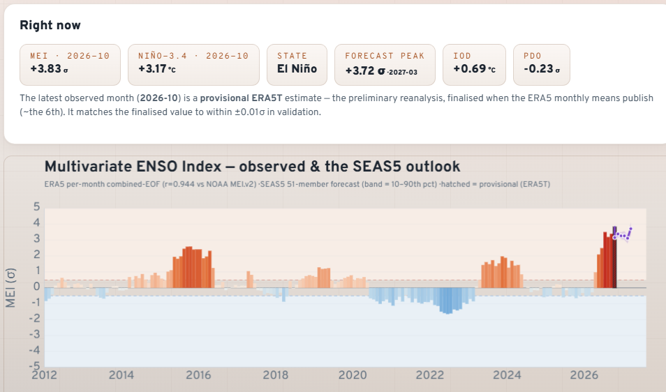
Least we are starting to see the the PDO changing for that matter as well so is the IOD,IOD should be warmer in a strong NINO
-
Recon seems supportive of 80 kts, closing in on cat 2 at a much more modest rate today
-
Looks like a legit eye to me but it’s only cleared out bc the convection waned and isn’t overshooting it from the SW I believe. Looks legit now
-
My gut maybe right after all with the way the QPF keeps lowering here in the piedmont. Jesus we cant get anything right here except for drought and humidity/heat.
-
 Over the counter antibiotics pills and antibiotics over the counter over the counter antibiotics pills http://fotos24.org/url?q=https://antibiodirect.com generic antibiotics online cheap and http://clubdetenisalbatera.es/user/gezasxljnx/ antibiotics online prescription [url=http://www.3721cha.com/alexa/Index.asp?url=antibiodirect.com]otc antibiotics[/url] buy zithromax antibiotic or [url=http://jonnywalker.net/user/jwlombpzhv/]Over the counter antibiotics pills[/url] online antibiotics
 -
We've had measurable rain on 3 of 8 days this month, which would project 137 such days per year, only 7 days less than average (average precip is 48.83)". Total precip is 0.06" - totaling 2.74" for the year. No wonder the Sandy River is in the bottom 10% and Carrabassett in the bottom 5%. The upper halves of trees here are 90% de-leafed. Lower half about halfway. Today's wind hasn't been grabbing much foliage so far.
-
I would think tonight’s its last chance to ramp up. It’s clearly struggling already with dry air and shear. Looks elongated already.
-

Central PA Autumn 2026
Itstrainingtime replied to canderson's topic in Upstate New York/Pennsylvania
Total expected rainfall from WPC is yet another reduction: -
My expectation for most of the piedmont is 1" but I would not be surprised in the coastal convection robbed even more moisture and there is a screw zone of like 1/2" between here and PTI
-
That’s good news if it holds for those threatened. Hopefully shear will do its thing and keep it struggling. But it looks like it will probably still be a hurricane when it comes in and thus be no picnic for them.
- Today
-
(002).thumb.png.6e3d9d46bca5fe41aab7a74871dd8af8.png) Hello all. Announcing something new on chescowx.com...ChescoWx Studies! This is an ongoing series looking at what makes Chester County's climate unique, this will include deep analysis of climate patterns and cycles, weather monitoring equipment and tools and past storm write ups and details. Each study takes one question, tests it against our station records and gives you the answer with the numbers behind it. I would welcome any feedback or pushback on the methods or the results. The series lives here and will grow as new studies are finished: https://chescowx.com/chescowx-studies/ Study 1 - Equipment & Siting. Three stations at my place in East Nantmeal. A ground-level fan-aspirated Davis, a rooftop Tempest and a ground-level Ambient with a passive shield. The Tempest highs ran about +3°F in July through September and +3.3°F on sunny, calm days, with 45 days of 90°F vs 8 for the Davis. To separate the roof from the shield, I looked at the Ambient. From 2021 to 2023 its summer highs matched the Davis within a few tenths while the Tempest was +2.8°F...so it is the roof, not the shield. Once the Ambient shield was damaged, though, it ran almost 7°F warm on sunny days. Location first, then upkeep. Study 2 - Elevation & Terrain. Most of our hilltop stations came along decades after the valley ones, and the weather varies from one decade to the next, so I compared them over the same years (2012 to 2025) using USGS 3DEP elevations. 19 stations with at least 8 complete years, by band: 100 to 300 ft (4 stations): high 64.4, low 43.6, 90 degree days 19, freezing nights 111, growing season 182 days 300 to 600 ft (8 stations): high 63.3, low 44.5, 90 degree days 11, freezing nights 101, growing season 192 days 600 ft and up (7 stations): high 62.3, low 45.3, 90 degree days 9, freezing nights 94, growing season 204 days Days follow elevation and nights follow terrain position. Highs drop about 1.7°F for every 300 ft, but lows track how far a station sits above its immediate surroundings, which is why they actually rise as you go up. For snow I used a same-storm comparison (521 storms, 60+ human-observed sites) so a snowy decade at one station does not skew it. Overall the hills get about 8% more snow for every 300 ft (29% per 1,000 ft), but the time of season matters a lot: Oct-Nov (24 storms) about 25% per 300 ft Dec-Jan (251 storms) about 6% Feb (151 storms) about 5% Mar-Apr (95 storms) about 18% March 2004 is a good example: East Nantmeal 11.0, Coatesville 2W 8.8 vs Exton 3.0, Chadds Ford 3.4, West Chester 2.2. There are always a few sites that do not fit, and the southern uplands around West Grove and New London run less than their elevation would suggest. The north also gets a bit more than the south, while the western part of the county gets more only because it is higher. Precipitation showed no elevation effect at all. Let me know if any questions, if you see anything that does not hold up, or if there is a question you would like to see tested next!
Hello all. Announcing something new on chescowx.com...ChescoWx Studies! This is an ongoing series looking at what makes Chester County's climate unique, this will include deep analysis of climate patterns and cycles, weather monitoring equipment and tools and past storm write ups and details. Each study takes one question, tests it against our station records and gives you the answer with the numbers behind it. I would welcome any feedback or pushback on the methods or the results. The series lives here and will grow as new studies are finished: https://chescowx.com/chescowx-studies/ Study 1 - Equipment & Siting. Three stations at my place in East Nantmeal. A ground-level fan-aspirated Davis, a rooftop Tempest and a ground-level Ambient with a passive shield. The Tempest highs ran about +3°F in July through September and +3.3°F on sunny, calm days, with 45 days of 90°F vs 8 for the Davis. To separate the roof from the shield, I looked at the Ambient. From 2021 to 2023 its summer highs matched the Davis within a few tenths while the Tempest was +2.8°F...so it is the roof, not the shield. Once the Ambient shield was damaged, though, it ran almost 7°F warm on sunny days. Location first, then upkeep. Study 2 - Elevation & Terrain. Most of our hilltop stations came along decades after the valley ones, and the weather varies from one decade to the next, so I compared them over the same years (2012 to 2025) using USGS 3DEP elevations. 19 stations with at least 8 complete years, by band: 100 to 300 ft (4 stations): high 64.4, low 43.6, 90 degree days 19, freezing nights 111, growing season 182 days 300 to 600 ft (8 stations): high 63.3, low 44.5, 90 degree days 11, freezing nights 101, growing season 192 days 600 ft and up (7 stations): high 62.3, low 45.3, 90 degree days 9, freezing nights 94, growing season 204 days Days follow elevation and nights follow terrain position. Highs drop about 1.7°F for every 300 ft, but lows track how far a station sits above its immediate surroundings, which is why they actually rise as you go up. For snow I used a same-storm comparison (521 storms, 60+ human-observed sites) so a snowy decade at one station does not skew it. Overall the hills get about 8% more snow for every 300 ft (29% per 1,000 ft), but the time of season matters a lot: Oct-Nov (24 storms) about 25% per 300 ft Dec-Jan (251 storms) about 6% Feb (151 storms) about 5% Mar-Apr (95 storms) about 18% March 2004 is a good example: East Nantmeal 11.0, Coatesville 2W 8.8 vs Exton 3.0, Chadds Ford 3.4, West Chester 2.2. There are always a few sites that do not fit, and the southern uplands around West Grove and New London run less than their elevation would suggest. The north also gets a bit more than the south, while the western part of the county gets more only because it is higher. Precipitation showed no elevation effect at all. Let me know if any questions, if you see anything that does not hold up, or if there is a question you would like to see tested next! -
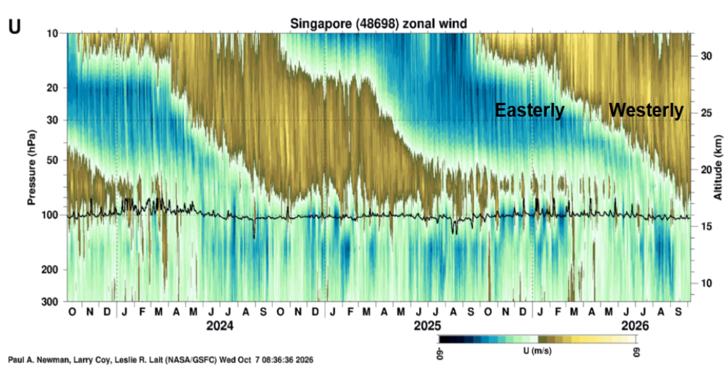
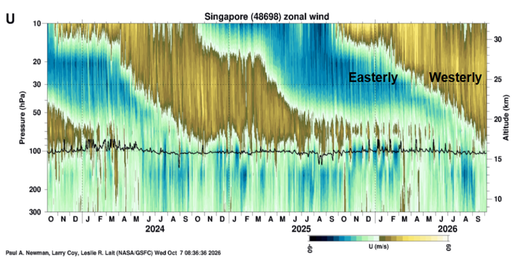
I haven't looked at the QBO in a while, but it's bearish. Note that most of us agree it's not very reliable, so take it with less than a grain of salt.
-

Brownsville Experiences Hottest September on Record
GaWx replied to donsutherland1's topic in Climate Change
Do you have it for OK? -
Capital Weather latest forecast for Sunday. https://www.capitalweather.com/how-will-tropical-storm-isaias-affect-the-dc-region-this-weekend/
-
Been on the same pattern since yesterday of convection really dying off during diurnal minimum but coming back with a vengeance overnight
-
Go take the super niño and push it somewhere else
-
https://auroramedsdirect.com/# certified canadian international pharmacy
-
Cloud tops warmed pretty quick. This system is definitely struggling right now.
-
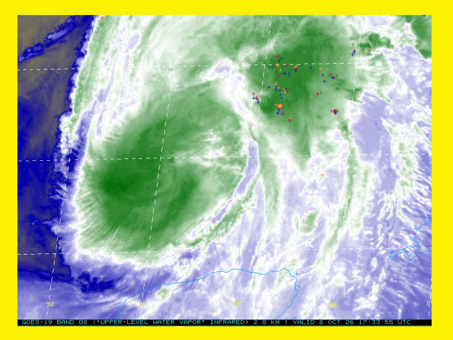
I don't see an "EYE". Just hallucinations with convection sheared well to the NE. I named this sat capture as GONZO
-
They updated it not long ago and cut back central NC from this:
-
https://antibiodirect.com/# generic antibiotics