All Activity
- Past hour
-

Central PA Fall Discussions and Obs
Blizzard of 93 replied to ChescoWx's topic in Upstate New York/Pennsylvania
6z GFS shows 2 chances of snow this run between the 4th & 6th. Enjoy it for 6 hours… but hopefully this is the beginning of tracking season.
-
I don’t want to jinx you but it’s looking like a very good call on your part with the SPV, along with the increasingly likely flip to RNA in December
-

2025-2026 ENSO
40/70 Benchmark replied to 40/70 Benchmark's topic in Weather Forecasting and Discussion
Problem is that today not enough people are concerned with thinking critically.... and just want to generate clicks on social media while touching themselves to red colors near the North Pole. -
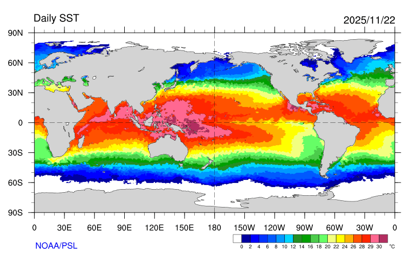
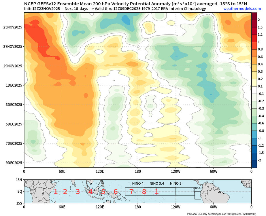
Thanks for the kind words. I really enjoy our discussions over the years. My guess is that the reason for both the CCKW and MJO activity following the pattern we have been describing is the extensive +28 to +30C warm pool near the 6-7 zones on the chart that you posted. So this has been causing the looping activity on the RMM charts that we have been frequently observing over recent years. The CCKW and MJO interaction could also be why we are seeing these stronger Southeast ridge patterns than just using a straight MJO 7 composite. I was hinting at this in our recent conversation on the MJO 7 composites. Perhaps these composites lose some effectiveness since the sample size of events is smaller and merged with the CCKW interactions which has been more recent as the WPAC warm pool has been expanding. So when the forcing stalls closer to the 6-7 regions, it delays the passage into Phase 8 like we have seen so often since February 2022. Plus the continuing 6-7 area convection interferes with the typical MJO 8 composites like last January when the Pacific Jet remained rather strong due to the lingering forcing there in concert with the very strong SST gradient over the midlatitude Pacific to the east of Japan and south of the Aleutians.
-
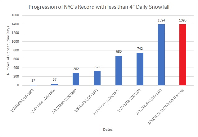
From xmACIS. We're years away from the 3" record (289 days vs. record of 1,110 days); 6" record (1,395 days vs. record of 2,572 days); and, 10" record (1,757 days vs. record of 3,266 days). https://xmacis.rcc-acis.org/
-
2025-2026 ENSO
40/70 Benchmark replied to 40/70 Benchmark's topic in Weather Forecasting and Discussion
There is a reason most +TNH reflection events occur in January/February, and major SSWs that include a zonal wind reversal are exceedingly rare in December. It's not a coincidence at all. -
2025-2026 ENSO
40/70 Benchmark replied to 40/70 Benchmark's topic in Weather Forecasting and Discussion
It was clear as day looking at analogs that this would be a reflection event...should get mild for early January, and then go +TNH with a stout PV by mid month. The real SSW should come after that...probably second week of February. -

Pittsburgh PA Fall 2025 Thread
Gordo74 replied to TheClimateChanger's topic in Upstate New York/Pennsylvania
Looks like the cool down keeps getting bumped just to the horizon of the 10 day forecast and not lining up with precip. Ho hum. -
2025-2026 ENSO
40/70 Benchmark replied to 40/70 Benchmark's topic in Weather Forecasting and Discussion
Okay. Bump away...in fact, I'll probably save you the trouble. -
That's clearly some sort of anomalous error and not representative of normal. Most people I know IRL just use their apple weather app when they check the weather, they're not going to AccuWeather.com much less listening to the local news or looking at models. I can't think of the last time any person has ever talked to me about the weather forecast they saw on TV.
-
where did you get this data? and can you sort by other snowfall amounts, like 3" or 6" or 10"?
-
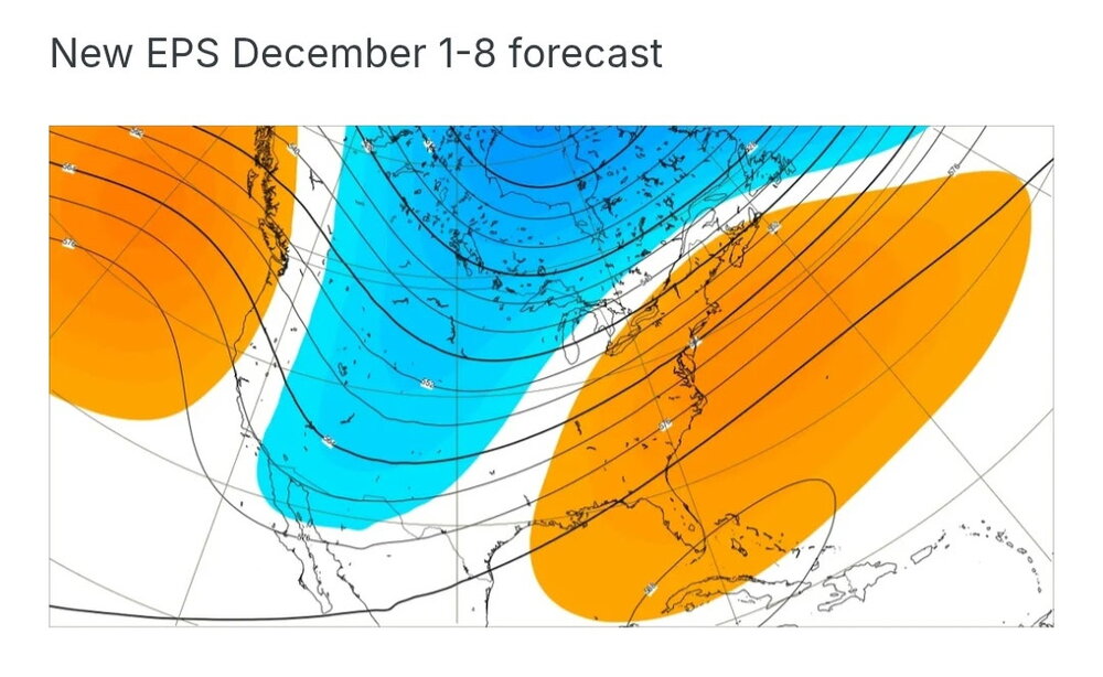
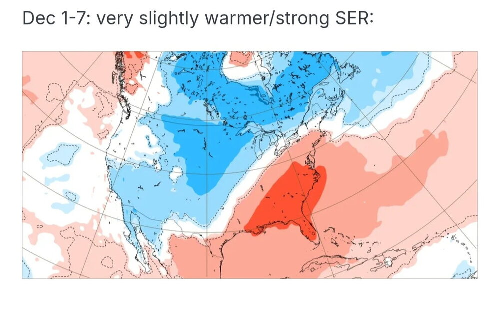
Euro weeklies yesterday vs new euro ensembles for the same week. Deamplying the ridge in the east. This is what we need.

-
Not really, worst possible scenario is the torch. A torch at Christmas is the equivalent of stubbing my toe at 3am. So you can keep that foolishness to yourself. Haha
-
Festive if anything, to open the holiday season. Maybe a whitening on the newly strung garland and lighting. Beats 62 and open golf courses in my world. LATE FRIDAY NIGHT THROUGH SATURDAY, A POTENTIALLY PROLONGED PERIOD OF WARM ADVECTION DRIVEN PRECIPITATION PAIRED WITH SUFFICIENTLY COLD TEMPS ALOFT AND AT THE SURFACE MAY SET THE STAGE FOR AN ACCUMULATING SNOW EVENT. WHILE THERE'S A LARGE SPECTRUM OF PLAUSIBLE OUTCOMES AMONGST ENSEMBLE MEMBERS, THE MULTI-ENSEMBLE PROBABILITY FOR 1"+ (10:1) SNOWFALL IN 24 HOURS CENTERED ON SATURDAY-SATURDAY EVENING IS >=60% EVEN AT THIS EXTENDED LEAD TIME. THE ECMWF/EPS DEPICTION HAS BEEN GENERALLY MORE ROBUST THAN THE OTHER GUIDANCE SUITES, BUT ULTIMATELY IT'S MUCH TOO FAR OUT FOR SPECIFICS, ASIDE FROM FEELING COMFORTABLE WITH ~60% POPS IN THE GRIDDED FORECAST. OUR MAIN MESSAGE IS TO KEEP A CLOSE EYE ON SUBSEQUENT FORECAST UPDATES AS THIS TIMEFRAME DRAWS CLOSER FOR THE POTENTIAL FOR WINTER WEATHER IMPACTS TO POST-THANKSGIVING TRAVEL. -LOT
-

Central PA Fall Discussions and Obs
mahantango#1 replied to ChescoWx's topic in Upstate New York/Pennsylvania
Just great...more wind! -
 Only looked real quick on phone but next couple weeks look windy? Storm track to west and north of region = CAA.
 -
Too soon. Let the hope and hype build for another 48-72 hours before you crush dreams.
-

2025-2026 ENSO
PhiEaglesfan712 replied to 40/70 Benchmark's topic in Weather Forecasting and Discussion
December 2021 was a very warm December in the Eastern US (I think only 2015 was warmer). If we're not going to get any snow in December, then I hope it's a torch. At least it can come back to average at some point in the winter (like January 2022). The worst possible outcome is a cooler December with no snow (like December 2022). -

November 2025 general discussions and probable topic derailings ...
dendrite replied to Typhoon Tip's topic in New England
Currently 32.3° with some snow melting. Min was 29° shortly after midnight. -
This is unbelievable. Thank you for doing this.
-

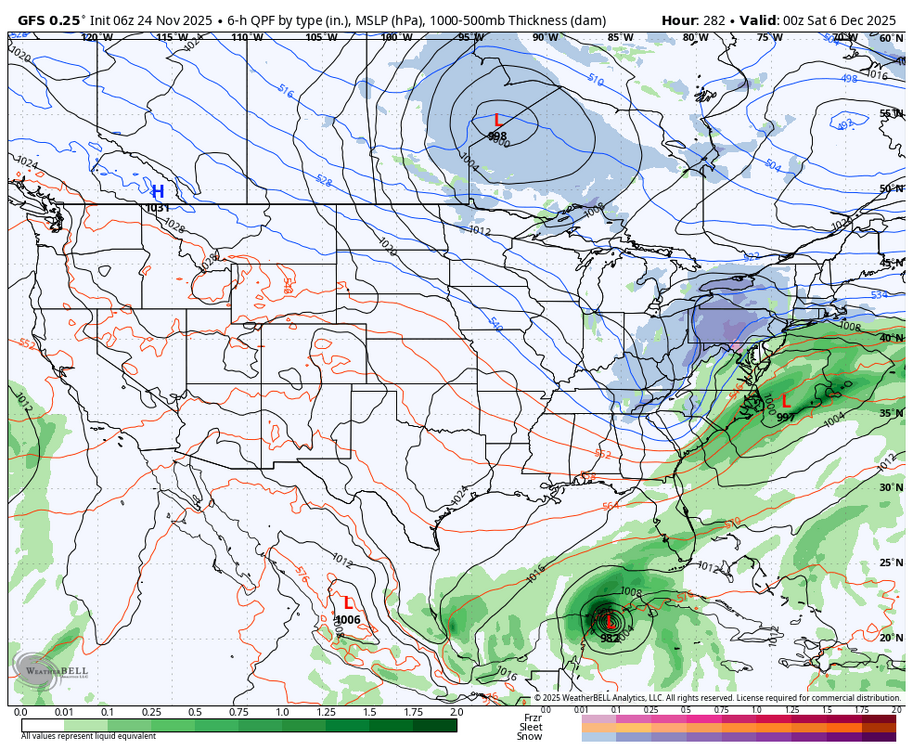
December 2025 Short/Medium Range Forecast Thread
Carvers Gap replied to John1122's topic in Tennessee Valley
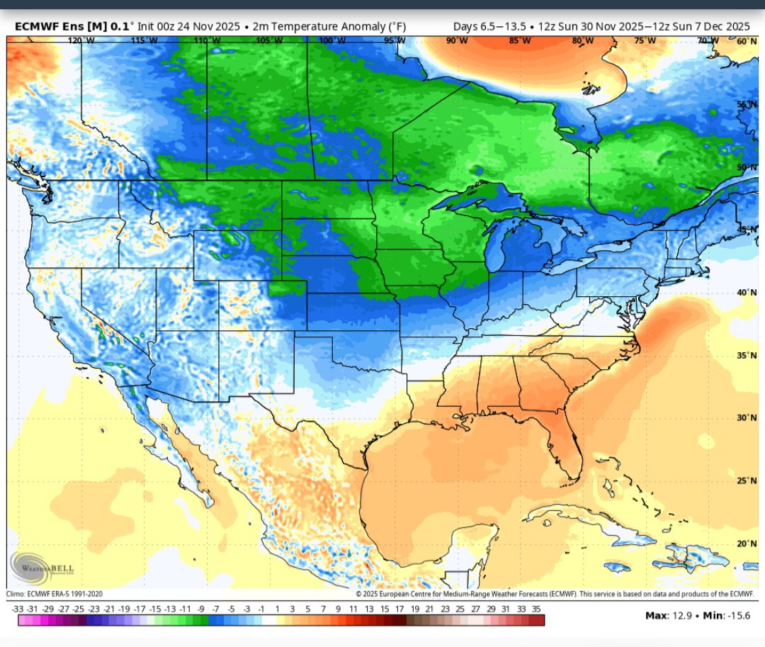
The difference between 0z and 6z on the GFS is stark regarding the long range pattern. I think it likely we deal with warm temps through the first week of December, but that is not set in stone as there is a cold front possibly coming through Dec 6th(up in the air so to speak). -
Today will be New York City's (Central Park) 1,395th consecutive day without a 4" (10.2 cm) or above daily snowfall. That will break the record of 1,394 days that was set during February 22, 1929 through December 16, 1932.
-

November 2025 general discussions and probable topic derailings ...
Kitz Craver replied to Typhoon Tip's topic in New England
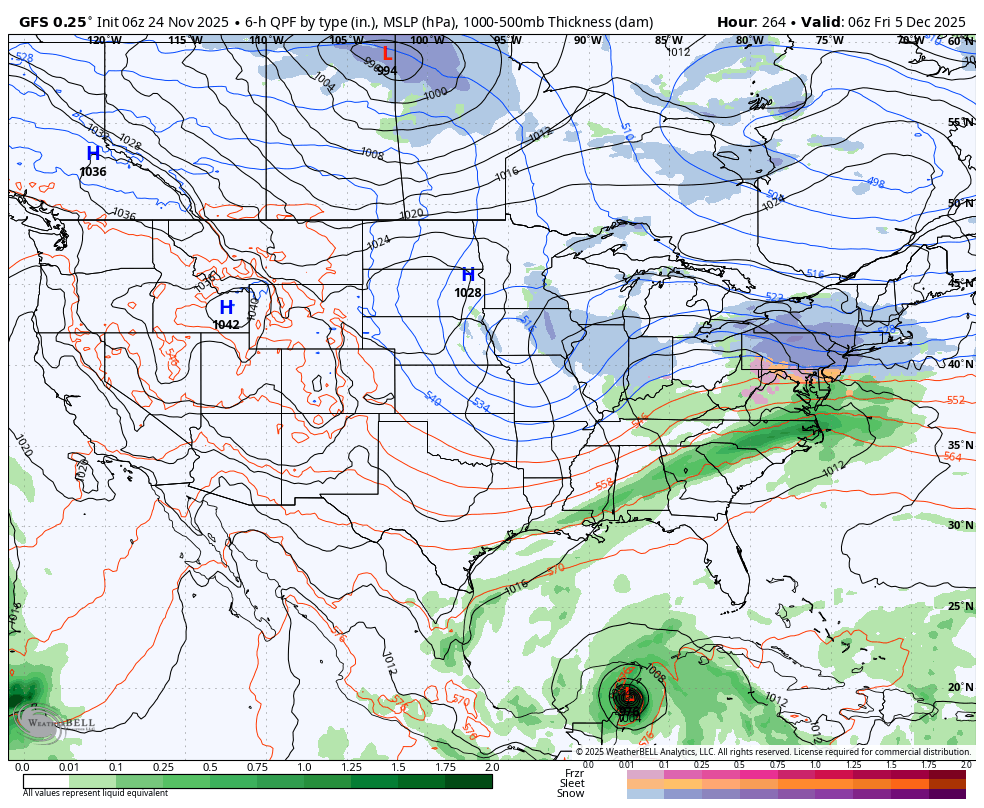
EURO and GFS going for a coastal around the 5th. I believe Ray said chance of one around that period - Today
-

2025-2026 ENSO
Stormchaserchuck1 replied to 40/70 Benchmark's topic in Weather Forecasting and Discussion
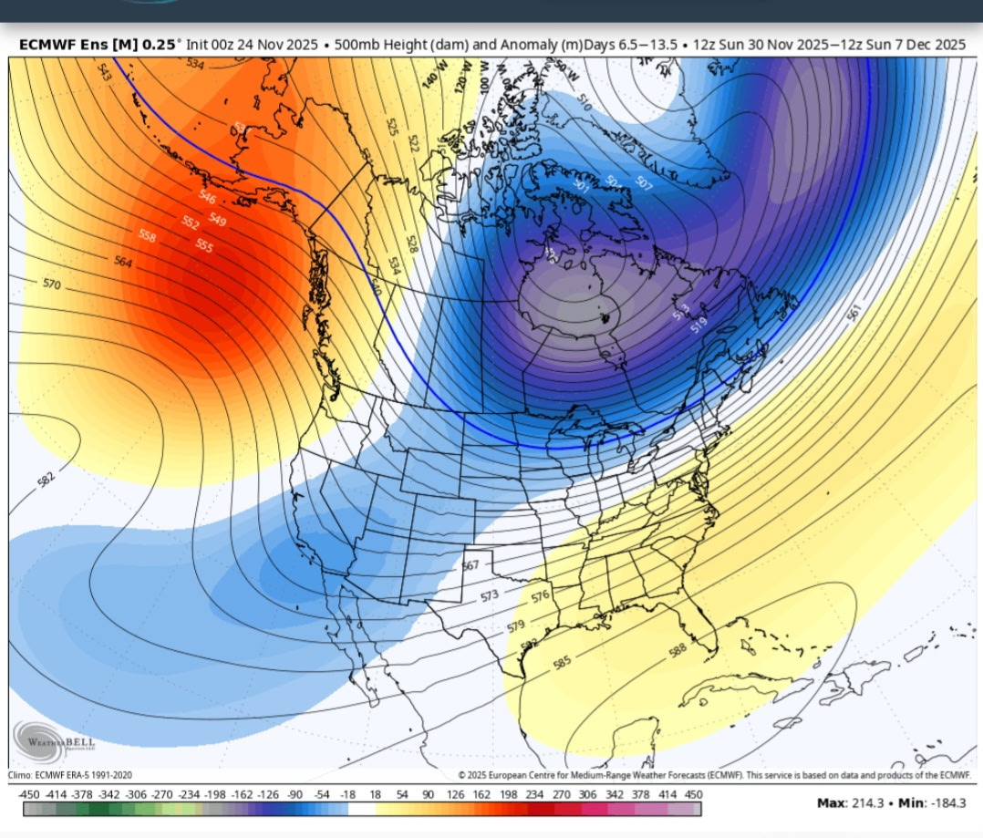
Dec 2021 was one of the strongest -PNA's.. what I see on models right now is a "moderate -PNA event" in early Dec. I also don't know that it sustains beyond like a week. We'll see. If it lasts into mid-December that would be a little different from what we have seen this year (where -PNA's last 7-10 days then go away). -
Boston, MA - 53” NewYork, NY(Central Park) - 27” Philadelphia, PA - 21” Baltimore, MD- 16” Washington, DC- 13” Albany, NY- 65” Hartford, CT - 61” Providence, RI- 40” Worcester, MA - 71” Hyannis, MA - 33” Burlington, VT - 93” Portland, ME- 75” Concord, NH - 69”