All Activity
- Past hour
-
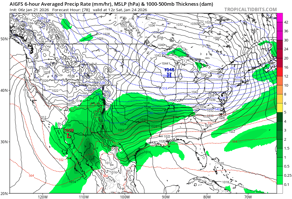
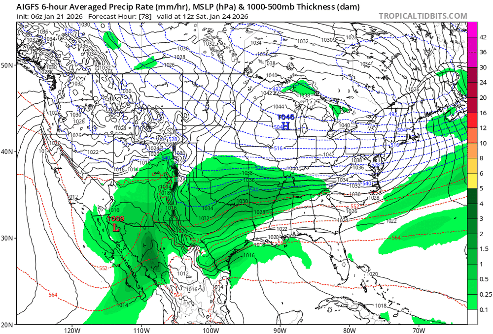
Here's the 06z gfs AI model notice the 540 (mix) line stays just south of DC very nice run!!
-
This is 1960s cold.
-

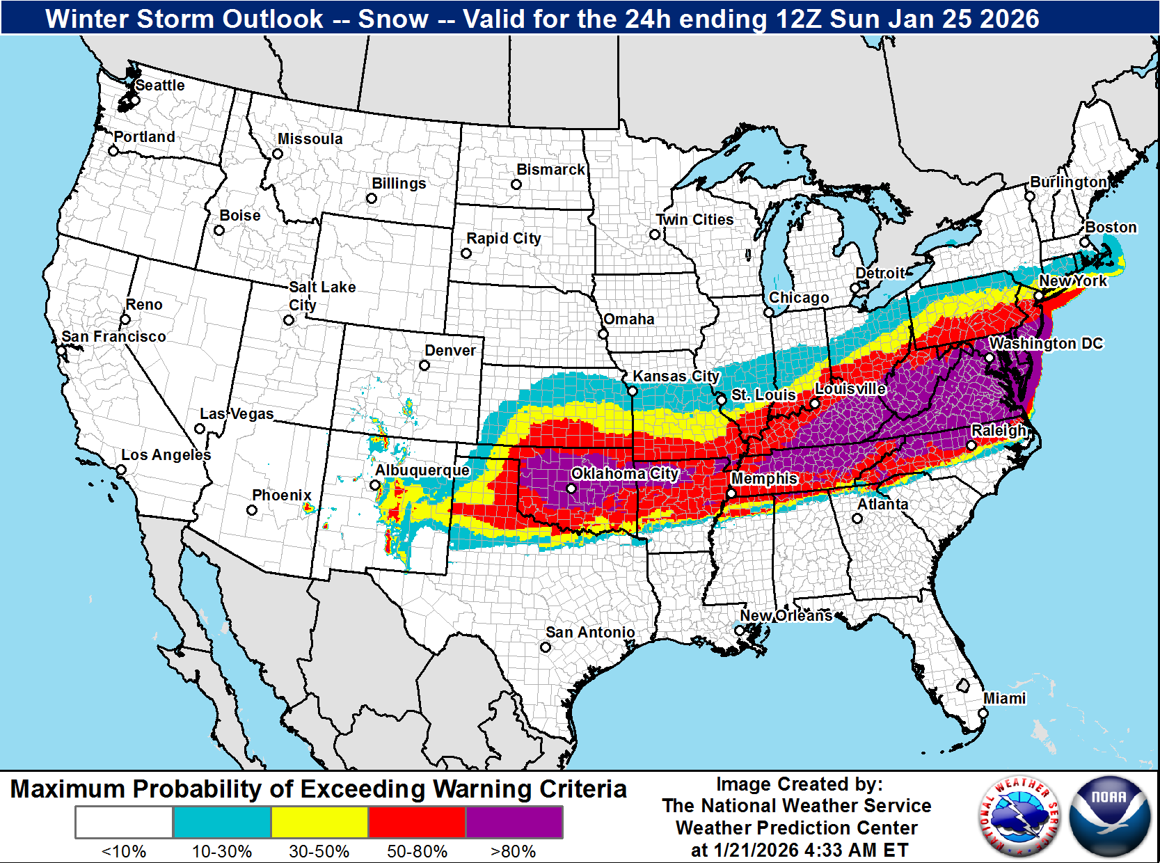
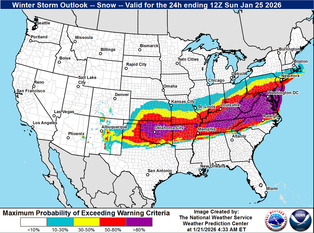
January 25/26 Jimbo Back Surgery Storm
NorthHillsWx replied to Jimbo!'s topic in Southeastern States
We’re 3 days out so my initial forecast calls: Triangle- <1” SN, 2-3” IP, 25-.30” ZR Triad- 1” SN, 3-4” IP, .10-.25 ZR Foothills- 1-3” SN, 4-5” IP, TR-0.10” ZR Charlotte- TR-1/2” SN, 2-3” IP, .25-.30” ZR Upstate- TR SN, 2-3” IP, .25-.40” ZR ATL- TR-1/2” IP, 0.25-0.40” ZR (cold rain to finish) NC coastal plain- TR-1/2” SN, TR-2” IP, .25-.75” ZR Could see some isolated heavier amounts to 1” ZR if temps stay in 20’s). Switches to rain at coast and inland by a county or two limiting accumulation in those areas. SC low country-Midlands-NC Sandhills- TR-2” IP (more north and west), .25-1” ZR possibly a few higher totals in Sandhills to NW of Columbia. Switches to rain after light icing along the coast. Think worst ice runs from Greenville NC to Fayetteville to newberry SC to Greenwood SC and a county on either side of that line as first guess. Could extend further into GA as well especially Athens to Gainesville Praying a lot in NC and upstate get a sleet bomb -
Whatever it takes to get 20"+!
-

January 2026 regional war/obs/disco thread
Damage In Tolland replied to Baroclinic Zone's topic in New England
It’s mainly northern 2/3 of CT north with 1-2” -
I wasn't expecting it to feel like upstate NY this morning here in the lowlands. My point and click confused me for a second. I thought i had to set on Lacona NY when I looked at the long range forecast. Awesome period of deep winter incoming. 10
-
1 at home, 16 in the bronx.
-
Currently 9. Better get used to this cause looks to be this cold or colder for a while.
-
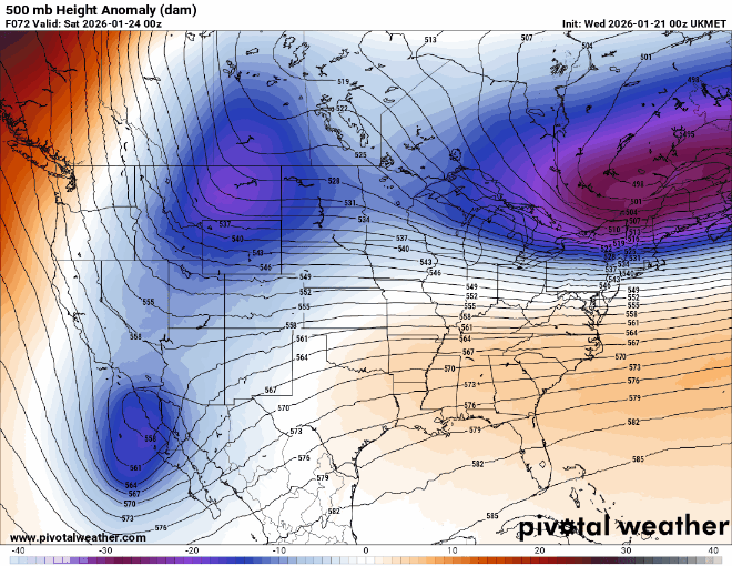
Uk shift at 06z. Not insignificant. Euro to follow?
-
EPS looks to be trending south. .
-

January 2026 regional war/obs/disco thread
Spaizzo replied to Baroclinic Zone's topic in New England
I don’t see many talking about tonight. Minus words alerting me yesterday afternoon snow Wednesday evening from 7-9pm lol . -
Pretty sure Apple weather is a bigger weenie than me… .
-
9. -2 at westhampton
-
-
The Will map should go out to about 130 for totals
-

Richmond Metro/Hampton Roads Area Discussion
RVASnowLover replied to RIC Airport's topic in Mid Atlantic
GEFS was great FWIW -
Got down to -23 that morning by me
-
As I get older and thinner this cold really just kills you at 530am. A few years ago this woukd be shorts and hoodie weather still. Now I'm in jeans, winter carhartt jacket and insulated gloves. 13 absolutely freezing degrees in Kearny, nj.
-
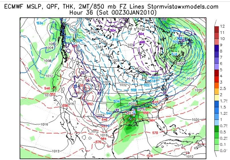
This storm is very similar to the late Jan 2010 storm. I had to go back to my archives but this is what the models showed then. This had less cold air to work with and we ended up with loads of sleet after an initial thump of snow. There was more confluence in the NE which def helped keep it south.
-
If this holds this is going to be a huge hit to the weather industry in terms of the social media group. Local Mets have been banging the drum against them for a while. This might be if not the death blow a big shot to the attention they get
-
You never want to jump in bed with satan!
-
+1.5 here
-

E PA/NJ/DE Winter 2025-26 Obs/Discussion
The Iceman replied to LVblizzard's topic in Philadelphia Region
3F outside, coldest of the season -
Hello from the TN Valley. I hope this helps some! .
-
Sitting at 4 below at the moment.