All Activity
- Past hour
-

November 2025 general discussions and probable topic derailings ...
dendrite replied to Typhoon Tip's topic in New England
Scoot: “Judah…I am your daddy” -
Below normal temperatures will prevail through tomorrow. Highs will be mainly in the middle and upper 40s in New York City with lows in the middle and upper 30s. A milder pattern will then develop afterward. Some rain or rain showers are possible. Once in place, the milder pattern will likely continue into the closing days of November. However, exceptional warmth appears unlikely. The closing days of November could turn cooler. Meanwhile, today will be Central Park's 1,390th consecutive day without daily snowfall of 4" or more. The record of 1,394 days was set during February 22, 1929 through December 16, 1932. That stretch ended with 6.7" daily snowfall on December 17, 1932. The ENSO Region 1+2 anomaly was -0.7°C and the Region 3.4 anomaly was -0.7°C for the week centered around November 12. For the past six weeks, the ENSO Region 1+2 anomaly has averaged -0.16°C and the ENSO Region 3.4 anomaly has averaged -0.65°C. La Niña conditions will likely continue through at least mid-winter. The SOI was +38.30 today. That is the highest SOI value since December 23, 2022 when the SOI reached +50.96. The preliminary Arctic Oscillation (AO) was -1.027 today. Based on sensitivity analysis applied to the latest guidance, there is an implied 74% probability that New York City will have a cooler than normal November (1991-2020 normal). November will likely finish with a mean temperature near 47.1° (0.9° below normal). Supplemental Information: The projected mean would be 0.6° below the 1981-2010 normal monthly value.
-
November 2025 general discussions and probable topic derailings ...
dendrite replied to Typhoon Tip's topic in New England
What will we get first? Epstein files GTA6 Consequential SSW -
Currently: Clear. Calm. 29.4°
-

November 2025 general discussions and probable topic derailings ...
WinterWolf replied to Typhoon Tip's topic in New England
Luke Cohen Skywalker…? -

Central PA Fall Discussions and Obs
pawatch replied to ChescoWx's topic in Upstate New York/Pennsylvania
31 degrees already, going to be a cold one in the morning. Maybe Some of you should close the bedroom window tonight. -

Pittsburgh PA Fall 2025 Thread
Ahoff replied to TheClimateChanger's topic in Upstate New York/Pennsylvania
Well, we gotta at least have the chance first, and so far step 1 is accomplished. We'll see from there. -

November 2025 general discussions and probable topic derailings ...
weathafella replied to Typhoon Tip's topic in New England
Too much emphasis and living and dying with the possibility of a SSW event. Tip pretty much put it in perspective when he reminded us to keep your eye on 50,000 feet lower-H5 with his reference to the epo/wpo. -

November 2025 general discussions and probable topic derailings ...
Torch Tiger replied to Typhoon Tip's topic in New England
We're on the hype train...bottoms up -
November 2025 general discussions and probable topic derailings ...
dendrite replied to Typhoon Tip's topic in New England
Return of the Judi
-
 Judas Priest
 -

December 2025 Short/Medium Range Forecast Thread
Matthew70 replied to John1122's topic in Tennessee Valley
Great input & discussions! THANK YOU to everyone! Love this forum! -
November 2025 general discussions and probable topic derailings ...
WinterWolf replied to Typhoon Tip's topic in New England
He’s a hype guy though..so take with a grain of salt. -
November 2025 general discussions and probable topic derailings ...
WinterWolf replied to Typhoon Tip's topic in New England
Right…-that’s what usually happens when they hype stuff. It’ll spill into Siberia or Europe somewhere probably, and we get nada. -
Jeez 44 here
-

November 2025 general discussions and probable topic derailings ...
kdxken replied to Typhoon Tip's topic in New England
Everyone is saying it. Probably be a colossal bust. -

December 2025 Short/Medium Range Forecast Thread
jaxjagman replied to John1122's topic in Tennessee Valley
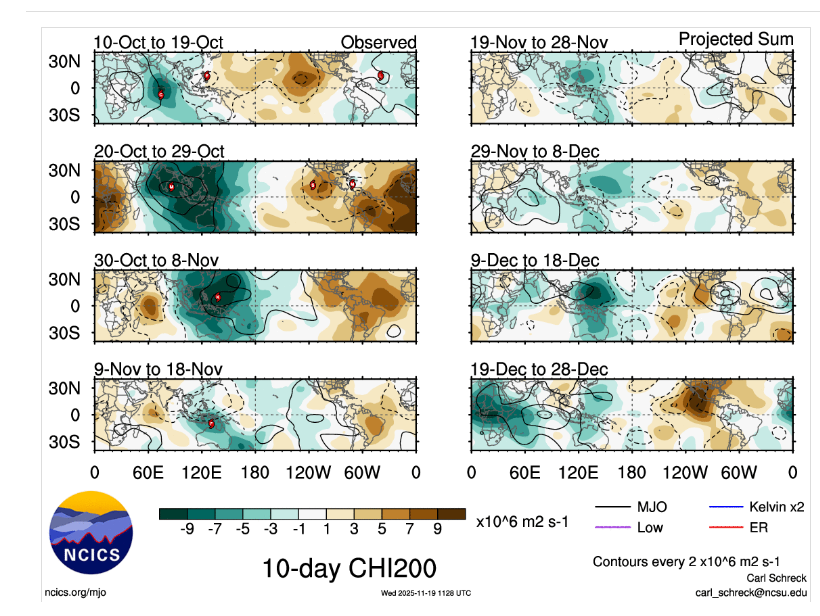
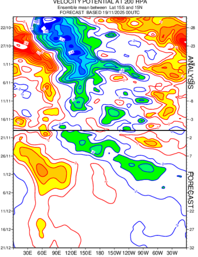
I got cut off for a few min,kinda busy ATM,but by those pics seemingly shows into the 2nd week of Dec into the WP just constructive interference from Rossbly.Kelvin which looks like the MJO is into the Maritime/WP,but its not.Its still in the WH and getting into the IO towards the end of the month of Dec, -

November 2025 general discussions and probable topic derailings ...
MJO812 replied to Typhoon Tip's topic in New England
Judah Cohen says get ready -

Major Hurricane Melissa - 892mb - 185mph Jamaica landfall
Windspeed replied to GaWx's topic in Tropical Headquarters
NSF NCAR researchers have confirmed that the record-breaking wind gust of 219 kts (252 mph) recorded in Melissa was accurate after completing their analysis. https://news.ucar.edu/133047/record-breaking-winds-confirmed-hurricane-melissa -
November 2025 general discussions and probable topic derailings ...
dendrite replied to Typhoon Tip's topic in New England
I’m scared https://www.cnn.com/2025/11/19/weather/polar-vortex-cold-snowy-december-stratosphere -
They are actually making snow right now. And yeah…they will only be opening trails off of two lower lifts for now. I would still think they would start blasting on Conifer in a week or so if temps allow
-
Tons of rain on the radar, but NO RAIN in central Texas. There's one thing we do damn well - We are The Boss, when it comes to Drought down here. No one does Drought like central Texas. La Nina's helpin us out too, deflecting storm tracks safely away from my backyard. I'll forecast this storm. No one does this like yours truly down here, and I have only been here 7 years. Dallas, They will have frantic water rescues by 3am. 3 to 9 inches easily. Most of the rain will pass safely over Austin. We *MIGHT* eke out half an inch. Yeah, that really helps. We are now the fastest growing megalopolis (Dallas/Austin/Buda/Kyle/SanMarcos/San Antonio) in the World. We passed Dubai and the entire UAE last year. WE WILL RUN OUT OF WATER. When THAT happens, water will be far more expensive than gasoline. Every major business is heading for Austin. This place is already a madhouse in rush hour. It's gonna get MUCH, MUCH worse. Everyone in New York City is heading down here, too. We'll add 3 million in the next 12 months! New Yorkers can't stand the snow and the cold, that is why so many people are suddenly moving out of NYC. All that snow is bad for business up there. Austin does not get snow. We don't get rain, either. Not much. Well north usually gets the rain. That would be Dallas, Oklahoma and Missouri, Louisiana. You know what I think? The lack of water in Texas will eventually cause another exodus, this time farther east, to pastures that get much more water, like New Orleans. Nightlife there is stellar, too, and they have casinos. Texas never will. This place is permanently stuck in the 1950s. Except for traffic and water shortages straight out of the 2090s.
- Today
-
December 2025 Short/Medium Range Forecast Thread
jaxjagman replied to John1122's topic in Tennessee Valley
Just to edit the pic above ill post it here,wasnt aware i cut the dates out
-
Forecast has clouds increasing. If that happens won't be a cold night.
-
December 2025 Short/Medium Range Forecast Thread
jaxjagman replied to John1122's topic in Tennessee Valley
Typically Dec in Mid/Tn is the wettest month of the year,its even wetter in West Tn into the Ozarks. Take these maps with a grain of this far out,probably from Rossby,Kelvin Waves,,but at least the Euro is showing something similar,but once again a grain of salt this far out