All Activity
- Past hour
-

Possible Record Breaking Cold + Snow Sunday 1/25 - Tuesday 1/27
ILoveWinter replied to TriPol's topic in New York City Metro
Interesting to see what the EPS mean shows -
Yeah, I was living on Gaskins Road for 1994 ice storm. Treacherous event but short in duration. My car skidded home that night and I could not make it up the hill next day to mar my shift and Ukrop’s Fresh Express. It melted pretty quick. So not like this one is projected. 1999 Super Bowl storm was more damaging and impactful, hope we don’t do that type of event.
-
Watches from the SW to NE instead of from the NW to SE? WOW must be southern stream system instead of northern dry system! lol
-

“Cory’s in LA! Let’s MECS!” Jan. 24-26 Disco
The 4 Seasons replied to TheSnowman's topic in New England
@HIPPYVALLEY Watches coming this pm region wide. 100%. OKX almost put them up this morning but they stopped at the PHI CWA. And based on how much they love the NBM im guessing numbers are going to pretty high. Considered hoisting a Winter Storm Watch regionwide with this update, though after collaboration with neighboring offices, decided to hold off with this package given the onset of the event is still around 72 hours out, and changes to the forecast this far out are likely. That said, confidence has only increased in an impactful winter storm to produce a significant snowfall to the region on Sunday, lingering into at least Sunday night. -

1/23/26-1/25/26 Winter Storm Thread
Holston_River_Rambler replied to AMZ8990's topic in Tennessee Valley
Euro trended colder at 6z but that’s all I’ve really looked at. -

“Cory’s in LA! Let’s MECS!” Jan. 24-26 Disco
40/70 Benchmark replied to TheSnowman's topic in New England
May ask him to loan it to me for First Call if the kids are off the rails tonight. -

Possible Record Breaking Cold + Snow Sunday 1/25 - Tuesday 1/27
SACRUS replied to TriPol's topic in New York City Metro
Total QPF is 1.1 and total snow at 10:1 (with sleet) is 7.7 - NYC -
To me the cold is dumping increasingly in the central conus and much less so in the east. The -AO is legit. That will also give fuel to the primary to hold on longer “bend back” than latest guidance.
-
As much as some won't like this, I agree, GFS right now is on the southern flank.
-

“Cory’s in LA! Let’s MECS!” Jan. 24-26 Disco
cleetussnow replied to TheSnowman's topic in New England
At least we have something to root for this weekend. The Bills are in a lot of trouble, thats for sure. -

Pittsburgh/Western PA WINTER ‘25/‘26
Burghblizz replied to Burghblizz's topic in Upstate New York/Pennsylvania
I’d say the 6Zs more than held serve! -

1/24-1/25 Major Winter Storm - S. IL, IN, MI and OH
A-L-E-K replied to A-L-E-K's topic in Lakes/Ohio Valley
I saw arctic sand at ozzfest in 1998, they sucked -
 For the Euro, are you saying that of the 1.1, 7.7 inches should be snow and the rest would be sleet + freezing rain? Or would the 7.7 include snow + sleet?
 -
“Cory’s in LA! Let’s MECS!” Jan. 24-26 Disco
40/70 Benchmark replied to TheSnowman's topic in New England
Agreed. Cape/islands and south coast, sure. -
“Cory’s in LA! Let’s MECS!” Jan. 24-26 Disco
cleetussnow replied to TheSnowman's topic in New England
I agree. He took a couple dozen weenies right across the forehead for it… I thought it was not out of this world with ratios. -
It’s not done.
-

January 24-26: Miracle or Mirage JV/Banter Thread!
BlizzardNole replied to SnowenOutThere's topic in Mid Atlantic
Highs in the low to mid 80s in south FL the next few days! So different from the typical cold blast in the east where south FL is in the 50s. Anyone that booked a trip to FL this weekend got their money's worth -
Possible Record Breaking Cold + Snow Sunday 1/25 - Tuesday 1/27
SACRUS replied to TriPol's topic in New York City Metro
Conistent now with 1 - 1.25 QPF s -
Yea agree that this willl be juicier in that regard The antecedent airmass is also warming…albeit from a very cold to cold in the east. Need to watch it closely… But the typical areas that can’t rely on just the antecedent airmass to stay all snow need to worry about a lot of mixing already. Cape/islands, coastal RI and CT.
-
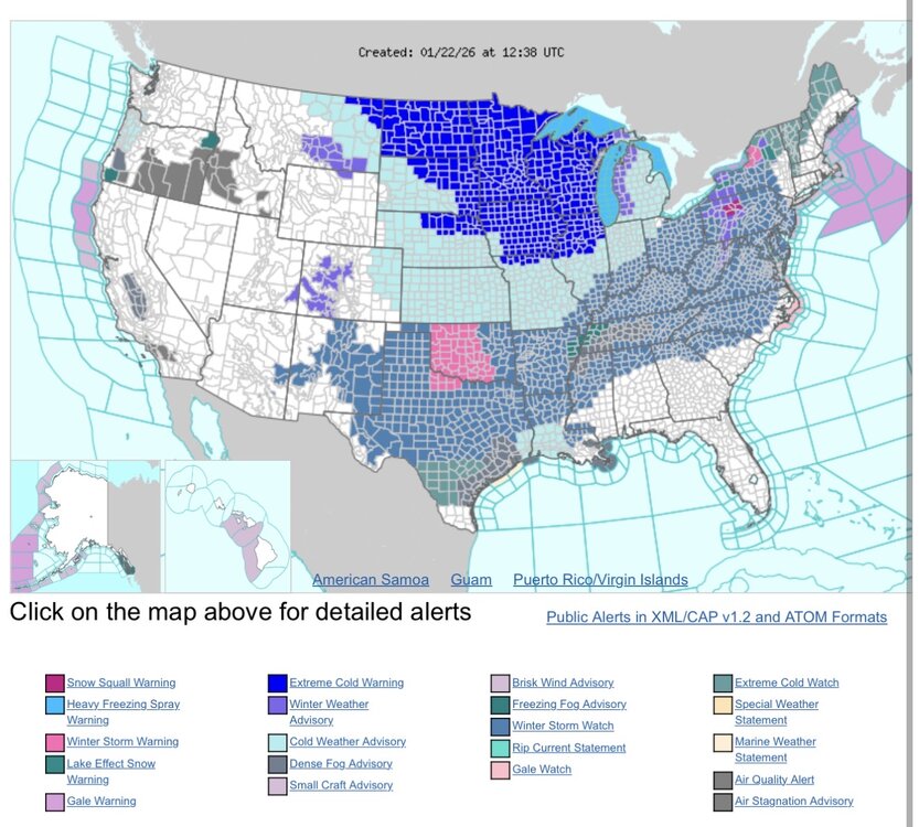
This is a crazy map
-
“Cory’s in LA! Let’s MECS!” Jan. 24-26 Disco
40/70 Benchmark replied to TheSnowman's topic in New England
Yea, just dump the ocean all over me in this airmass. -

Central PA Winter 25/26 Discussion and Obs
Blizzard of 93 replied to MAG5035's topic in Upstate New York/Pennsylvania
This is not right if you include 2 day totals. I know for a fact that Feb 1st 2021 started the evening of Jan 31st and we had a few inches, then the clocked turned midnight & the rest was on Feb 1st. -

January 24-26: Miracle or Mirage JV/Banter Thread!
aldie 22 replied to SnowenOutThere's topic in Mid Atlantic
Yeah that is really playing it conservative...perhaps their in house model the IAN is showing a lot of sleet -
Retreating high is giving the room for north tics on this one.
-
Which models trended cooler at 0z? That will save me from having to dig back through icy maps!