All Activity
- Past hour
-
If I still had photoshop and time to make a detailed map I would. Just wanted to get my thoughts out there.
-
The hard to read text was the first thing I noticed
-

Pittsburgh/Western PA WINTER ‘25/‘26
Rd9108 replied to Burghblizz's topic in Upstate New York/Pennsylvania
Good to see i woke up and the warm tongue isnt licking all the way into northern PA or anything. Ill take a small south adjustment. -
I'm going with 10-14" here, This is still a SWFE unless you get a secondary to develop its has a ceiling.
-

January 25-26 Winter Storm Potential
Hurricane Agnes replied to Ralph Wiggum's topic in Philadelphia Region
7z NBM.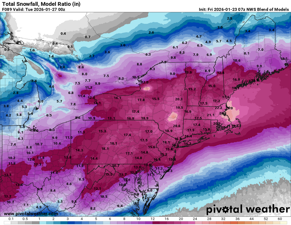
-

Possible Record Breaking Cold + Snow Sunday 1/25 - Tuesday 1/27
weathermedic replied to TriPol's topic in New York City Metro
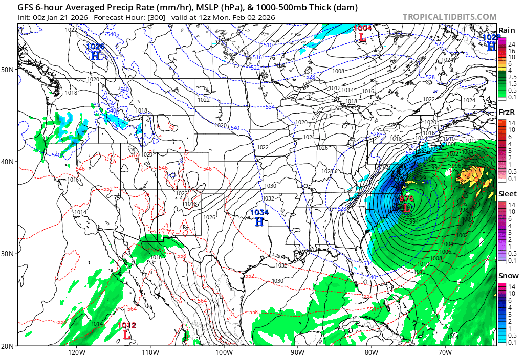
Good AM discussion out of OKX The overall synoptic picture into early next week continues to sharpen. At the surface, arctic high pressure slides east from the Great Lakes into the Northeast this weekend. Meanwhile, low pressure develops and tracks through the South before redeveloping off Cape Hatteras, passing near or just inside the 40N/70W benchmark into Monday. Aiding the potential for snowfall, an arctic air mass settles in ahead of the storm. 925 mb temps look to fall toward -20C or below on Saturday, with surface temperatures progged in the teens during the afternoon, setting up one of the coldest days in several years. This will allow snow to fall everywhere at the onset, which looks to develop rather quickly either very late Saturday night, or more likely Sunday morning around or after daybreak. Periods of heavy snow then appear likely late Sunday morning through the afternoon via the strong frontogenetic and thermal forcing aided by an anticyclonic upper jet to the north. Snowfall rates in this period likely eclipse 1 in/hr at times, perhaps closer to 2 in/hr. Given the cold air mass in place initially, SLRs start out on the higher side (15-18:1) at onset, gradually falling back toward 10:1 or lower along the coast by late afternoon as the mid levels warm. With guidance having adjusted to a closer to the coast surface low, the proximity introduces the possibility of enough warm air intrusion around 800 mb for the snow to mix with or change to sleet Sunday evening. Best chances for this are along the coast, including Long Island and NYC metro. Lower confidence in this occurring going north, with all snow still the most likely solution into the Lower Hudson Valley and Southern Connecticut. Freezing rain or drizzle also cannot be ruled out, though significant icing appears unlikely. As the coastal system deepens and lifts north and east into Monday, the boundary cools once again, and any wintry mix likely tapers as snow showers or flurries into late Monday morning or afternoon. Any additional accumulation is likely light. Forecast snowfall totals have decreased slightly along the coast. This is due to the increased potential for mixing as the warmer air aloft works in. It should be emphasized though the heaviest and steadiest precipitation is expected Sunday morning into early evening, with the bulk of snow accumulation occurring prior to any potential changeover. With QPF progged over an inch, areas that remain all snow should be able to yield double digit snowfall. The question becomes how much warm air is able to work in and force a changeover to sleet, cutting down snow totals. All said, still expecting a widespread 8 to 14 inches across the region, with localized amounts perhaps approaching a foot and a half where best banding sets up and ptype remains all snow. Greatest likelihood for this is across the interior. We remain just over 48 hours from event onset, so opted for no headline changes with this update. It appears likely warnings will be warranted for all areas later today or tonight, dependent on no significant deviations in forecast thought. Continue to monitor the forecast on what is increasingly likely to be a major winter storm with significant disruption to travel and daily life early next week. -

January 24-26: Miracle or Mirage JV/Banter Thread!
anotherman replied to SnowenOutThere's topic in Mid Atlantic
It’s the reason people were freaking out about this three or four days ago. Well, that and social media computer models being shared. -

Central PA Winter 25/26 Discussion and Obs
mahantango#1 replied to MAG5035's topic in Upstate New York/Pennsylvania
-
No title, no legend, hard to read text, etc. I thought you taught these people better @mappy
-

Pittsburgh/Western PA WINTER ‘25/‘26
southpark replied to Burghblizz's topic in Upstate New York/Pennsylvania
My thoughts too. I was happy when I woke up to the new runs (thanks Colonel but go to sleep) ! -
Spotted it Tuesday night and posted in Southeast Forum:

-

January 24-26: Miracle or Mirage JV/Banter Thread!
dailylurker replied to SnowenOutThere's topic in Mid Atlantic
I'm actually planning a Saturday night 7 mile thru hike. I'm thinking about starting at midnight and finishing at daybreak. Want to come? It will be really fun. -

Possible Record Breaking Cold + Snow Sunday 1/25 - Tuesday 1/27
MJO812 replied to TriPol's topic in New York City Metro
What a mess it will be outside if we get 6 plus inches of snow and some sleet. -
.thumb.jpg.6a4895b2a43f87359e4e7d04a6fa0d14.jpg)
Central PA Winter 25/26 Discussion and Obs
Yardstickgozinya replied to MAG5035's topic in Upstate New York/Pennsylvania
Proximity fuse settings ? -

January 24-26: Miracle or Mirage JV/Banter Thread!
WxUSAF replied to SnowenOutThere's topic in Mid Atlantic
Apple weather still saying 20” Sunday. Where the hell is this coming from? Does the entire field a huge disservice cause it’s been saying 20”+ all freaking week and it’s not happening. -
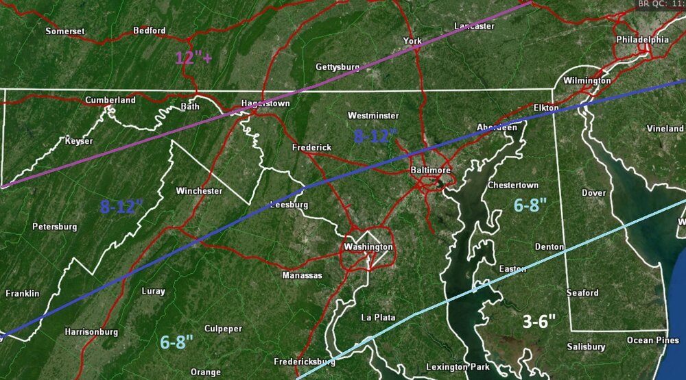
Toss those kuch maps…especially in NNE
-
January 25-26 Winter Storm Potential
Hurricane Agnes replied to Ralph Wiggum's topic in Philadelphia Region
6z AI EC.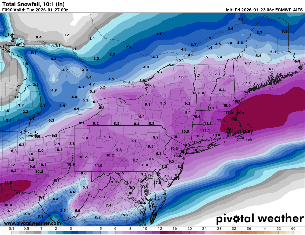
-
I'm stoked for this, but it's a trifle disappointing that even with a fantastic antecedent airmass we still can't seem to escape taint down here. It's been ages since we've had a bona fide major that stayed snow start to finish.
-

January 24-26: Miracle or Mirage JV/Banter Thread!
snowfan replied to SnowenOutThere's topic in Mid Atlantic
Go for a hike out at bacon and enjoy getting pelted by sleet in the eye balls -
Here is what I am going with. Obviously just showing snow predictions.
-

“Cory’s in LA! Let’s MECS!” Jan. 24-26 Disco
bristolri_wx replied to TheSnowman's topic in New England
"not the governing voice" -
Have been thinking and doing some prep since Wednesday, have a small generator that can run some things but not an electric heater. Have a wood fireplace so stocked there. Had an indoor propane heater on order for delivery today, but got notice yesterday, out of stock and order cancelled. Think I might be out of luck trying to find a Mr. Buddy portable propane heater around town.
-

Possible Record Breaking Cold + Snow Sunday 1/25 - Tuesday 1/27
Voyager replied to TriPol's topic in New York City Metro
Yup. Right or wrong, we're getting to the time where I pay more attention to the mesos over the globals. -

“Cory’s in LA! Let’s MECS!” Jan. 24-26 Disco
WxWatcher007 replied to TheSnowman's topic in New England
We take. Excellent trends up our way. -
This is going to be in the 14-15:1 range up here for most of the duration.