All Activity
- Past hour
-

Possible coastal storm centered on Feb 1 2026.
WestBabylonWeather replied to Typhoon Tip's topic in New England
GFS trending better but euro trending worse worries me. -
If the meat of that developing advection lobe continues to trend west along the major axis here, the surface depiction will change in a hurry. Notable improvement at H5 already (in the same direction as the GFS/AIGFS, even if the ECAIFS only nudged a bit initially). Holding it back right now a bit is the trend in the lobe over SE Canada.
-

The “I bring the mojo” Jan 30-Feb 1 potential winter storm
BornAgain13 replied to lilj4425's topic in Southeastern States
I do like that the AI GFS has been trending wetter and wetter. -

The “I bring the mojo” Jan 30-Feb 1 potential winter storm
Tony Sisk replied to lilj4425's topic in Southeastern States
This is looking more and more like a snowstorm for the Sharks -

The “I bring the mojo” Jan 30-Feb 1 potential winter storm
cbmclean replied to lilj4425's topic in Southeastern States
I suspect that IF the storms amps at all, a NW trend is inevitable, because the cold press almost always ends up being overmodeled. Sure, suppressed/OTS is definitely still an option, but as of now I think this is an ideal presentation for Triangle east, with the storm still there but hanging out just off the coast. -

E PA/NJ/DE Winter 2025-26 Obs/Discussion
Lucy Pull replied to LVblizzard's topic in Philadelphia Region
Agree, delicate setup. Would like to see the ULL not dig as far south and trend negative a bit sooner. Climatologically speaking a storm of that magnitude as portrayed by the GFS in the South is extremely unlikely. Although anomalous setups can produce anomalous results. -
AIFS wants a weak Miller B a little past h200 on the 12z. Has showed up a couple times on previous runs and other models but I think this is the strongest signal so far.
-

Possible coastal storm centered on Feb 1 2026.
dryslot replied to Typhoon Tip's topic in New England
Here a bit there a bit everywhere a bit, bit. -
The GFS/GEFS is going to have to have more support. The 12z GEM-para does lend some support. However, the GFS is on the far west side of guidance. I still kind of think we are depending on the northern stream energy for snow, and not coastal backing. That type of cold should bring snow showers with it. The GFS isn't an outlier at this point, but it's close. Other models are taking baby steps towards it, BUT...the window is rapidly narrowing for this to trend westward. Our best path forward is for the northern stream system to be stronger.
-

E PA/NJ/DE Winter 2025-26 Obs/Discussion
Birds~69 replied to LVblizzard's topic in Philadelphia Region
Patch knows I'm a weenie. Sends me stuff all the time like a little kid and candy. NWS realizing there's some potential...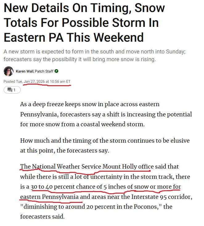
-
Brought in my rain gauge to thaw out from the system this past weekend. Just over .7 on liquid. Have nothing to compare it with locally though.
-
Thought it’d be today, but…
-

Possible coastal storm centered on Feb 1 2026.
DavisStraight replied to Typhoon Tip's topic in New England
A wee here and a wee there and it hits us. -
Euro doesnt have temps above freezing throughout the whole run which goes to February 11.
-
It’s always like this though. It’s never just 100% of models show no snow. Always 1 that does just to make you lose more hours of your life following it for the final heart break at T minus 0 hours
-
I really wish the GFS would be right for once. It is trying to pop a low in the panhandle of Florida. There’s a ton of potential with what it is showing.
-

The “I bring the mojo” Jan 30-Feb 1 potential winter storm
DTP replied to lilj4425's topic in Southeastern States
Np- hope it helps- just hate to see everyone get so darn disappointed....the Schrodinger's cat paradox comes to mind- except with modeled storms- is it alive, or is it dead? Can't be both at once -
Boston had 0” on 90% of model runs this time last week.
-

Possible coastal storm centered on Feb 1 2026.
Kitz Craver replied to Typhoon Tip's topic in New England
Meaning nada? -
Euro doesnt have temps above freezing throughout the whole run which goes to February 11.
-
When you have the cold in place there are so many more ways to score. Get some precip up this way in the next couple weeks and it will be frozen.
-

Richmond Metro/Hampton Roads Area Discussion
overcautionisbad replied to RIC Airport's topic in Mid Atlantic
Guess it will be important to watch the 18z and 0z -
When it comes to this coastal low, the question facing us is this: Tuck? Or no tuck?
-
Looks like the 12z Euro AI ticked east a hair, not sure it matters against what is an over whelmingly jump west on most models at 12z.
-

Possible coastal storm centered on Feb 1 2026.
tomcatct replied to Typhoon Tip's topic in New England
Some years it wants to snow..some winters it finds any way possible to screw us and not snow..if this snowy winter continues, it'll find a way. Either way, give it 24 hrs and let's see where we're at.


.thumb.jpg.9707d4addca3d84715ae3d888c5c10d6.jpg)