All Activity
- Past hour
-
It was a crazy event. First time in my life we hit the basement lol. I told my wife it honk there’s a tornado outside
-

Spring 2025 Medium/Long Range Discussion
WestMichigan replied to Chicago Storm's topic in Lakes/Ohio Valley
Not liking the looks of this heading into summer.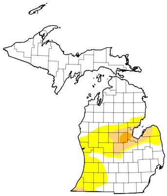
-
Currently 59 degrees Picked up .28” yesterday and today so far .03” of rain. Appears the northern tier was and underachiever compared to most of you guys.
-
Gut say no, but we'll see. My largest grip this spring with all the rain is that my lawn SUCKS. Overseeding next spring after chasing away the damn grubs
-
Absolutely love it! Late spring of yore, reminds me of 30 years ago
-
0.59 in the bucket Wed - overnight into this morning here New Brnswck: 0.61 LGA: 0.52 EWR: 0.51 NYC: 0.50 JFK: 0.27
-
Yeah we have the same problem here in Baltimore county. They refuse to let us bring a tractor/4 wheeler on the fields to drag them. They have to line and set out the bases. We have a group of parents that will rake the entire diamond to get it playable. Oh and we are only allowed to use 2 bags of quick dry per field... any more than that, and the field is unplayable. It is just plain stupid. The tournament we were at in Elkridge this weekend... I was made aware that Howard county has the same issue as we do.
-
Records: Highs: EWR: 97 (1987) NYC: 97 (1969) LGA: 95 (1987) JFK: 99 (1969) Lows: EWR: 40 (1936) NYC: 43 (1902) LGA: 48 (2021) JFK: 46 (1949) Historical: 1877: A "terrific" two-day long sandstorm sandblasted Yuma AZ. (28th-29th) (Ref. The Weather Channel) 1947: An unprecedented late-spring snowstorm blasts portions of the Midwest from eastern Wyoming to eastern Upper Michigan. The heavy snow caused severe damage to power and telephone lines and the already-leafed-out vegetation. 1951 - A massive hailstorm, from Wallace to Kearney County in Kansas, caused six million dollars damage to crops. (David Ludlum) 1953 - A tornado, 600 yards wide at times, killed two persons on its 20 mile path from southwest of Fort Rice ND into Emmons County. Nearly every building in Fort Rice was damaged. The Catholic church was leveled, with some pews jammed four feet into the ground. (The Weather Channel) 1982: Two significant tornadoes ripped through southern Illinois. The most severe was an F4 that touched down northeast of Carbondale, Illinois then moved to Marion. The twister had multiple vortices within the main funnel. Extensive damage occurred at the Marion Airport. A total of 10 people were killed, and 181 were injured. 648 homes and 200 cars were damaged or destroyed, with total damages around $100 million. 1986: Hailstones over 3 inches in diameter pounded South Shore in Montreal, Quebec Canada causing over $65 million in damage. 1987 - Thunderstorms in West Texas produced softball size hail at Lamesa, and hail up to twelve inches deep east of Dimmitt. Thunderstorms also spawned seven tornadoes in West Texas, including one which injured three persons at Wolfforth. Thunderstorms deluged the Texas Hill Country with up to eleven inches of rain. Severe flooding along the Medino, Hondo, Seco, Sabinal and Frio rivers caused more than fifty million dollars damage. (Storm Data) (The National Weather Summary) 1988 - A powerful cold front brought snow and high winds to parts of the western U.S. Austin, NV, was blanketed with ten inches of snow, and winds gusted to 75 mph at the Mojave Airport in California. Strong southerly winds and unseasonably warm weather prevailed in the north central U.S. Glasgow, MT, equalled their record for the month of May with a high of 102 degrees. (Storm Data) (The National Weather Summary) 1989 - Wintry weather gripped parts of the northwestern U.S. for the second day in a row. Great Falls, MT, was blanketed with 12 inches of snow, which pushed their total for the winter season to a record 117.4 inches. Six inches of snow whitened the Cascade Mountains of Oregon. (The National Weather Summary) (Storm Data) 1990 - Afternoon and evening thunderstorms produced severe weather from north central Colorado to the northern half of Texas. Severe thunderstorms spawned four tornadoes, and there were seventy reports of large hail or damaging winds. Midday thunderstorms produced wind gusts to 90 mph at Hobart, OK, and produced up to three and a half inches of rain in eastern Colorado in four hours. (The National Weather Summary) (Storm Data) 2002: Parts of western New York State had up to 5,000 homes were without power at the peak of the storm from downing trees and power lines. Hail up to 1 inch in diameter was reported in Perry, Wyoming County. The training thunderstorms dropped 4 to 6 inches of rain in two to three hours in a localized area from Phelps to Newark. A State of Emergency was declared that was declared in Newark remained in effect for a week with most schools and businesses closed during that time. Nearly 300 basements were flooded and several roads covered with up to a foot of water remained closed for several days. (Ref. Wilson Wx. History)
-
Teleconnections support a more significant heat ~ D6 ... 12 at some range in there. The operational run blend is dodging that signal with a flattened, fast progressivity to the overall handling. It's not clear if this operational aspect is a bias, or a real a signal... Those two indicators are somewhat in conflict at this time. Just sayn' I wouldn't be very assured in a cooler look between D6 and 12... June 4-8th in particular is when a shallow -EPO teams up with a very strong -PNA, while the NAO is neutral positive, and while all this is happening, the operational heights just refuse to build the ridge through the teleconnector region - There were several run cycles up through about 2.5 days ago that were substantially warmer - actually better fits... The telecon part of this puzzle has not deviated since prior to then, thru it, and up until now, either. The operational runs have been oscillating more than less - right now, they are less. Sometimes when the operational blends disagree with the multi- ensemble source derivatives ( the -PNA ...+EPO... -AO...blah blah), they win. Other times, they lose ... This is probably like in the winter, when there is a loud signal for a large event in the extended, then we 'black out' for 3 days and never hear from it ... only to have it come storming back at 84 hours or whatever. We'll have to keep an eye on it as inCREdible temperature nerds with nothing better to to do than to monitor whether we make 88s out of 77s or not. hahaha. F, it's better than this recreating whining and complaining bs at least.
-
60 / 57 cloudy and maybe some pokes of sun through the day which should be mainly dry outside som mist/drizzle. Upper 60s - low 70s. Clouds / heavier rain Friday pm into the night and warmer more southerly flow mid 70s. Saturday scattered storms and rain throughout the day. Finally clearing pout Sunday - we'll see how sunny it can get and staying near or below 70. Step up warmup next week to normal and above by the 5th - onshore flow should keep any heat / 90s inland into the warmer spots with ULL off shore undercutting the ridge and keeping the coastal areas in an easterly component. Overall, warmer into the 9th and beyond. Heat building into the plains and Midwest should come east in dribs and drabs until the ED ride establishes by mid month. 5/29 - 5/31 : Wet 1- 1.5 inches additional 6/1 - 6/4 : Nearer normal overall and dry 6/5 - 6/8 : Above normal - warmer-hot inland with onshore tendency along the coast 6/9 - beyond : Overall warmer - heat limited to inland/ North and west of the coast
-
You can see the micro burst in the rear velocity in the tweet rjay posted. A ef0 tornado would have produced notable damage, like trees twisted at the tops and falling in different directions. Since I saw the damage in Babylon that evening in my gfs old neighborhood I can verify it was straight line winds. All trees were facing the same direction and mainly uprooted and not sheared. Can’t wait for our severe season July/August. This never ending late march early April pattern has got to go.
-
81/40 here, first venture into the 80s this season. Sun was hot but dews remained modest.
-
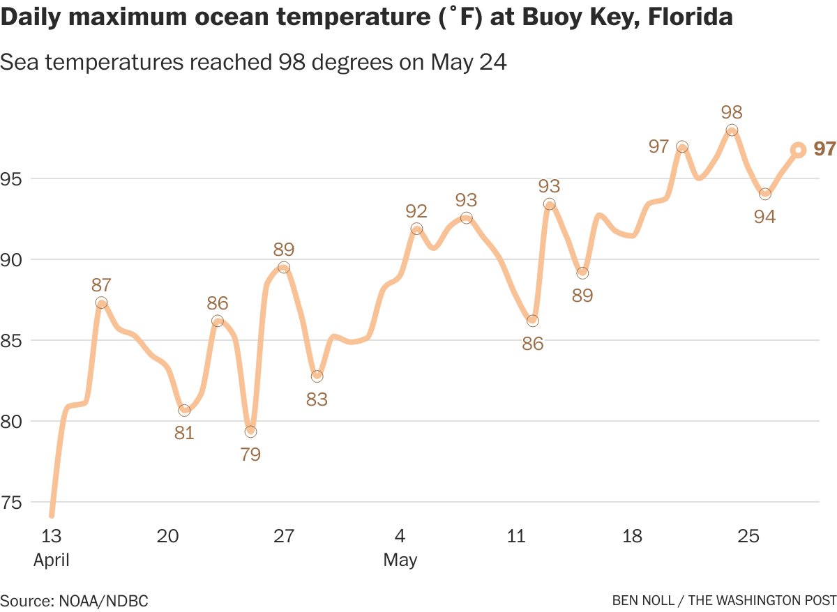
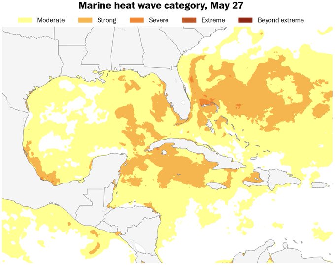
Marine heat waves forming in the Gulf, near Florida and the Bahamas. May have have an effect on our sensible weather in the months ahead, and already impacting Houston, TX. and Fla.

-
-
Not sure if it's as accurate as Jerry's squirrels but the animals are shedding their coats pretty quick.
-
I’m on the EYO board and we’ve had this discussion/argument with Rec and Parks for ages. I think we’re finally close to getting approval to let coaches work on fields to get them playable. They’ve refused up until now and they don’t work particularly hard to get them playable.
- Today
-
Yes chilly so far.
-
We'll see. I expect a AN and humid summer. That's just our new climo. But high end stuff? Yeah not sure.
-

Central PA Spring 2025
Mount Joy Snowman replied to canderson's topic in Upstate New York/Pennsylvania
Low of 53 with 1.54” of additional rain, for an event total of 1.77”. Drought be gone. Should sneak in a nice day today. -
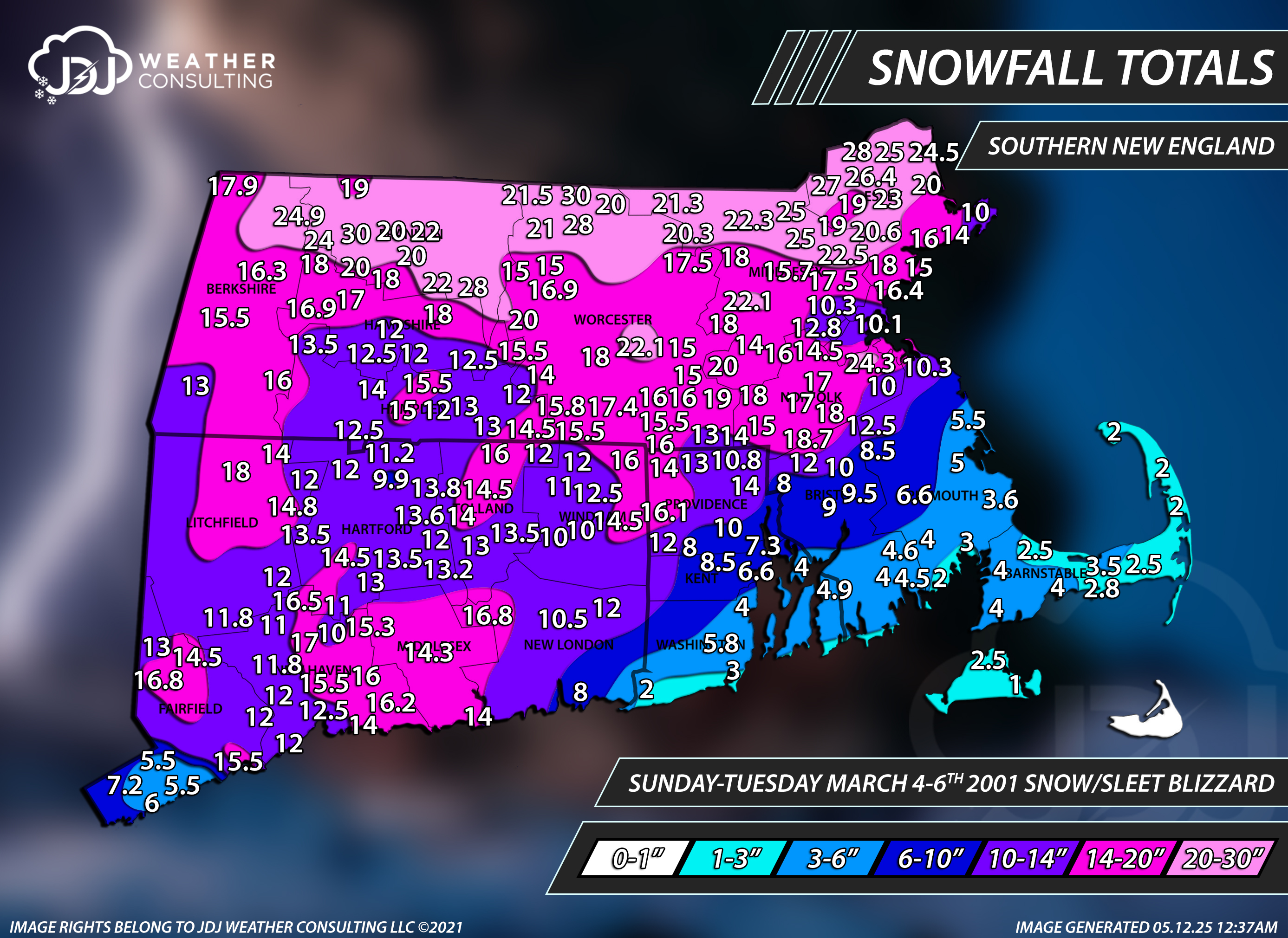
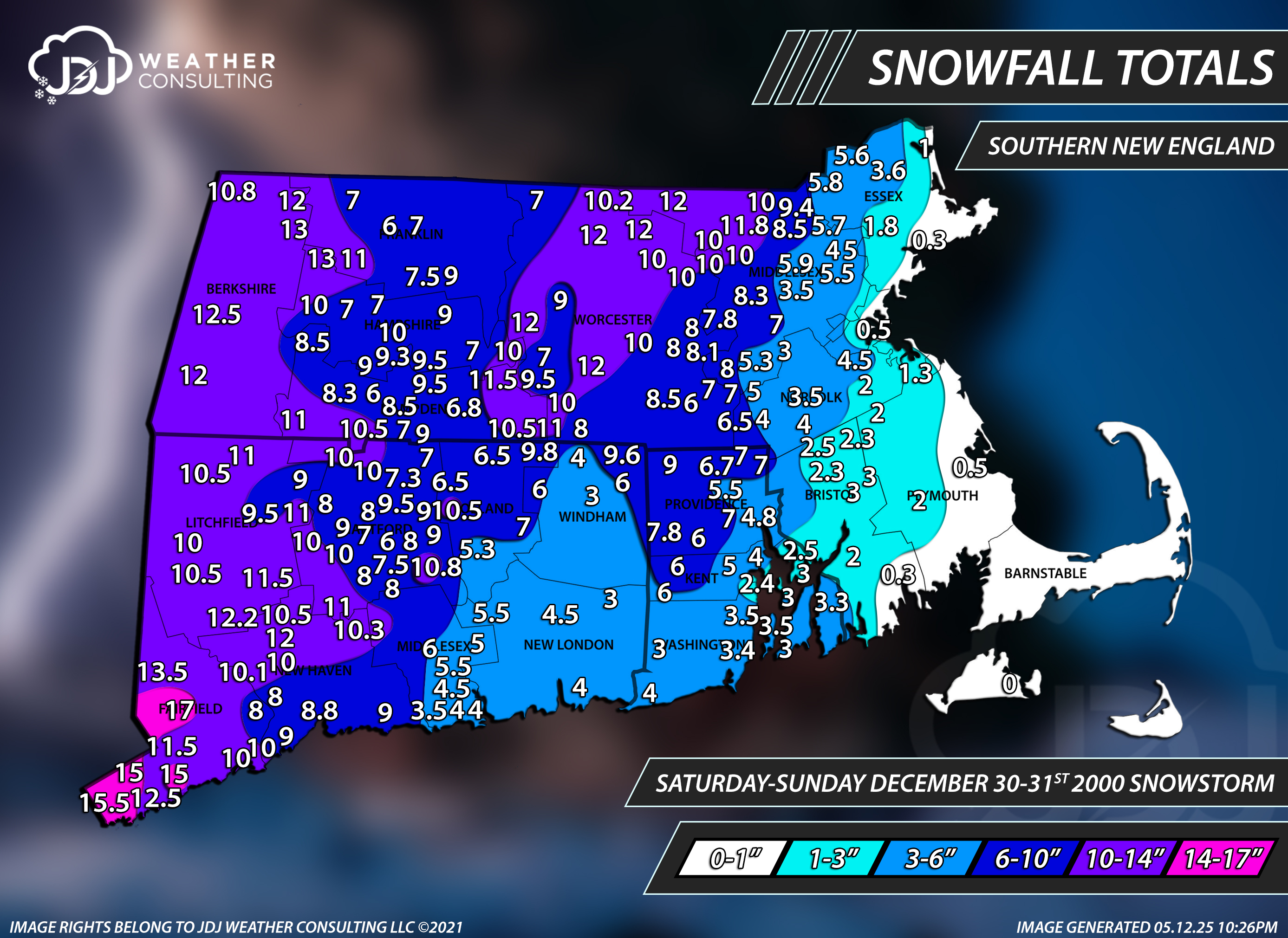
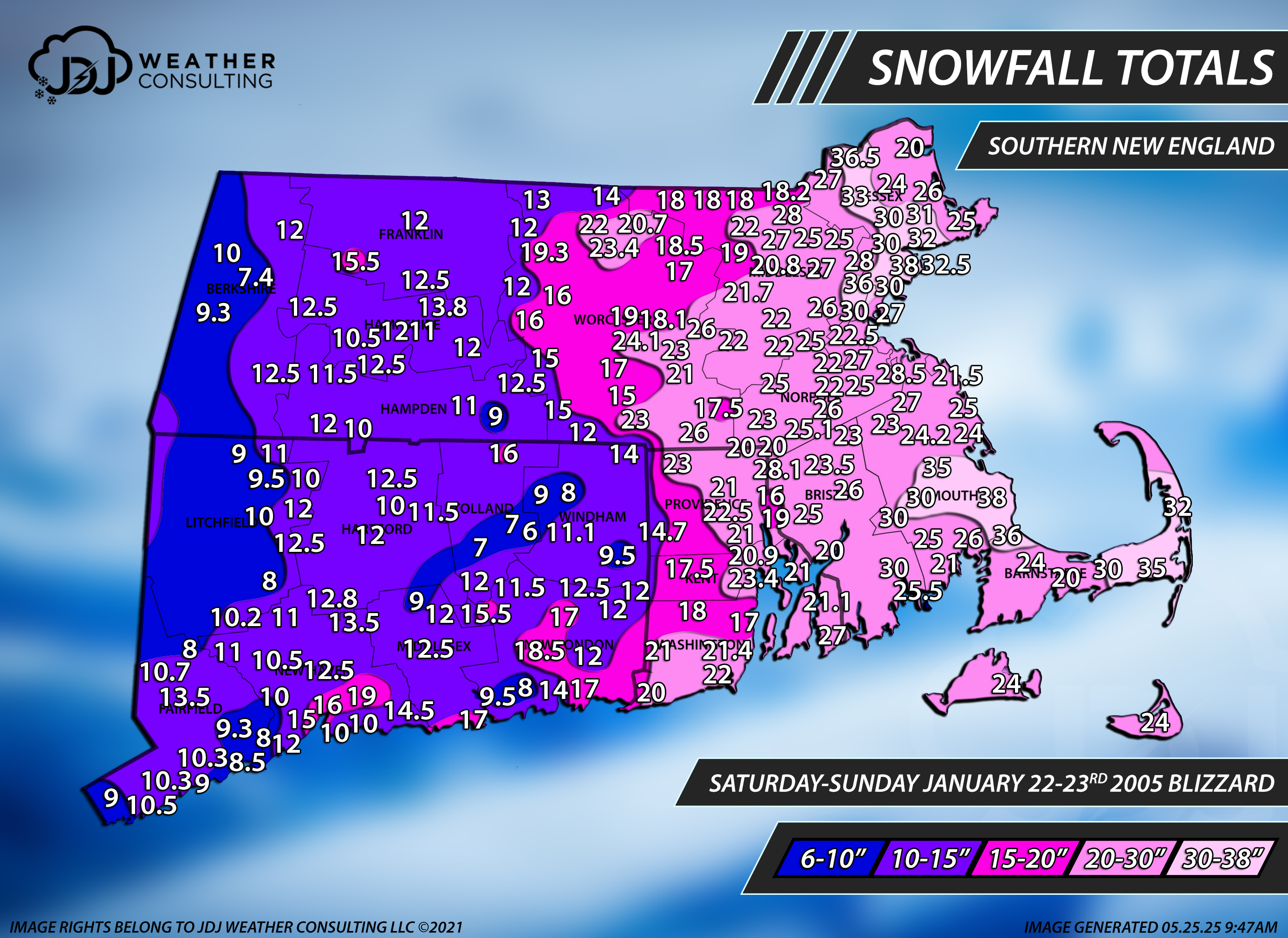
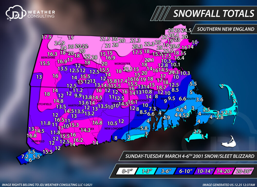
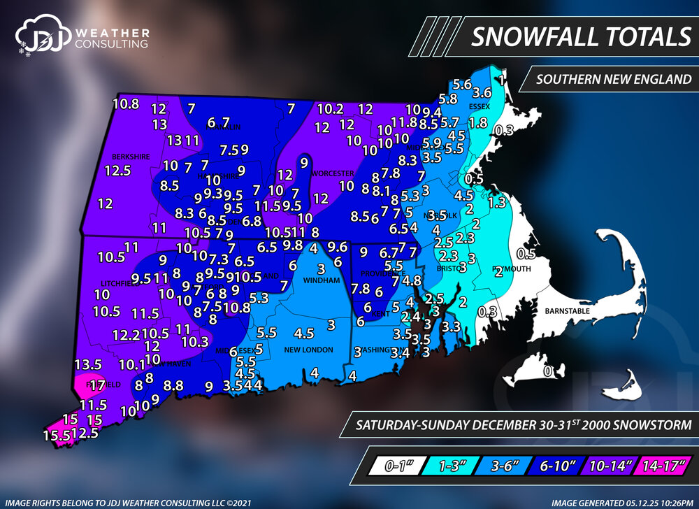
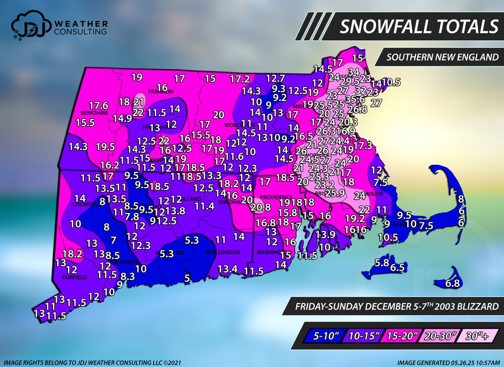
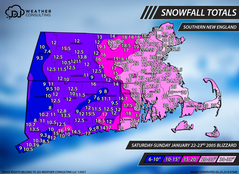
Hey @H2Otown_WX i just added a full radar loop of your favorite storm Dec 30th 2000 and Feb 5th, Mar 4-6th 2001 as well as Dec 2003 and Jan 2005. Even the blizzard of 96 is now up. All new snowfall maps as well. I cant link them here cuz the file sizes are massive.
-
Ya the worst HHH summer doesn't look to happen this year. It will be warm but not HHH all the time like some are thinking
-
I am with you... This weekend is the final games of league play and conference tournament starts next weekend. Very little time to get in any makeup games. Our team is lucky that we do not have any makeup games... Some teams still have 3 or 4 makeup games and are already supposed to play 4 games this weekend.
-
It's not a hot pattern going forward and I wouldn't say all that humid. Probably a lot of 78-85 with some days of dews in 60s. Solid early June weather. June hasn't been that hot lately over last several years.
-
Final total is 2.38 inches
-
I had no power for days. I am convinced we had a EF0 lol. it was very bad. My entire neighborhood had trees down. I’ll find the pics