All Activity
- Past hour
-
41° and blowing pretty hard. I probably shouldn’t have taken any of the panels off the run yet…the chickens are getting buffeted.
-

Central PA Spring 2026 Discussion/Obs Thread
pawatch replied to Voyager's topic in Upstate New York/Pennsylvania
47 degrees this morning. Picked up .28” of rain last evening. -

Forecasting now vs. 30 years ago
Newman replied to EWR757's topic in Weather Forecasting and Discussion
Well the NWS has implemented new policy/guidance that has completely stripped the human input in forecasting for days 4-7. And even days 1-3 are heavily produced based on the NBM. Take a look at the NWS Billings AFD from 3 days ago and the note at the bottom: https://mesonet.agron.iastate.edu/wx/afos/p.php?pil=AFDBYZ&e=202604081847 So certainly the SOPs for forecasting in the NWS have completely changed. Now we're basically hitting the "send" button on whatever the NBM comes up with. And I can't emphasize enough how BAD the NBM was this past winter in many of our snowstorms. It is inherently a poor model to forecast with when you have short term model disagreement OR when you are dealing with a 90th percentile or 10th percentile type storm. The NWS Mount Holly office was still forecasting 18-24 inches of snow the starting day of the late February snowstorm out in its western CWA. And sure enough nobody saw more than 4-5" of snow. Why did this happen? Because they relied on the NBM which lags in data and model cycles AND weights certain models. Forecasting accuracy will plummet in the NWS until they figure out how to better implement the NBM and/or develop it. -
Wolfie has a derangement syndrome that every warm post is about CC. Sad to see.
-
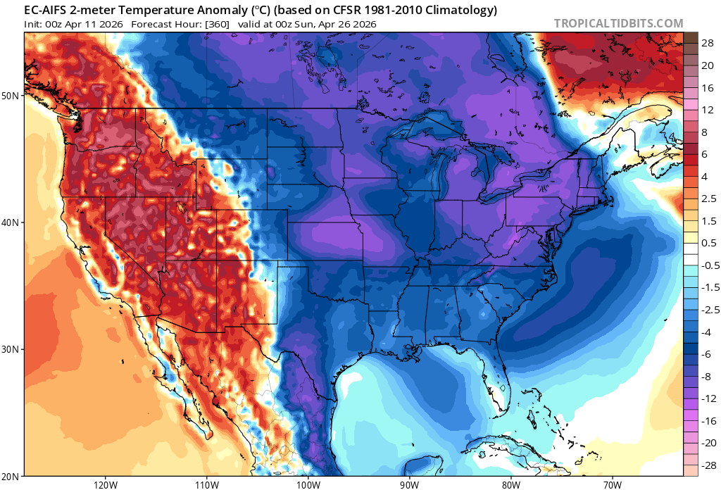
Shift that depiction 500 miles southwest
-
No. MJO 8 and 1 are warm phases in New England in April. The warm anoms in Maine and Southeast Canada will continue to shift south on guidance as it catches on. The cold anoms over the central US SE and Mid Atlantic.
-
How did that month rank overall Because you have to look at the whole and not just a few record days. 2010 was much warmer overall
-
We wish we were in Guam!! Massive typhoon headed that way.. the GFS gets down to 922mb
-
We should get cooler weather once the MJO travels through 8 and 1 along with the NAO and AO dipping negative.
- Today
-
We can hope

-

Chester County PA - Analytical Battle of Actual vs. Altered Climate Data
chubbs replied to ChescoWx's topic in Climate Change
I don't know which stations were used. However the number is more than adequate. There is a dense network of stations in this area. Below is a comparison of raw data to NOAA. The raw data is the same chart that was posted above; but, with Avondale, 10 DEOS stations and E Nantmeal added. As described above, I've taken out the important post -war station moves: Coatesville (46+48), Phoenixville (48), and West Chester (70). I've also removed the temperature difference between stations by taking an anomaly. The anomaly period has been shifted to 2012-24 since all stations except West Chester pre-1970 operated in this period. Anomalies for West Chester are obtained using the 2.1F difference between 2012-24 and 1949-69 from the Phoenixville and Coatesville records. Removing the large post-war station moves and the differences between stations is sufficient to bring the raw data and NOAA into very good alignment for the long-term climate trend.. Not surprisingly, there are short-term differences between between the raw data and NOAA, mainly Phoenixville and Coatesville, between 1960 and 1990, when these stations had periodic adjustments. This shows that for the big picture long-term trend, most of the NOAA adjustments don't move the needle. Only the big moves, with roughly 2F cooling, obscure the warming. NOAA's goal is to remove station changes from the raw data leaving only weather and climate. This comparison shows that NOAA has met their objective in Chester County. If you aren't matching NOAA, you aren't getting the county climate right.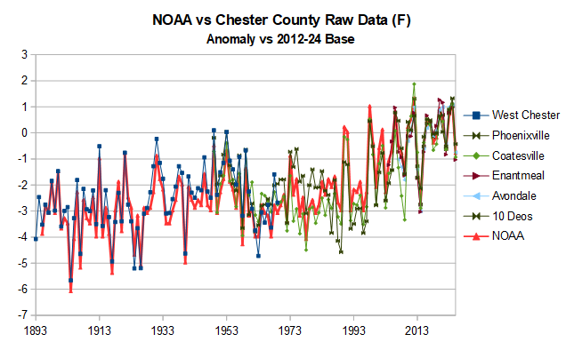
-
seems about right. That will help me.... i was close just have to move the 3" line down a bit
-
Many thanks to all who contributed to this thread - wow you guys sure know a lot about the big ski resorts! Those places make Mammoth look like an Allegheny foothill.
-
Gentlemen, this is the Mammoth Mountain Resort. I know its April but these guys are starting to get hosed down but good by snow and may get 2-3 feet by Monday morning. It's really coming down right now! https://www.mammothmountain.com/on-the-mountain/mammoth-webcam/woolly-cam
-
-33.53
-
Thank you very much!
-

2026-2027 El Nino
snowman19 replied to Stormchaserchuck1's topic in Weather Forecasting and Discussion
Huge SOI crash continuing, strongly negative. -30’s for the last 3 days. 30 day average is negative and continuing to fall -
Maybe we'll get a big snow into our area this upcoming winter,Nino does fairly well with Moderate to strong Ninos,they always produce,but the winter in whole should be AN temps,typically Dec should be fairly warm.
-

E PA/NJ/DE Spring 2026 Obs/Discussion
Albedoman replied to PhiEaglesfan712's topic in Philadelphia Region
Here you go guys- I am the Township Manager of Lowhill Township. You will find this pretty neat. The smoke could probaly be seen all the way To Red Skys house https://www.youtube.com/watch?v=QA7GFlTinxw -

2026-2027 El Nino
TheClimateChanger replied to Stormchaserchuck1's topic in Weather Forecasting and Discussion
Best spring in the history of America. -
2026-2027 El Nino
TheClimateChanger replied to Stormchaserchuck1's topic in Weather Forecasting and Discussion
Hmm, maybe because the old measurements are biased low? Snowfall measurement: a flaky history | NCAR & UCAR News -
I had 32 and 34 the last 2 nights respectively
-
6 of their top ten winters have been after the turn of the century….4 of their top 5 have been after the turn of the century. Interesting for Marquette.
-
Less than three weeks away from true SEVERE SEASON
-
Months and months!