All Activity
- Past hour
-
out of range but the extended HRRR is way south
-
Feeling like spring out there, feels really good, feels rejuvenating. I'll still root for snow when there's something to track but I'm just about done with winter at this point.
-
Yes. But it’s prob not a very large area that would see icing. At least not how it looks now.
-
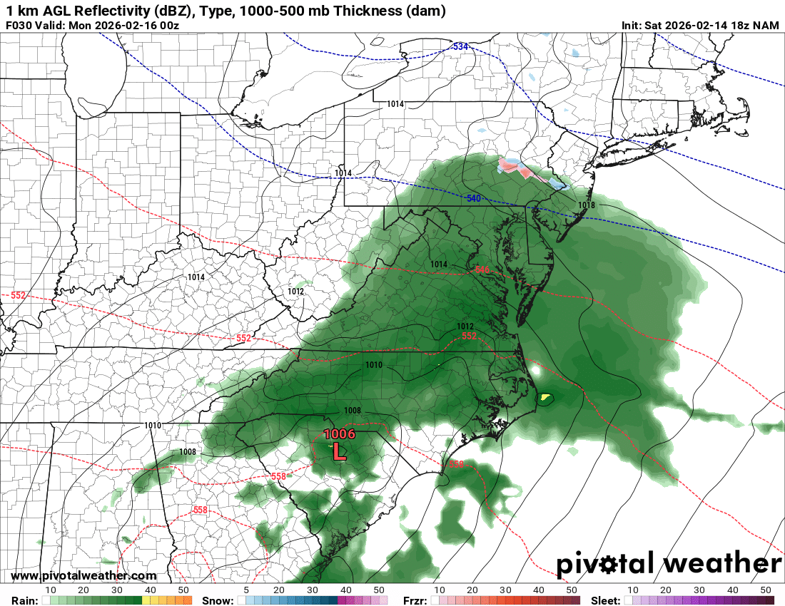
18z NAM says enjoy your front end thump of rain, for the entire MA forum. Temps torched; freezing line way up in northern nj/nyc area.
-

Central PA Winter 25/26 Discussion and Obs
canderson replied to MAG5035's topic in Upstate New York/Pennsylvania
CTP now has Harrisburg with snow accumulation Sunday evening - less than .5” current forecast. -

Pittsburgh/Western PA WINTER ‘25/‘26
colonel717 replied to Burghblizz's topic in Upstate New York/Pennsylvania
Beautiful day to sit on the full sun patio with the fire pit and my Valentine. Almost ready to say I'm done with snow. Models had a tease yesterday but seemed to have backed off. -
I'm impressed with how my snowpack is holding on here. But it's nice to have some days with real solar panel production. Gotta make up for some steep january usage on the ole heat pump
-
We are at the point in the season where I'm more interested in severe than snow. Of course I'm in Chattanooga. If I was up I-81 I'd have a better attitude. Great thing about next week is that little lead trough through the Great Lakes. Our southern trough is not the first; so, moisture return will already be in progress.
-
We like that euro run up here but it’s tenuous
-
 Except you didn’t provide the relevant data. How warm it was the day before doesn’t matter. How warm was it while it snowed? Did the temp drop to 27? If so 2f wouldn’t have mattered and that’s still a snowstorm now. But if it was 32 during the snow, I got bad news for you regarding what math says the +2f would mean
 -

Is we back? February discussion thread
Damage In Tolland replied to mahk_webstah's topic in New England
Isn’t there some icing potential? -

Is we back? February discussion thread
WeatherGeek2025 replied to mahk_webstah's topic in New England
i'd go with Euro AI over euro! Euro just doesn't do good anymore everyone knows this if you're a weather weenie! -

February 2026 Medium/ Long Range Discussion: 150K Salary Needed to Post
bncho replied to Weather Will's topic in Mid Atlantic
Extremely well said! -
 On Oct. 9, 1979 in Staunton it was 70 degrees. From 2 am that night until noon on the 10th, it snowed 9 inches.
 -

February 2026 OBS & Discussion
sussexcountyobs replied to Stormlover74's topic in New York City Metro
I'm in Vernon. It's up to 41.4. This is the first real day of some melting with sun out. -
Down to about 75% coverage, Lower part of the driveway is a swamp. It may have been dry af the last 19 days, but there is over an inch of water in this stuff so as it melts it's putting a dent in the dryness/drought. 48 here
-
Not globally but the rate of increase does continue to accelerate. What’s happened that caused the sudden post 2016 decline in snowfall was a pattern change to a hostile pacific much of the time which has made the 2f matter more because we’re stuck in a warm regime most of the time where even when we do get snow threats we need Them to work with marginal temps and those marginal temps are now warmer. Some of this will get better when a better long term cycle emerges. But make no mistake we’re bleeding snow even in those. For example the last time we timed up a favorable Atlantic and pacific in the 2000s Baltimore only averaged 21” during that period. Better yea but only slightly above what the 30 year mean was anyways. At the same time NYC and Boston were averaging 150-175% of normal! That should have been us! And in the 1960s when a similar pattern happened it was us. But it’s warming so the core of the snowfall shifted north. And we got scraps on the southern edge of the max snowfall anomalies despite a perfect pattern cycle. That’s going to keep happening and get worse. we will continue to see short term cycles of less and more snow but over top of that is the long term decline. Each up will be less up and each down will be more down and eventually Baltimore will have a winter climate similar to what Raleigh used to have where snowfall is an extreme anomaly and not something you expect in any given winter.
-

Presidents' day Snow potential
weathermedic replied to WeatherGeek2025's topic in New York City Metro
Hazardous Weather Outlook National Weather Service New York NY 106 PM EST Sat Feb 14 2026 CTZ009>012-NJZ002-004-006-103>108-NYZ071>075-078>081-176>179-151800- Southern Fairfield-Southern New Haven-Southern Middlesex- Southern New London-Western Passaic-Eastern Passaic-Hudson- Western Bergen-Eastern Bergen-Western Essex-Eastern Essex- Western Union-Eastern Union-Southern Westchester- New York (Manhattan)-Bronx-Richmond (Staten Island)-Kings (Brooklyn)- Northwest Suffolk-Northeast Suffolk-Southwest Suffolk- Southeast Suffolk-Northern Queens-Northern Nassau-Southern Queens- Southern Nassau- 106 PM EST Sat Feb 14 2026 This Hazardous Weather Outlook is for southern Connecticut, northeast New Jersey and southeast New York. .DAY ONE...This afternoon and tonight. Hazardous weather is not expected at this time. .DAYS TWO THROUGH SEVEN...Sunday through Friday. A low pressure system is expected to track a bit further north and will bring some minor snowfall accumulation to mainly southern portions of the region, likely impacting the Monday morning commute to some degree. However, if the trend further north continues then snowfall amounts could be more significant. -
Forecast here actually has snow in it- less than a half Sunday night and the same for Monday. Translation- there might be a period of snow TV.
-
 Damn so in following that logic, it's okay to drive while drunk because my blood is only composed of 0.09% alcohol?
 -
 As a fellow 90s kid I remember some of those fails, lol But I do remember more moderate snows of 6-8" as opposed to what we get now...
 -
46 here and no wind. Beautiful mid February day. It’s coming (spring)
-

Presidents' day Snow potential
Freezing Drizzle replied to WeatherGeek2025's topic in New York City Metro
Mt. Holly also predicts "freezing fog" tonight at least for northern Middlesex County, NJ, with a low of 23 F. I haven't seen that term in a NWS forecast in a while for this area. -
Gorgeous out at the jersey shore. Asbury park was jumping.
-
 Trust me, we used to fail. I had a few disappointing winters in the 90s as a kid (and some great ones), and I lived further north. Now we are more likely to fail!