All Activity
- Past hour
-
On the 12z GFS, we are closer to the cold side of the strong thermal boundary modeled to set up in early December. I expect this boundary to nose southward and affect the north country, but it could potentially push even further south. I'd rather see weaker waves eject northeastward and slowly decay instead of consolidated ULLs pumping the east coast ridge. We could really use some well-timed suppression. The subtle upper level interactions will have huge implications on surface weather over this holiday period and beyond.
-
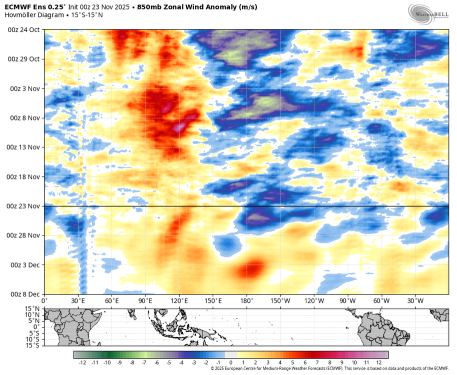
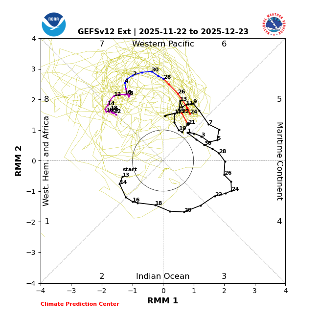
This is clearly phase 8
-

November 2025 general discussions and probable topic derailings ...
klw replied to Typhoon Tip's topic in New England
light but steady snow has started here. -

Fall 2025 Medium/Long Range Discussion
sbnwx85 replied to Chicago Storm's topic in Lakes/Ohio Valley
12z GFS continues the trend. A long way to go but it’s a great hit for Iowa and the northern half of Illinois. Starts to lose steam into Michiana but I would take it.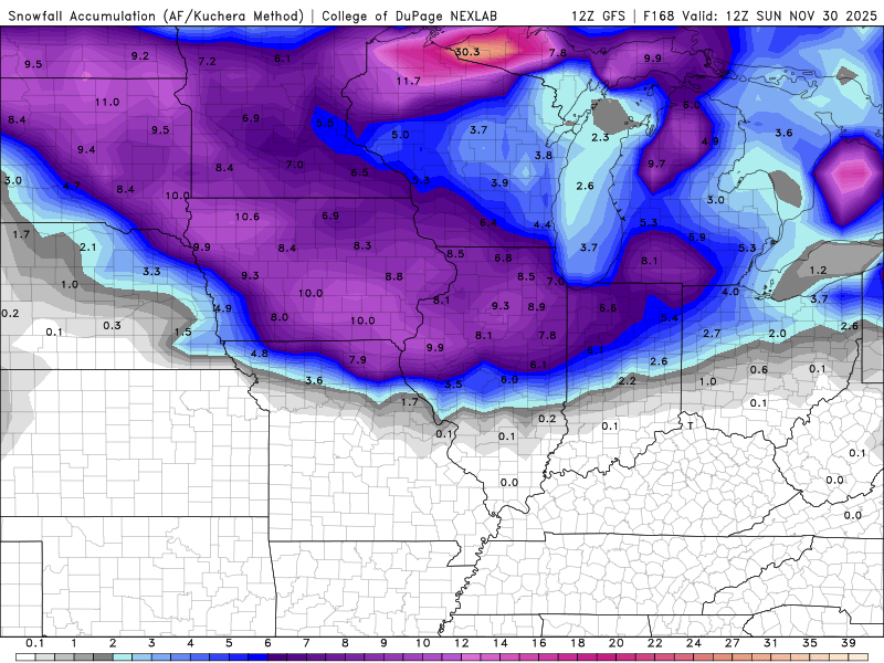
-
DJF MJO last 15 winters (2010-1 through 2024-5): # of days each phase *7: 286 days from 58 phase 7s or 4.9 days/phase *8: 95 days from 34 phase 8s or 2.8 days/phase 1: 76 days from 24 phase 1s or 3.2 days/phase 2: 96 days from 23 phase 2s or 4.2 days/phase 3: 167 days 4: 173 days 5: 212 days 6: 249 days ——————— Per the above data, the # of phase 8 days for the last 15 winters, combined, has been only 1/3 the # of phase 7 days. This was due to a combo of much fewer 8s than 7s (34 vs 58) and much shorter avg. duration for 8 vs 7 (~3 days vs ~5 days). So, there sometimes is a struggle in going from phase 7 to 8. The # of combined 8-1-2 days has been ~# of phase 7 days, alone! The coldest E US phases have been 8, 1, and 2 while the warmest have been 4-6 (see bottom). The # of phase 8-1-2 days, combined, has only barely been higher than the # of phase 6 days, alone! So, as we look at Dec MJO progs, keep in mind the relative difficulty in getting as many phase 8 days (as well as each of phases 1 and 2, for that matter) as phase 7 days (if any at all). Just because models suggest a 2+ week long phase 7 is very likely doesn’t necessarily mean the durations of each of phases 8, 1, and 2 immediately following will be anywhere near as long, if they even occur. Here are the 10+ day long phase 7s since 2010-1 along with the subsequent phase 8-1-2: - 1/14-30/13: 17 days followed by a combined 15 days in 8-1-2 - 2/19-29/2016: 11 days followed by a combined 10 days in 8-1-2 - 2/2-18/2018: 17 days followed by a combined 10 days in 8-1-2 - 2/7-21/2021: 15 days followed by 0 days in 8-1-2 and instead a combined 11 days in 6-5-6-7 - 12/19/2021-1/9/2022: 22 days followed by only 4 days in phase 8 before going back to 7; phases 7-6-5-4-3 then dominated the next 3.5 weeks. - 1/1-10/2023: 10 days followed by a combined 9 days in 8-1-2 - 2/16-28/2023: 13 days followed by 1 day in phase 6 and then right back to phase 7 for 5 more days…so, 19 days in phase 7 for all practical purposes…followed by a combined 19 days in 8-1-2 - 1/28-2/6/2024: 10 days followed by 2 days in phase 6 and then right back to phase 7 for 10 more days….so, 22 days in phase 7 for all practical purposes…followed by only 1 day in phase 8, which was then followed by a combined 31 days in 7-5-6-7-3-4-5-6 ——————— Analysis of the above: - Much more frequent 10+ day long phase 7 last 5 winters with 5 of them vs only 3 during the previous 10 winters! - The combined 8-1-2 duration was never longer than the prior phase 7 length (using the “for all practical purposes” phase 7 length in two cases). - Of the 8 long duration phase 7s, two (25%) of the following 8-1-2 periods lasted a notable length of 15-19 days and three (38%) lasted a mediocre 9-10 days. However, the other three (38%) were only a minuscule 4 or fewer days long (4, 1, 0) and these were all within the last 5 winters. - So, whereas there’s a decent chance to get a higher end duration of 15+ days in 8-1-2 following the upcoming 7, the chance doesn’t appear to be very high and the chance of getting only a very disappointing short period is probably at least about as high. - Thus, recent history tells us that the upcoming 2nd half of Dec MJO is practically un-forecastable as of now with dominance by the often cold 8-1-2 about equally as probable as a feared hardly any 8-1-2. @donsutherland1@bluewave ——————— Daily MJO: https://www.bom.gov.au/clim_data/IDCKGEM000/rmm.74toRealtime.txt
-

November 2025 general discussions and probable topic derailings ...
dendrite replied to Typhoon Tip's topic in New England
Looks like some good bursts in the ALB area. -
-
Yeah, gefs is slower and stronger going into 7, but I don’t really pay attention to what happens after that (the purple part) - too far out to have any real skill. But the gefs hollmover shows forcing weakening over the MC and moving east quickly through the pac basin past the dateline over the next week, and then cycle back to 6-7-8 soon after.
-
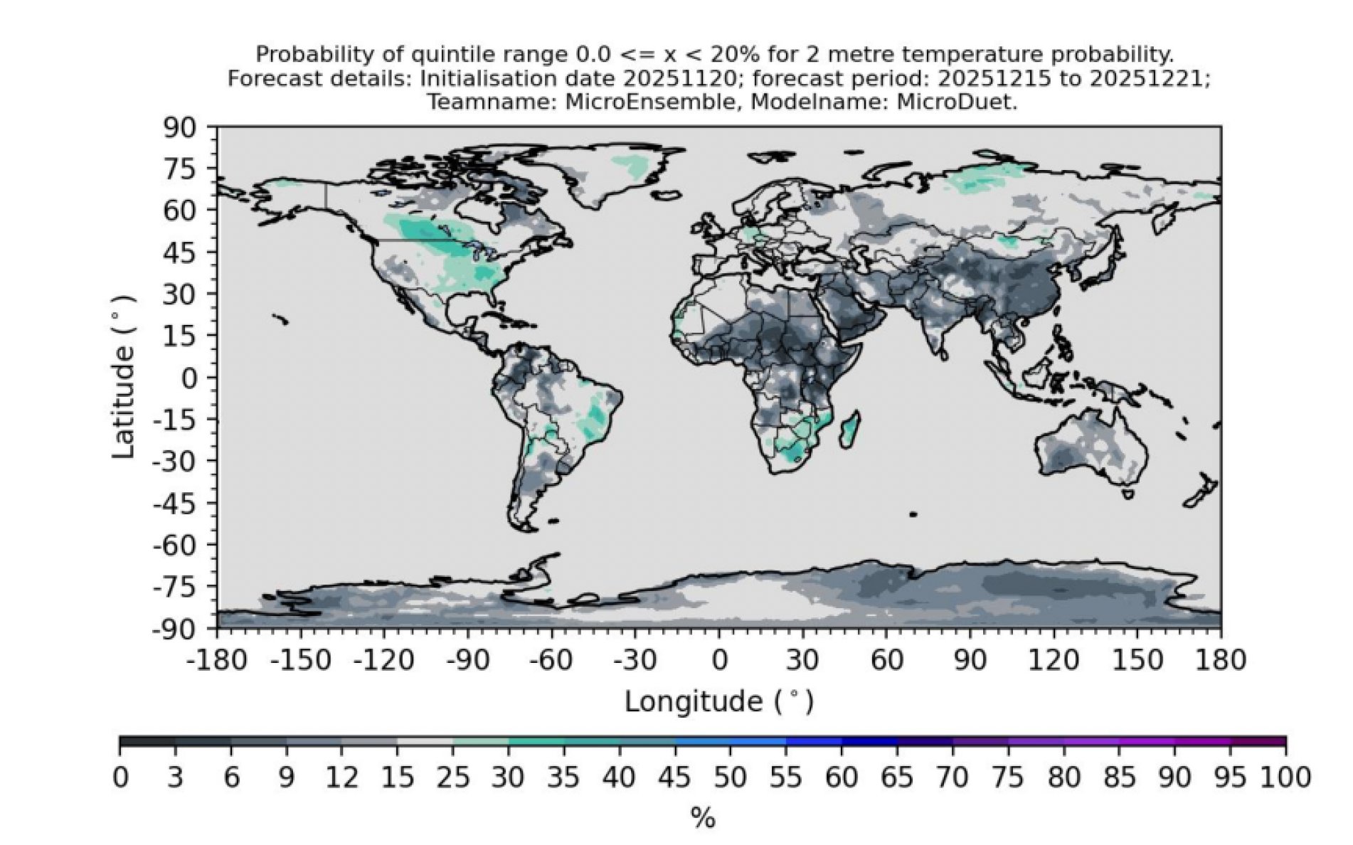
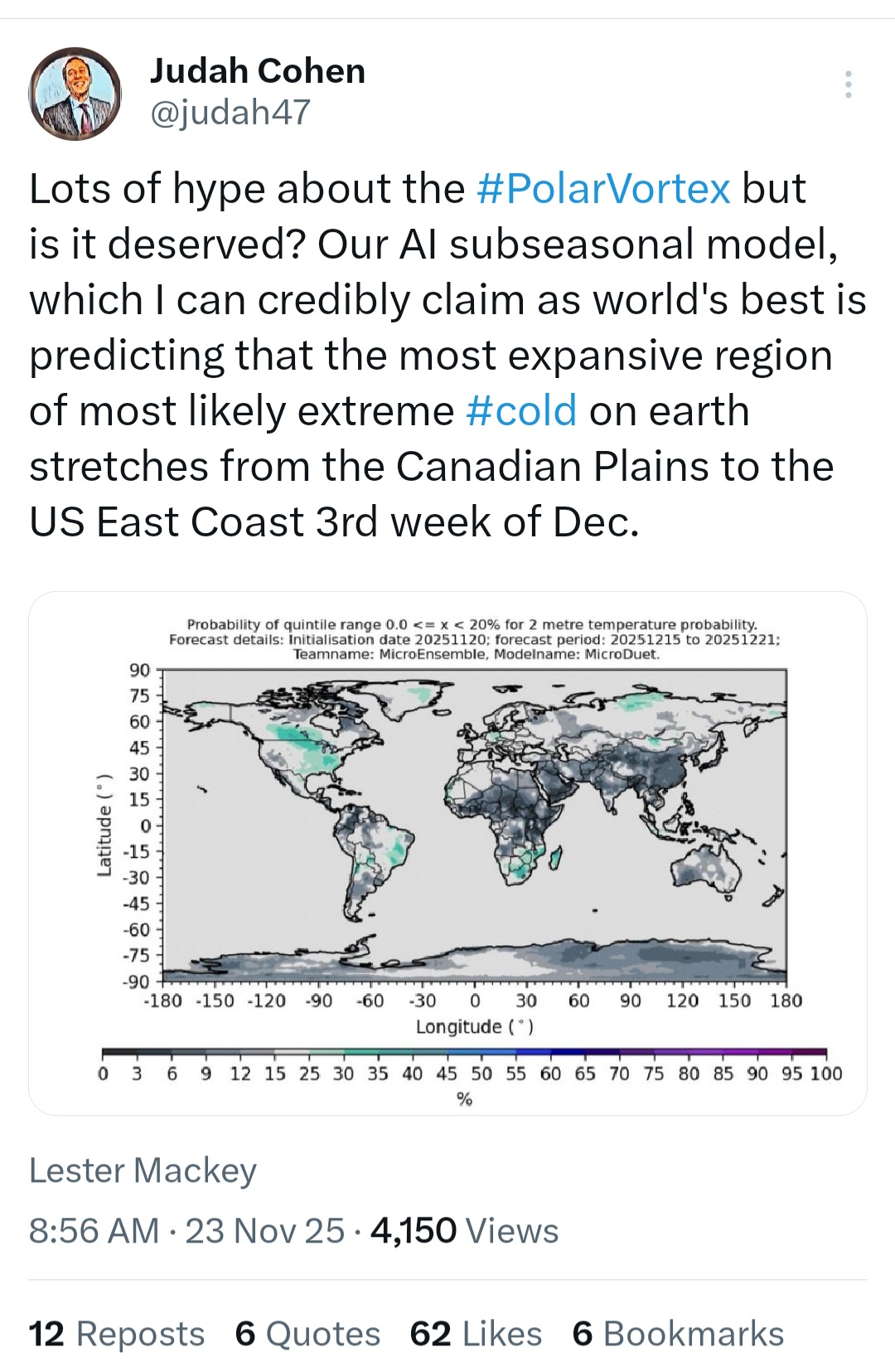
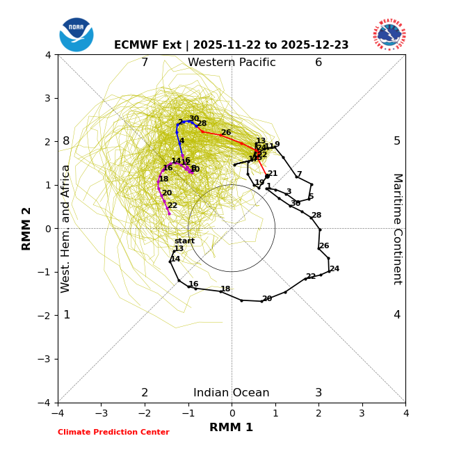
From https://x.com/judah47/status/1992608265507946858 Seems very reasonable. Third week of December looks good.

-
If we can get the thermal boundary to be squashed far enough south we might at least be able to begin with some wintry precipitation out ahead of any overrunning system around 11/30 (Thanksgiving weekend). The ICON and now GFS have been hinting at this scenario. The 0z CMC and ECM had a less defined mid-level shortwave (~day 6) between the prominent systems, but the EC-AI is somewhat supportive. This looks volatile in the modeling as there are strong waves upstream and downstream that will likely lead to major run-to-run changes. But I think there is a small hint of a pathway to something wintry before fantasy-range.
-
>> For comparison. >>
-
The ICON and GFS are coming in hot this morning for the end-of-week snow event. Both have potential for 6+" across Iowa and Illinois if the rates are heavy enough to counter the warm ground.
-
For future reference, based on MJO verification over the last 30 days, GEFS is really the one to watch when MJO is medium to high amplitude. And it’s not even competitive.
-
For future reference, based on MJO verification over the last 30 days, GEFS is really the one to watch when MJO is medium to high amplitude. And it’s not even competitive.
-

November 2025 general discussions and probable topic derailings ...
powderfreak replied to Typhoon Tip's topic in New England
Surprisingly decent snow this morning with the clipper warm front. ASOS down to 1 mile steady -SN. METAR KMVL 231545Z AUTO 00000KT 1SM -SN BR BKN020 OVC036 M01/M03 A2991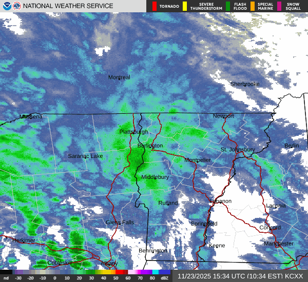
-
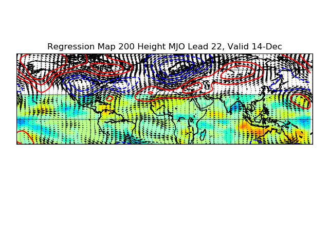
Paul Roundy's experiential MJO forecast tool has this look by DEC 14th...just updated. https://www.atmos.albany.edu/facstaff/roundy/waves/rmmcyc/indexmjo.htmlGree Very suppressed SER with big time -EPO & bridge block to Greenland.
-
27 this morning, all of the stubborn leaves dropped this morning.
-
https://x.com/judah47/status/1992608265507946858?t=ykLy8c-MkGuGLusD9eZevQ&s=19

-
Judging by the flip flopping some things never change with the models. Everyone take a breath, it’s not even Thanksgiving. We’re going to be fine. Dec looks volatile and then we have Jammin’ January and Fab Feb.
-

2025-2026 ENSO
michsnowfreak replied to 40/70 Benchmark's topic in Weather Forecasting and Discussion
People post from different regions so different effects are expected. Plus the select group of posters who always/only look for warm will be looking and scouring social media for whatever they need to to mitigate any cold. But overall appears that in typical nina fashion, the already cold north will have colder anomalies and the already warm south warmer ones. In other words big temp gradients, at least at times. - Today
-

November 2025 general discussions and probable topic derailings ...
WinterWolf replied to Typhoon Tip's topic in New England
Wrong! So WRONG. What’s being progged is nothing like last December. -
It actually went below freezing in east Queens this morning instead of scraping just above it like we have had several times already.
-
Looks like 3-6" potential starting tomorrow night. Followed by a decent chill for late Nov.
-

November 2025 general discussions and probable topic derailings ...
SnoSki14 replied to Typhoon Tip's topic in New England
It's been pretty much the same winter pattern for the last decade minus a few blips here and there. -
 How do you even know that ?