All Activity
- Past hour
-
And one would think as it gets closer to the coast, there’s room for even more tightening as friction with land starts to do its work.
-
 I had to delete my comment lol. I almost forgot we had snow otg for nearly the entire month of January. February wasn't terribly cold nor was December. I guess that's why it felt more mid. January was a 9 out of 10.
 -
Probably too late now for any weakening to lower the storm surge, as the waves have already built up. All that can be hoped for is that the winds back down a bit.
-
Dorian.
-
The convection continues to go nuts on IR.
-
Those mountains should help disrupt the circulation, and weaken Melissa before it moves on to Cuba.
-
In the spirit of @wncsnowand @Met1985, MJO is overrated, give me an optimal eastern pacific and I’ll take my chances.
-
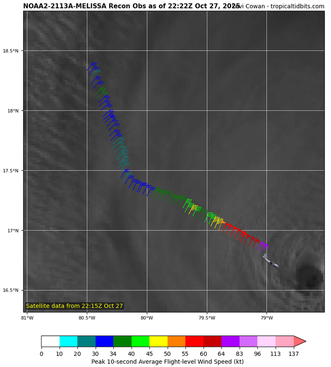
First pass shows no real structural changes. No evidence of an outer eyewall development and no real pressure changes. Winds about the same. Let’s see what’s in the NE eyewall. I will say from a sat perspective this is the best the storms has looked.
-
Noticed that too. Last several frames on IR go Nw-W-SW-S. Maybe a wobble but seems like it might be the turn. Landfall at Savanna La-mar is my guess.
-
 Last several GFS op cycles offering 4+ in a narrow band roughly MMU-POU... something to model monitor tomorrow. Likely my last on this til Tue am. Unsure whether PHI or OKX are looking at HSLC etc.
 -
This is a shot in the dark, but I'm kind of guessing this southern turn may be the start to a small loop before heading NW
-

Spooky Season (October Disco Thread)
ineedsnow replied to Prismshine Productions's topic in New England
910mb first pass.. think she peaks later tonight -
Additionally with the storm making landfall in W Jamaica that'll probably cause even greater rainfall and orographic lift on its east side, not to mention the entire island gets 20"+ amounts. NE movement ideal for surge too
-
There will be some wind so plenty of leaves will come down. And I have a lot yet to come down lol. All I have to do is look up at all those leaves. The blower is tuned up and ready.
-
Spooky Season (October Disco Thread)
ineedsnow replied to Prismshine Productions's topic in New England
Moving sw now -

Spooky Season (October Disco Thread)
dendrite replied to Prismshine Productions's topic in New England
-
One feature that continues to be a constant on all the extended products is an Aleutian trough and a +PNA, and to varying degrees a -NAO. We shall see how it plays but good signs for now as we head into early winter.
-

Spooky Season (October Disco Thread)
SnoSki14 replied to Prismshine Productions's topic in New England
That's usually an indication of a sharp turn coming shortly. I expect a N to even NNE turn soon. -
Think some foliage will survive through it?
-
I’d be more concerned about why I’m suddenly a farmer in the 1800s than the winter.
-

Spooky Season (October Disco Thread)
WinterWolf replied to Prismshine Productions's topic in New England
You’d be thrilled. -
That pressure gradient is insane. Reading 992 MB at this point
-

Spooky Season (October Disco Thread)
Damage In Tolland replied to Prismshine Productions's topic in New England
Maybe a move NW for 3 days then due north ? -
 So when they say you're a science teacher does that include knowing what an average is? Or actually does it include being able to look at literally any scientific papers from the last half century on the topic?
 -

Mid to long range discussion- 2025
WinstonSalemArlington replied to wncsnow's topic in Southeastern States
Threatening us with a good time


