All Activity
- Past hour
-
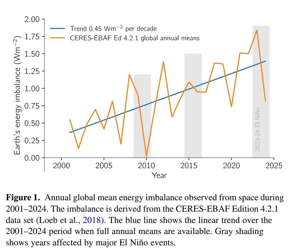
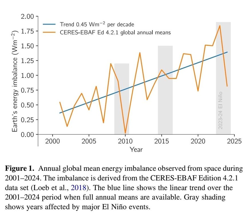
This chart shows the enso effect more clearly. Big dips in net radiation due to radiation to space occurred in 2010 and 2024 ninos. The correlation isn't perfect because there are other factors as well. Cloud cover for instance impacts the amount of sunlight that gets reflected back to space. Less clouds is contributing to the current increasing rate of heat build-up in the climate system. Reduced cloud cover is a positive feedback to warming temperatures. In-any-case the climate system isn't constant. As I pointed above, averaging over 11 years cancels out the short term variation.
-
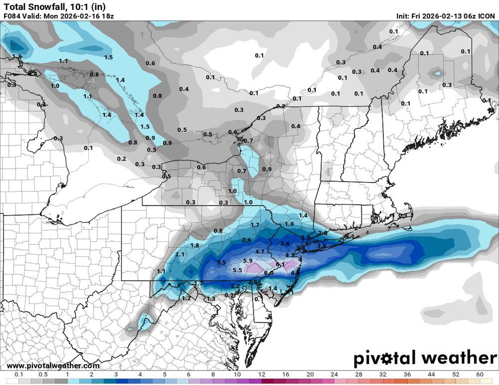
Based on what I can ascertain so far, it gets warm in the early part of the week, maybe a day with 10 above normal or something. Then a minor system moves towards us, which might be mixed perhaps on Wednesday. Then a bigger system, which looks like a swfe and redeveloper comes in for Friday and Saturday, which should be snowy up here and a little tough to say in southern New England.
-
Is mid and late week next week 1 system or 2?
-
I'd be cautious without a peer reviewed paper. There is a lot of misinformation on climate out there. We see it here all the time. Most of the published studies I've seen show a negative effect. One that will increase in the future. Warmth is a benefit in northern areas, but a negative further south. Here are a couple of links. https://www.nature.com/articles/s43017-023-00491-0 https://sustainability.stanford.edu/news/climate-change-cuts-global-crop-yields-even-when-farmers-adapt
-

E PA/NJ/DE Winter 2025-26 Obs/Discussion
PhiEaglesfan712 replied to LVblizzard's topic in Philadelphia Region
2020 was a warm and essentially snowless winter, which reversed to the mean, and turned cold in April and May. Same with 2023, which turned cold in May and June. We have nothing like that like this year. If we regress to the mean this year, it will be more like 2010, 2011, and 2015. All of those were cold and snowy winters, which turned warm in the spring. Yeah, none of this is going to happen. Polar vortex disruptions don't happen 2 weeks apart this late in the season. We're at best only going to get one of these. -
Flakes maybe, I certainly don't see inches
-
I was born in 1970. There were a couple that were cold for certain short periods, and many that almost felt like months of extended late fall. It was a terrible decade for winter, with just a select few notable events mixed in. Observed from my back yard, I didn't focus much broader at the time Selfish teen lol
-

Winter 2025-26 Medium/Long Range Discussion
A-L-E-K replied to michsnowfreak's topic in Lakes/Ohio Valley
Grb duh - Today
-
Icon/EPS will save us.... Knew more surprises were coming, I fully expect to be teased again at 06Z/12Z euro suite... Storm won't die
-
6z ICON EPS also

-
6z ICON was trying again
-
Icon !
.thumb.png.590cc22ad27bf1bf1559216b4d4964a6.png)
.thumb.png.8a368617f0c425f9aa288d0683d9a557.png)
-

E PA/NJ/DE Winter 2025-26 Obs/Discussion
Voyager replied to LVblizzard's topic in Philadelphia Region
I remember the May 2020 snow. It was the weekend I tore my rotator cuff. The high, I believe that Saturday, was only in the 30's, and we did have flurries and snow showers in Tamaqua. Of course there was no accumulation, but it was the first and only time I saw snow in May. -
Nam way south This storm is done
-
 End of the 0z Euro is warming up really good in the Midwest. Run it forward a few days and we might be talking about 70s. 117hr Euro is 57F in DCA 186hr Euro is 67F in DCA 288hr Euro is 64F in DCA 354hr Euro is 63F in DCA 4 separate fronts.. -PNA pattern Model run is probably too extreme, but it does highlight a warmer pattern coming up.
 -

Winter 2025-26 Medium/Long Range Discussion
RemoteSenses replied to michsnowfreak's topic in Lakes/Ohio Valley
I’m ready to be let down again. -
-
Ah I see said the blind man
-
Summary of 0z tonight: GFS: miss EURO: miss CMC: miss ICON: miss UKMET: miss NAM: miss RGEM: miss RRFS: miss GFS AI: miss EURO AI: miss EPS: miss GEFS: miss GEPS: miss EPS AI: miss UKMET ensemble: miss
-

Winter 2025-26 Medium/Long Range Discussion
Chicago Storm replied to michsnowfreak's topic in Lakes/Ohio Valley
the next window of opportunity is nearing for the sub-forum. we enter this window beginning mid-next week. some places are going to do really well in this pattern. who will it be? msp, grb, mke, ord, dtw? -
No one ever seriously thought we would get snow from 45 degree precipitation. The models have gotten stupider and so have we. .
-
A little dusting coming Saturday morning
-

Central PA Winter 25/26 Discussion and Obs
Ruin replied to MAG5035's topic in Upstate New York/Pennsylvania
LOL I feel its over for snow this year it was nice to have a nice blanket of white on the ground for this long. -
True, but I meant below zero down II my in CT. Here we may be able to pop a below zero number as far out as early April? This has been a big year for below zero temps. I love it. -1.5/-5 here right now. -8 at SLK.
-
A lot of bad tracks/cutters. Cold, warm up rain, cold again. Or front end snow to mix to freezing rain to rain, then get cold again and freeze everything up. Lots of good sledding/sliding back then for sure, due to the icy hard snow conditions. Lots of fun in that regard.