All Activity
- Past hour
-

Spooky Season (October Disco Thread)
Typhoon Tip replied to Prismshine Productions's topic in New England
at a glance we're frosting in the interior in SNE's climo cold spots dunnite. should have no issues decoupling with DPs in the 35-40 range under gaping wound heat hemorrhaging sky. not sure if the DPs do that 7 pm bounce back -

Central PA Fall Discussions and Obs
Jns2183 replied to ChescoWx's topic in Upstate New York/Pennsylvania
In 1963 we no fall. Average high temperatures in October for the month were a ridiculous 71.7, a plus 6 departure from Normal. It hit 87 on October 7th. In total 5 days were 80 or above and an insane 15 were 75. The mean high temperature was 4th highest all time. Our lows however were a negative 3.5 from normal at 42.5. The reason? Not only did we have the driest October on record, but it was also the single driest month ever, and still is, at 0.04". My dear weather nerds, what followed was pure beauty of snow starting December 10. Following is December to March snow 15.8 19.4 30.2 9.0 Sent from my SM-X210 using Tapatalk -

September 2025 OBS-Discussion centered NYC subforum
LibertyBell replied to wdrag's topic in New York City Metro
Interesting, everything is shifting to January as February has been getting warmer at a more rapid rate. -
the wind made it bad but now it's good no more wind
-
Three of my favorite summers in this list-- 1966, 1999, 1993. Why not 2002? 2022 was not hot in any memorable way though.
-
2022 wasn't that hot though 1999 definitely was, I have great memories of that wonderful summer!!
-

Occasional Thoughts on Climate Change
donsutherland1 replied to donsutherland1's topic in Climate Change
It was the wettest monsoon season in Phoenix since 2021 and biggest one- and two-day rainfalls since October 2018. -
Also can vary quite a bit locally. According to that, CO just had our 11th warmest summer on record, but here on the Front Range, it was only slightly warmer than the 30 year average. Including September and May, it was one of the coolest warm seasons of the past 15 years, so it really did feel mild...even if it would have qualified as a very warm summer 40 years ago.
-
The GFS is waffling on a strong cold front mid-month. Sometimes it has it, others it doesn't. 0z had frost in the area by the 16th. 12z is torchy.
- Today
-
27.3F for a low here... not quite the coldest we've had, but close
-
This observation from the Phoenix NWS matches the recent study as to how quickly people normalize extreme weather. It’s one of the reasons that climate change is pretty far down on the list of priorities for many. Phoenix is still one of the fastest growing metro areas in the country. https://www.universityofcalifornia.edu/news/how-quickly-we-normalize-extreme-weather The study, published Feb. 25 in the journal Proceedings of the National Academy of Sciences, indicates that people have short memories when it comes to what they consider “normal” weather. On average, people base their idea of normal weather on what has happened in just the past two to eight years. This disconnect with the historical climate record may obscure the public’s perception of climate change. “There’s a risk that we’ll quickly normalize conditions we don’t want to normalize,” said lead author Frances C. Moore, an assistant professor in the UC Davis Department of Environmental Science and Policy. “We are experiencing conditions that are historically extreme, but they might not feel particularly unusual if we tend to forget what happened more than about five years ago.
-
Yuck. @Holston_River_Rambler, the big red ball over the Aleutians is there for three straight months. Let's hope the CANSIPS is wrong. Next month is the the one with the most skill. I don't like this at all. November looked good. October isn't a bad look, but I think it stays warm. @nrgjeff, if we are talking talking basketball....this is the equivalent of Kansas making the NIT, right?
-
70 degrees here and not a cloud in the sky. Great way to start October. I'm leaving right now for bow hunting for the first time this season. Perfect weather for it.
-
let it snow (in canada)
-
I thought for sure we were going to miss extended summer this year. Nope. October could well be VERY warm. That does likely set us up for a very sharp flip come November if past Nina years are any clue.
-

Spooky Season (October Disco Thread)
SouthCoastMA replied to Prismshine Productions's topic in New England
We would take this onshore flow in December/January Recording 2025-10-01 134409.mp4 -
Yes, this is what I mean. Keep the dry pattern going through Winter and come Spring we will be significantly below normal. Long ways to go but pattern has been rather persistent. If we get lots of suppression from high pressure to our north as we move through Fall and Winter it will keep the dry pattern going. Very possible.
-
And you're a Bengals fan. How in the hell are you not an alcoholic?
-
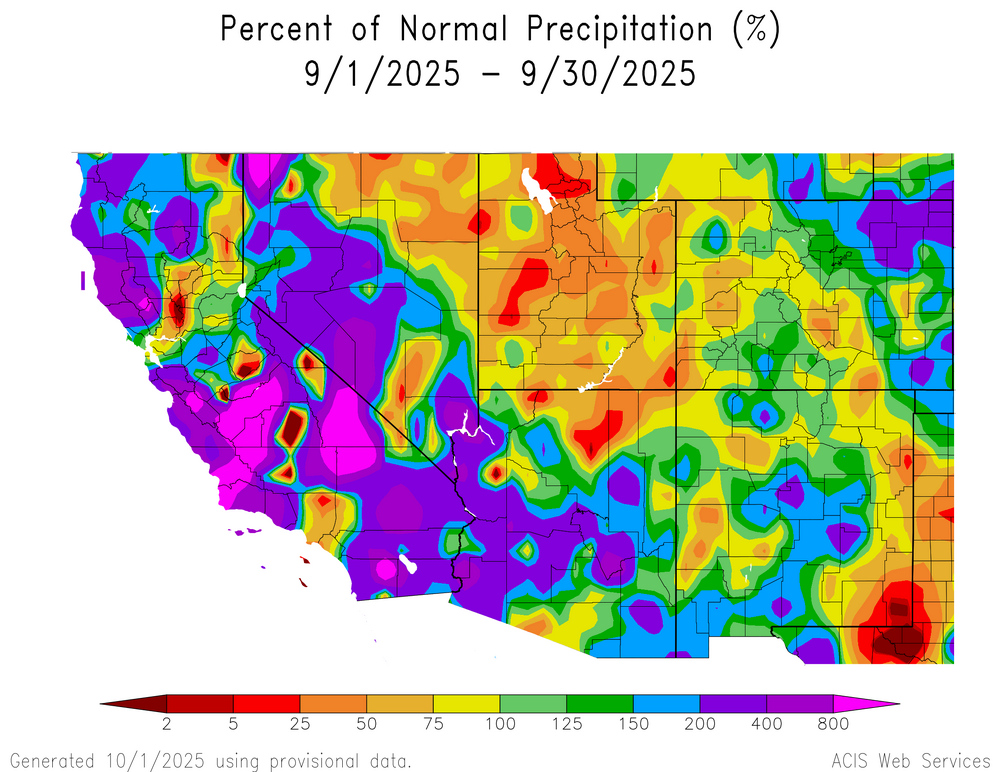
Looks like it was a pretty wet month overall for much of AZ, CA, and NV. Second wettest September for Phoenix since 1984, and I'm sure even more impressive some other places.
-
So what's the new climate change strategy? Let er rip? Good grief... we deserve every adverse scenario we get going forward. We sold our souls and mailed in a nice planet for likes, shares, followers, and subscribers.
-
DEN finished September almost exactly normal, with a -.1 departure. Precip was also above normal for the second month in a row, though nowhere as anomalous as August.
-
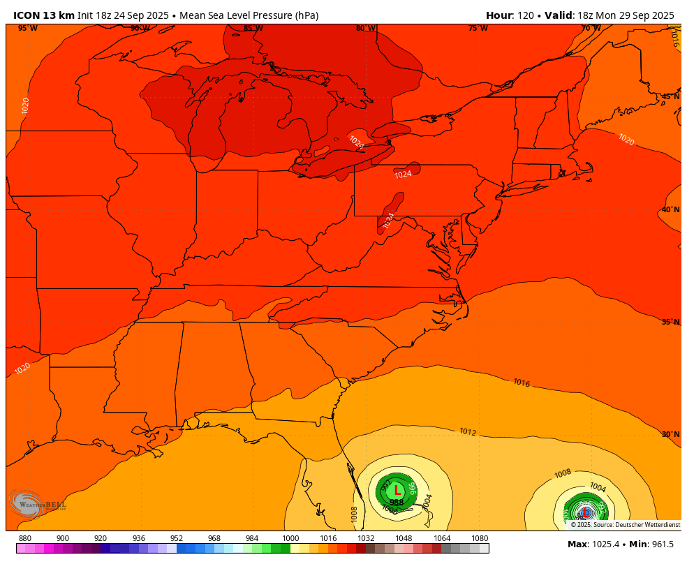
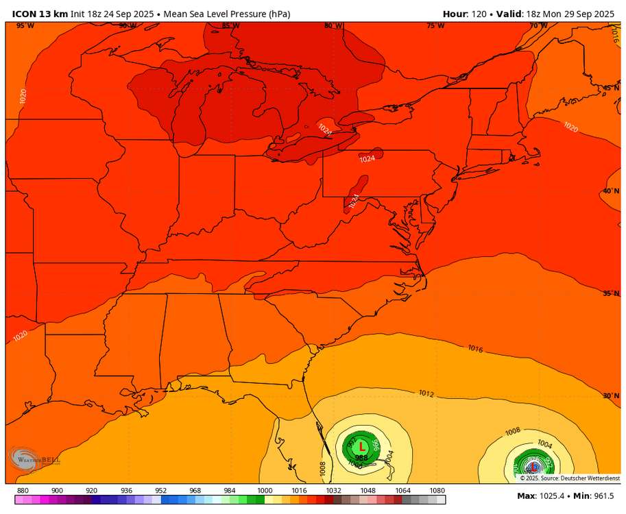
The ICON and UKMET were absolutely stellar in that neither model had even one run hitting the coast or even stalling at the coast. None ever got closer than 100 miles from the US. I made sure to post every UKMET with a TC as well as any Icon that nobody else posted. All of the UKMET runs 12Z of 9/23 through 0Z 9/28 run (except 0Z of 9/24, which had no TC) in textual form can be seen ITT. The Icons going back to 12Z on 9/24 are still on Tropical Tidbits: https://www.tropicaltidbits.com/analysis/models/ ICON: The only Icon that I don’t know with 100% certainty is the 18Z of 9/24 because it goes out only 120 and is then moving very slowly NW toward C FL at ~79.0W (see 1st quoted post above). But even it is slowing down 100 miles offshore FL, the closest of any ICON to the US, and quite possibly about to make the hook OTS. UKMET: The other 4 quotes are of the furthest west UK runs. The two 9/25 runs move to 78.3W. Then the 9/26 12Z and 9/27 0Z move to 78.5W, the furthest W runs. All others’ furthest W were 77.1-77.4W. The closest to the US of any UKMET run was 115 miles E of Ft. Lauderdale (0Z 9/25 run). Furthest W of each UKMET run: 9/23 12Z: 77.1W 9/24 0Z: no TC 9/24 12Z: 77.2W 9/25 0Z/12Z: 78.3W 9/26 0Z: 77.3W 9/26 12Z and 9/27 0Z: 78.5W 9/27 12Z: 77.3W 9/28 0Z: 77.4W Whereas the UK’s record on the tracks was the best of all models (even better than the Icon), it was the latest on first having it as an actual TC (12Z 9/23) and also it didn’t have it on the 0Z 9/24. So, it was too genesis shy very early on, which is not uncommon with it. That’s why I pay extra attention when the UKMET first has a TC. Aside: The UKMET (#1) and ICON (#2) were also by far the best with Ian (‘22). ———— Honorable mention for JMA, which had only one run hit the US (NC). But like the UKMET, it was a bit shy early on in showing a TC. Despite its pretty poor record on the track along with Euro and CMC, an honorable mention is due for the GFS for showing Imelda as far back as one 9/19 run, way earlier than any other model, even though it lost it for a couple of days after that run. * Imelda’s actual furthest W was 77.3W. @WxWatcher007
-
things are going to definitely get more active starting next week. enjoy the summer temps while you can
-

Summer 2025 Medium/Long Range Discussion
madwx replied to Chicago Storm's topic in Lakes/Ohio Valley
the last 2/3rds of the month were much above average, led to a +3.0 departure for the month. 26th warmest September on record