All Activity
- Past hour
-

2026-2027 Record-breaking El Nino
LakePaste25 replied to Stormchaserchuck1's topic in Weather Forecasting and Discussion
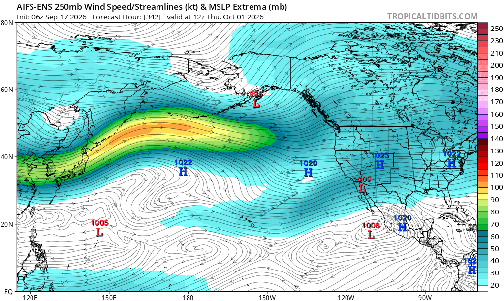
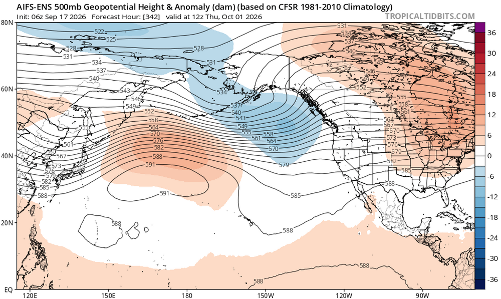
You can tell we are slowly getting to that warm ENSO state. Plenty of +U in the NH. Still some residual ridging out west of the Aleutians but even that’s weakening and probably flattens out with time.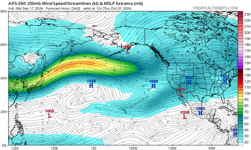
-
Fall 2026 Medium/Long Range Pattern Thread
Daniel Boone replied to John1122's topic in Tennessee Valley
It's the big Heat Dome that plagued the Southern Plains all Summer. Question is, will it finally dissolve, shift Eastward out into the Atlantic, become a Bermuda High, weaken then rebound etc.. The back Westward shift.is unlikely as the STJ should barrel into the SW. Come Winter, if there's any semblance of this Feature,whether stll alive(low odds) or ressurrected, it could have quite an effect, especially if it becomes formidable then. IF it were to it would probably setup in the SW Atlantic due to the STJ forcing. Where out there would determine our Pattern Outcome; out by the Sargasso Sea would be great if you want Snow. Further West mild and probably wet. -
Warm/dry, cold/wet?
-

2026-2027 Record-breaking El Nino
Winter Wizard replied to Stormchaserchuck1's topic in Weather Forecasting and Discussion
An interesting thing about the GLAAM is that when it's plotted on a latitudinal basis, it's actually shown to be strongly in the negative direction around the mid-latitudes. It almost looks like a glitch but it has been moderately to strongly negative at various other points since July. Perhaps some interference somewhere? -
BAM is anticipating an Omega block to form next week. https://x.com/bam_weather/status/2100011954584617218
-
That's pretty typical in the warmer months, though, right? That said, this has been one of the most humid summers that I can recall...certainly since those legendary summers of 2017 and 2018. What we're really missing are those southern storms or even tropical remnants, but the overall base state airmass since spring implies we may get more of those this year.
-
Showers and storms a bit early?
-
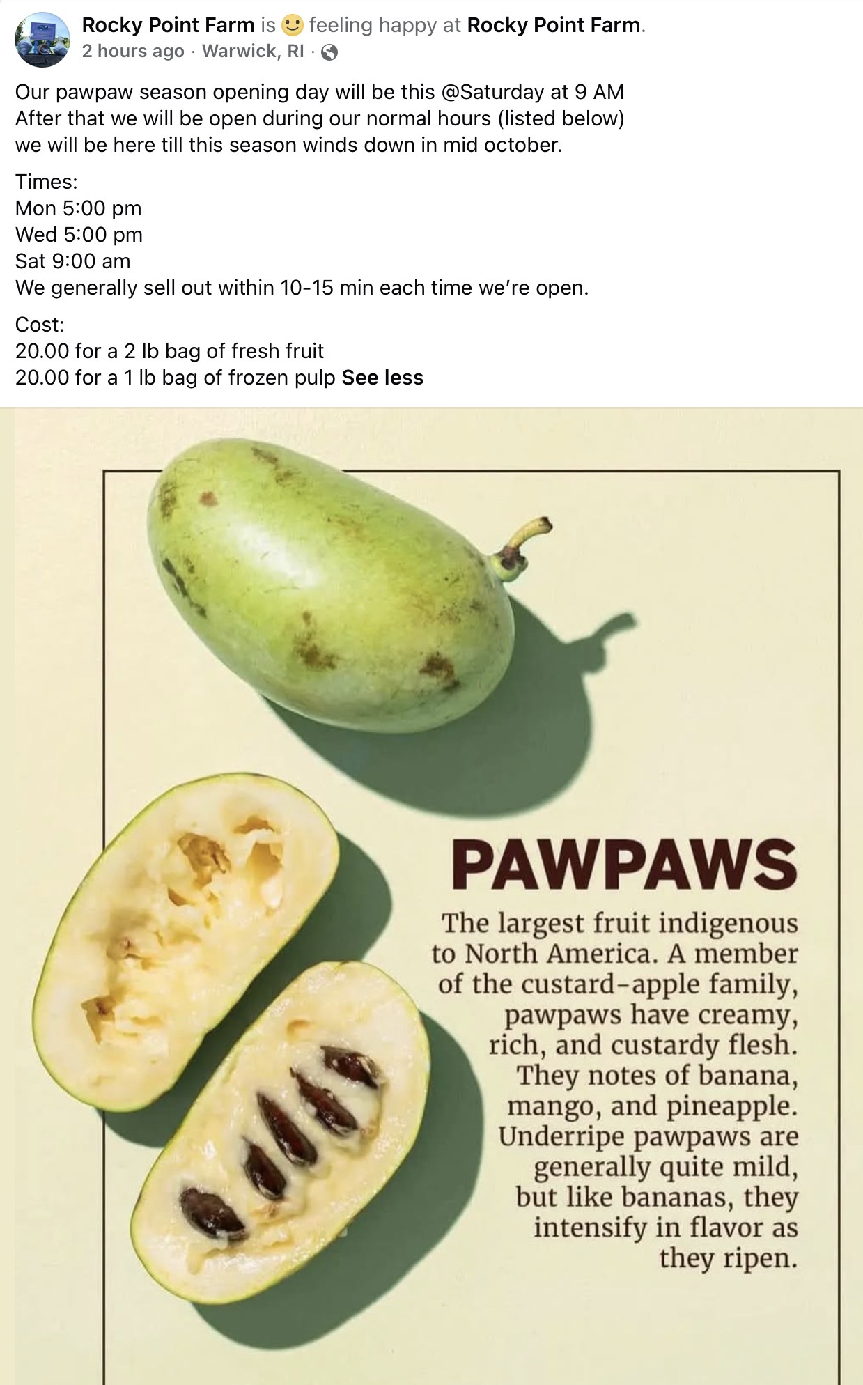
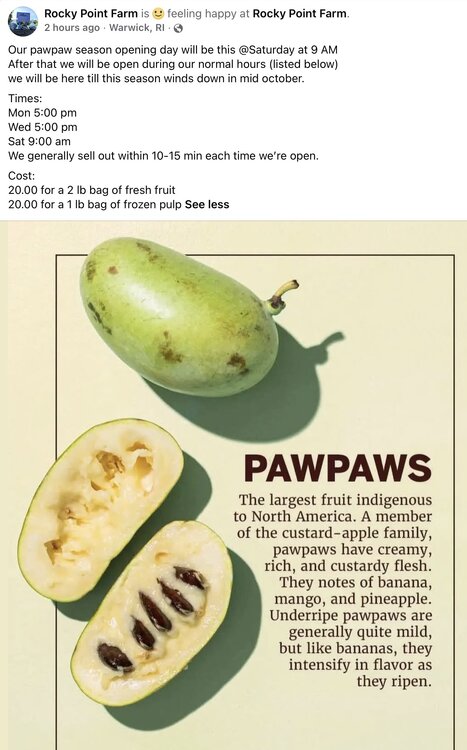
For those in RI, E CT, and SE MA that want to try pawpaws
-

Central PA Summer 2026 Discussion/Obs Thread
TheDreamTraveler replied to Voyager's topic in Upstate New York/Pennsylvania
Next week is going to feel very fall with highs in the 60's and rain. I'm kind of looking forward to it honestly but I'm also one of those weird ones that like long cool rainy days -
There is a chance that this is ushering in the pattern change.
-
We’ve had worse torchmases
-

Septorcher 2026 Discussion - Endless Summer
RCola replied to Damage In Tolland's topic in New England
It's part of his reverse psychology strategy. -
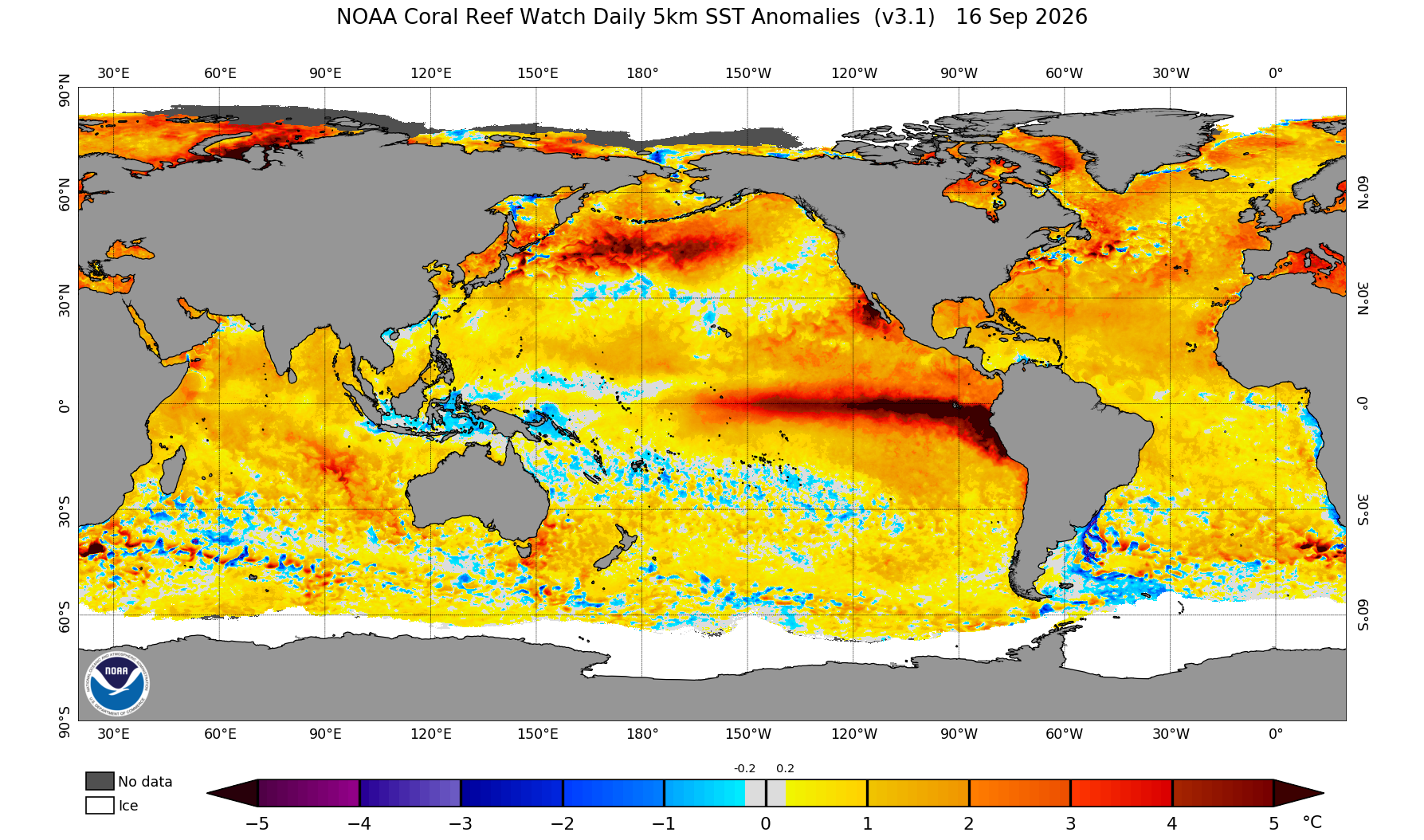
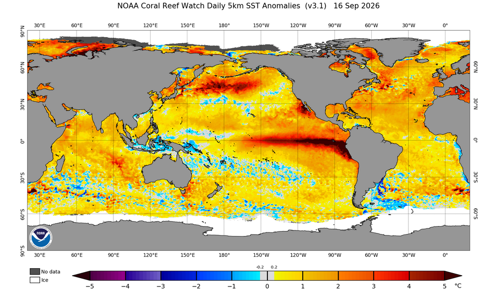
Just looking at the real time Pac ssta plots makes it really hard (for me) to make a case for a remotely cold December. PDO index #s have trended less hostile but thats only a numerical index.... the visual of the Pac is quite hostile still and it's a long ways away from what we consider a favorable enso/pdo combo.... There's a lot of rippin deep red where we want anything but lol As fall progresses it should continue to cool and reconfigure towards at least a semi normal Npac during a Nino but its hard to ignore how ugly the Npac is right now. Its hard to imagine a favorable pac pattern setting in quick for the Eastern conus. This is one of the main reasons I think the Dec CFS idea makes sense.
-
I deleted my post re the Cfs2 as it seems the Cfs2 site is stuck on 9/12. Looks like TT, as of today’s link, is more current. Those government guys are tricky!
-
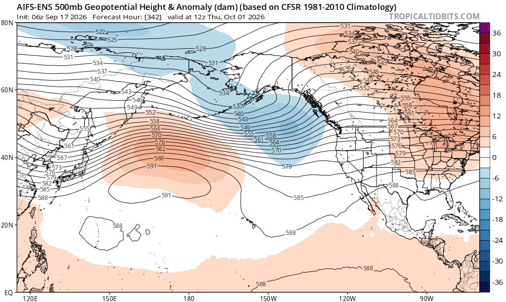
That's a pretty ugly 500mb chart for December. Hello 65 and sunny on Christmas.
- Today
-
"When in doubt, forecast drought."
-

2026 Atlantic Hurricane Season
PhiEaglesfan712 replied to Stormchaserchuck1's topic in Tropical Headquarters
I think it was last year, we didn't have a TC from August 28-September 16. [The year before, we didn't have a TC from August 21-September 8.] -
CAD seems likely. I'm more interested in what may potentially develop in the Gulf or off the SE Coast. Euro and other models hinting at something. Potential heavy rains.
-

2026-2027 Record-breaking El Nino
40/70 Benchmark replied to Stormchaserchuck1's topic in Weather Forecasting and Discussion
Basically, high AAM means that the hemisphere is more representative of warm ENSO, low AAM cool ENSO. -

2026-2027 Record-breaking El Nino
soadforecasterx replied to Stormchaserchuck1's topic in Weather Forecasting and Discussion
Seems like we are still seeing some good heating going on to push this el nino stronger.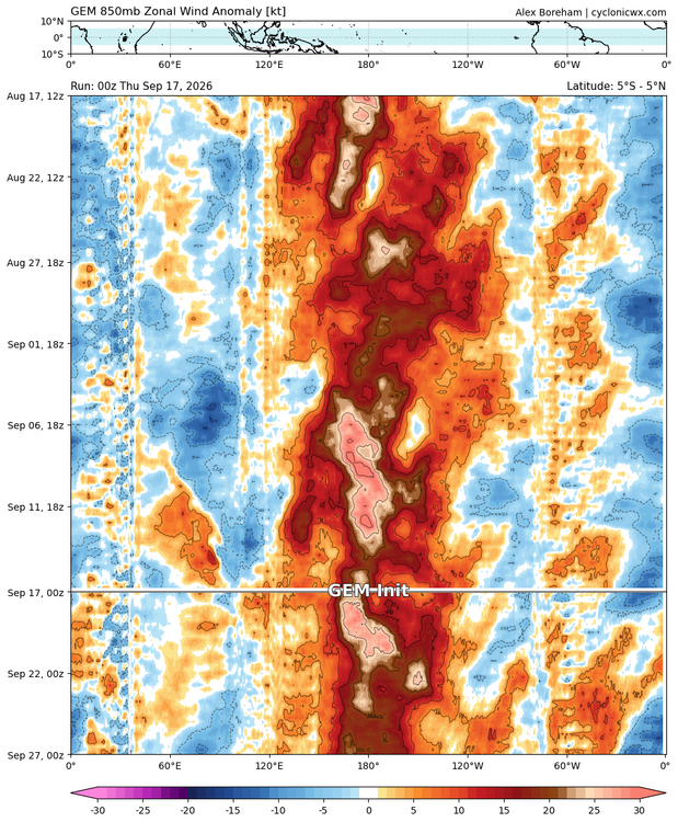
-

Pittsburgh PA Summer 2026 Thread
Gordo74 replied to TheClimateChanger's topic in Upstate New York/Pennsylvania
Might make e11 shirts to manifest that one into existence. -
 Hi everyone! I stumbled upon a really useful site and figured I'd pass it along. Check it out — https://silverwillow.com/. Would love your feedback
 -
2026-2027 Record-breaking El Nino
soadforecasterx replied to Stormchaserchuck1's topic in Weather Forecasting and Discussion
Climate Drivers: Anomalously high relative AAM values frequently occur during El Niño events and specific active phases of the Madden-Julian Oscillation (MJO) due to broad westerly wind anomalies in the tropics and subtropics. -

2026-2027 Record-breaking El Nino
mitchnick replied to Stormchaserchuck1's topic in Weather Forecasting and Discussion
Try "Global Relative AAM" -
The most glaring commonality between the QBO composite and both the solar and intense El Niño composites is the pronounced ridging stretching from the northeastern CONUS and into central Canada, which obviously is a rather mild signal for the forecast area in the seasonal mean. However, it has been mentioned on numerous occasions that neither of these winter composites are entirely bereft of high latitude blocking or even shorts bursts of severe winter weather. This is evident in the bifurcation of the composite below. This is a signal that is emergent among some seasonal guidance. What is clear is that as El Niño begins to wane and perhaps shift somewhat to the west as the season evolves, the Gulf of Alaska low begins to retrograde, which allows the central Canadian-Northeastern CONUS ridge to lift up into the NAO domain. This mid-to-latter season progression is the crux of the volatility and Modoki-like episode(s) that have been referenced with the respect the overall characterization of the polar domain. The primary risk here for a transition to a significantly colder pattern is that the block is more oriented towards the Eastern portion of the NAO domain, which is especially evident in the more meager El Niño analogs that did not have the very cohesive Gulf of Alaska low that is synonymous with El Niño. The inference is that the development of the more Modoki like intervals during the second half of the season is contingent on the progression of the mid latitudes of the northern Hemisphere growing more redolent of traditional El Niño as boreal winter ensues, which should take place given the forecast for this warm ENSO event to reach an unprecedented magnitude as Mother Nature gives her best shot at the redistribution of that stagnant west Pacific warm pool