All Activity
- Past hour
-
URGENT - IMMEDIATE BROADCAST REQUESTED Severe Thunderstorm Watch Number 441 NWS Storm Prediction Center Norman OK 125 PM EDT Thu Jun 19 2025 The NWS Storm Prediction Center has issued a * Severe Thunderstorm Watch for portions of Connecticut Western and Central Massachusetts Northern New Jersey Eastern New York Northeast Pennsylvania Vermont Coastal Waters * Effective this Thursday afternoon and evening from 125 PM until 900 PM EDT. * Primary threats include... Scattered damaging wind gusts to 60 mph likely Isolated large hail events to 1 inch in diameter possible SUMMARY...Thunderstorms will intensify this afternoon in a very moist and unstable air mass. The strongest cells will pose a risk of damaging wind gusts and hail. The severe thunderstorm watch area is approximately along and 60 statute miles east and west of a line from 40 miles northwest of Newport VT to 60 miles southeast of Wilkesbarre PA. For a complete depiction of the watch see the associated watch outline update (WOUS64 KWNS WOU1).
-
Wingaersheik is cool but the parking situation is horrendous, especially coming from out here. And unless you're renting a house w/ a parking sticker a lot of the Cape bay beaches are no goes as well. Marconi and Coast Guard, also Salisbury are really the best bets for access. Even Misquamicut can be tough at times in spite of that huge lot.
-
415 ACUS11 KWNS 191722 SWOMCD SPC MCD 191722 NJZ000-PAZ000-DEZ000-MDZ000-VAZ000-DCZ000-WVZ000-191915- MESOSCALE DISCUSSION 1364 NWS STORM PREDICTION CENTER NORMAN OK 1222 PM CDT THU JUN 19 2025 AREAS AFFECTED...MID-ATLANTIC REGION CONCERNING...SEVERE POTENTIAL...WATCH LIKELY VALID 191722Z - 191915Z PROBABILITY OF WATCH ISSUANCE...80 PERCENT SUMMARY...CONVECTION WILL GRADUALLY INTENSIFY AS THEY MOVE OFF THE BLUE RIDGE THIS AFTERNOON. DAMAGING WINDS ARE THE PRIMARY HAZARD, THOUGH ISOLATED LARGE HAIL AND A BRIEF TORNADO OR TWO ARE ALSO POSSIBLE. A WATCH IS LIKELY. DISCUSSION...VISIBLE SATELLITE SHOWS CONVECTION GRADUALLY DEEPENING ALONG THE BLUE RIDGE IN ADVANCE OF AN UPPER-LEVEL TROUGH. GIVEN THE UPPER 60S TO LOW 70S F DEWPOINTS AND CLEAR SKIES AHEAD OF THIS ACTIVITY, THE BOUNDARY-LAYER WILL CONTINUE TO DESTABILIZE THROUGH THE AFTERNOON. 30-35 KTS OF EFFECTIVE SHEAR WILL LIKELY MEAN BROKEN LINE SEGMENTS AS WELL AS A FEW SUPERCELLS. THE PRIMARY HAZARD THIS AFTERNOON WILL BE DAMAGING WINDS, PARTICULARLY WITH ANY LINE SEGMENTS THAT DEVELOP. ISOLATED LARGE HAIL IS POSSIBLE, BUT WEAK WINDS AT UPPER LEVELS AND POOR MID-LEVEL LAPSE RATES (SAMPLE BY MORNING SOUNDINGS ACROSS THE REGION) SHOULD LIMIT THAT THREAT. MODEST ENHANCEMENT TO THE 850 MB WINDS WILL PROMOTE SUFFICIENT LOW-LEVEL SHEAR FOR THE THREAT OF A BRIEF TORNADO OR TWO. ..WENDT/HART.. 06/19/2025 ..PLEASE SEE WWW.SPC.NOAA.GOV FOR GRAPHIC PRODUCT ATTN...WFO...PHI...AKQ...CTP...LWX...RNK...PBZ...RLX... LAT...LON 37618051 38657993 40287794 40817698 40697497 40177473 37627670 36947781 36707996 37018057 37618051 MOST PROBABLE PEAK TORNADO INTENSITY...UP TO 95 MPH MOST PROBABLE PEAK WIND GUST...55-70 MPH MOST PROBABLE PEAK HAIL SIZE...UP TO 1.25 IN
-
SEVERE THUNDERSTORM WATCH OUTLINE UPDATE FOR WS 441 NWS STORM PREDICTION CENTER NORMAN OK 125 PM EDT THU JUN 19 2025 SEVERE THUNDERSTORM WATCH 441 IS IN EFFECT UNTIL 900 PM EDT FOR THE FOLLOWING LOCATIONS NYC001-005-007-017-019-021-025-027-031-033-035-039-041-043-047- 057-059-061-071-077-079-081-083-085-087-089-091-093-095-105-111- 113-115-119-200100- /O.NEW.KWNS.SV.A.0441.250619T1725Z-250620T0100Z/ NY . NEW YORK COUNTIES INCLUDED ARE ALBANY BRONX BROOME CHENANGO CLINTON COLUMBIA DELAWARE DUTCHESS ESSEX FRANKLIN FULTON GREENE HAMILTON HERKIMER KINGS MONTGOMERY NASSAU NEW YORK (MANHATTAN) ORANGE OTSEGO PUTNAM QUEENS RENSSELAER RICHMOND ROCKLAND SARATOGA SCHENECTADY SCHOHARIE ST. LAWRENCE SULLIVAN ULSTER WARREN WASHINGTON WESTCHESTER
-
Wiz got his watch
-
Watch up Weak watch at that lol
-
Knew it didn’t read well, but figured I could avoid a sick joke involving my 72 y/o MIL. Apparently not.
-
Finally MCD'd.
-
It looks like a hefty line is forming in western VA. I'm surprised there's not a watch box yet.
-
Meso discussion out Mesoscale Discussion 1363 NWS Storm Prediction Center Norman OK 1144 AM CDT Thu Jun 19 2025 Areas affected...portions of the Northeast Concerning...Severe potential...Watch likely Valid 191644Z - 191815Z Probability of Watch Issuance...80 percent SUMMARY...Scattered strong to severe storms are expected this afternoon with a primary threat of damaging wind gusts. DISCUSSION...Visible satellite imagery shows deepening towering cumulus across central and eastern New York amid moderate instability in an uncapped environment. As storms deepen, some organization/updraft rotation is expected given moderate shear (50 knots at 3km per ENX VWP). Damaging wind gusts and isolated large hail will be the primary threat from this activity. Storm coverage may be somewhat isolated early this afternoon as the upper-level trough and surface front remain across the eastern Great Lakes/southern Ontario. Additional storms may arrive this evening as those features move east, but instability will likely be weaker by this time, and the severe threat remains questionable by later this evening. ..Bentley/Hart.. 06/19/2025 ...Please see www.spc.noaa.gov for graphic product... ATTN...WFO...GYX...BOX...BTV...OKX...ALY..
-

E PA/NJ/DE Summer 2025 Obs/Discussion
BBasile replied to Hurricane Agnes's topic in Philadelphia Region
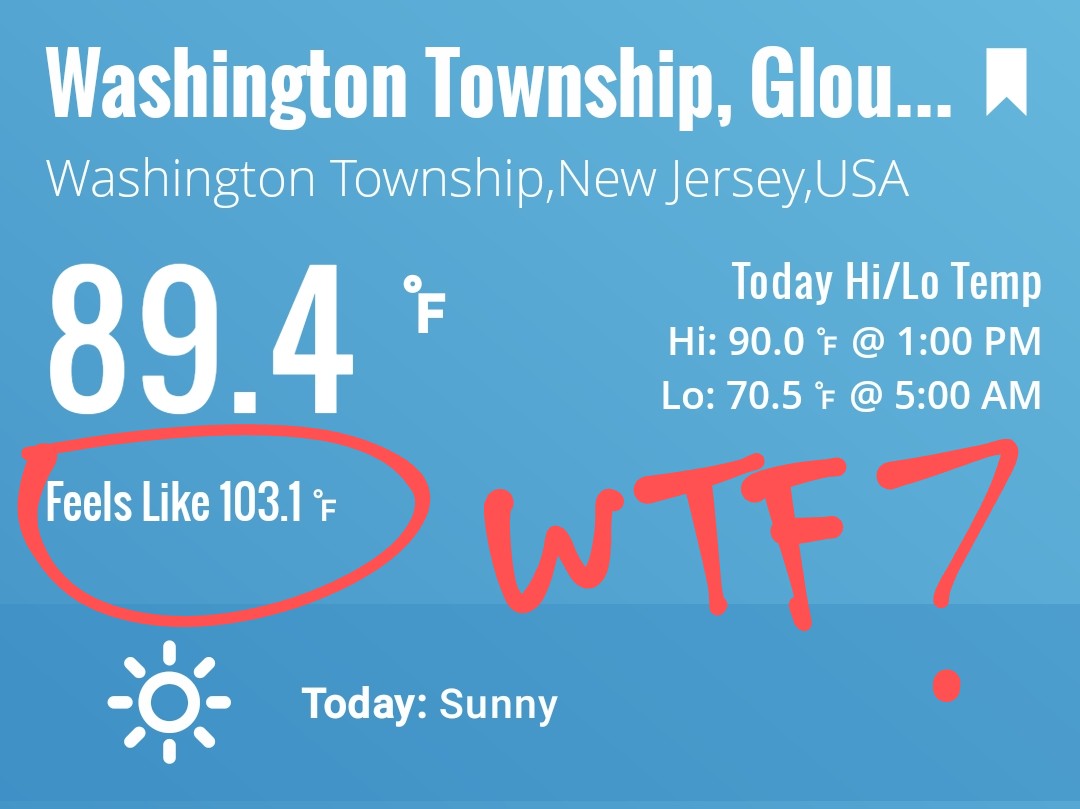
First 90F day of the year and it's torturous. After a week of 60F days. Thunderstorms are required after this.
-
read this one quick and, yikes. you did what?
-
I brought my daughter down a couple years ago and we stopped in at Skaket Beach near low tide. I forgot how crazy it gets with the tide...just sand for like a mile into the bay. Should be back in August staying at a place on Pamet Harbor in Truro.
-
RIP to those who didn't listen to Kevin.
-
Yeah, i'm good with that mess. Usually when the beaches are jammed, I'll park at one of the road shoulders at Rye and set up shop on one of the rocks. lol
-
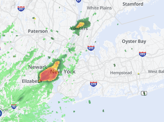
Storm cells popping up in NJ and moving in the area earlier than modelled. We might be in for a stormy afternoon.
-
 You may still enter the contest until 0200h EDT (06z June 20) ... I am posting this now to give last-minute entrants and current forecasters a quick overview of forecasts already made ... so far twenty have entered and all have managed to find a unique set of values.The consensus as median involves rounding two of four values up, I will probably change the contest consensus to a mean value if it gives a better set of numbers. At 0200h or a few minutes later, I will edit out this table and post it after all on-time forecasts that may be placed below in the thread. __ Table of entries __ 2025 seasonal max __ FORECASTER _________________ DCA _IAD _BWI _RIC gopper (16) ____________________ 103 _ 102 _ 102 _ 102 batmanbrad (19) _______________ 103 _ 101 _ 102 _ 100 Roger Ramjet (20) _____________ 102 _ 101 _ 103 _ 103 tplbge (14) _____________________ 102 _ 100 _ 101 _ 101 DanTheMan (8) ________________ 101 _ 103 _ 104 _ 103 Roger Smith (1) _________________ 101 _ 101 _ 102 _ 100 GramaxRefugee (18) ____________100 _ 101 _ 102 _ 101 biodhokie (17) __________________ 100 _ 101 _ 101 _ 100 wxdude64 (13) _________________ 100 _ 100 _ 102 _ 100 George BM (2) _________________ 100 __ 99 _ 101 _ 101 ___ consensus _________________ 99 __ 99 _ 100 _ 100 MillvilleWx (7) ___________________ 99 __ 99 _ 100 _ 102 Rhino16 (5) ______________________ 99 __ 99 __ 99 _ 101 Jenkins Jinkies (9) ______________ 99 __ 99 __ 99 _ 100 NorthArlington101 (6) ____________99 __ 99 __ 99 __ 99 RickinBaltimore (10) _____________ 99 __ 98 __ 98 __ 99 WxUSAF (4) _____________________ 99 __ 97 _ 100 __ 99 toolsheds (12) ___________________ 99 __ 97 __ 99 _ 101 Weather53 (21) __________________ 98 __ 99 _ 100 __ 99 nw baltimore wx (3) _____________ 98 __ 98 __ 99 __ 99 Its A Breeze (11) _________________ 98 __ 98 __ 98 __ 99 Prince Frederick Wx (15) ________ 98 __ 97 __ 98 __ 98 ____________________________ Consensus is median of forecasts. The mean of forecasts is 99.9, 99.5, 100.4, 100.3 or 100 _ 100 _ 100 _ 100, Of 21 forecasts, nine have all locations at 100 or higher, five have no locations reaching 100F, seven have a blend. Ranges are 98-103, 97-103, 98-104, 98-103
 -
She’s okay. I pulled out the slip n slide for her.
-
 DCA:98 IAD:99 BWI:100 RIC:99 Ladt summers champ with an incredible departure total of ONE is in da house!!!! or was it the year before?
 -

2025-2026 ENSO
michsnowfreak replied to 40/70 Benchmark's topic in Weather Forecasting and Discussion
1983-84 was a good winter! Cold and snowy. No memorable storms but 51.8" of snow overall and temps well below avg (28th coldest on record). We saw the coldest temp on the 21st century with -21F on Jan 21 (not to be confused w/ the coldest day, Jan 19, 1994, high -4, low -20). -
This means that the NOAA daily PDO is likely back down to the -2.5 to -3 range.
-
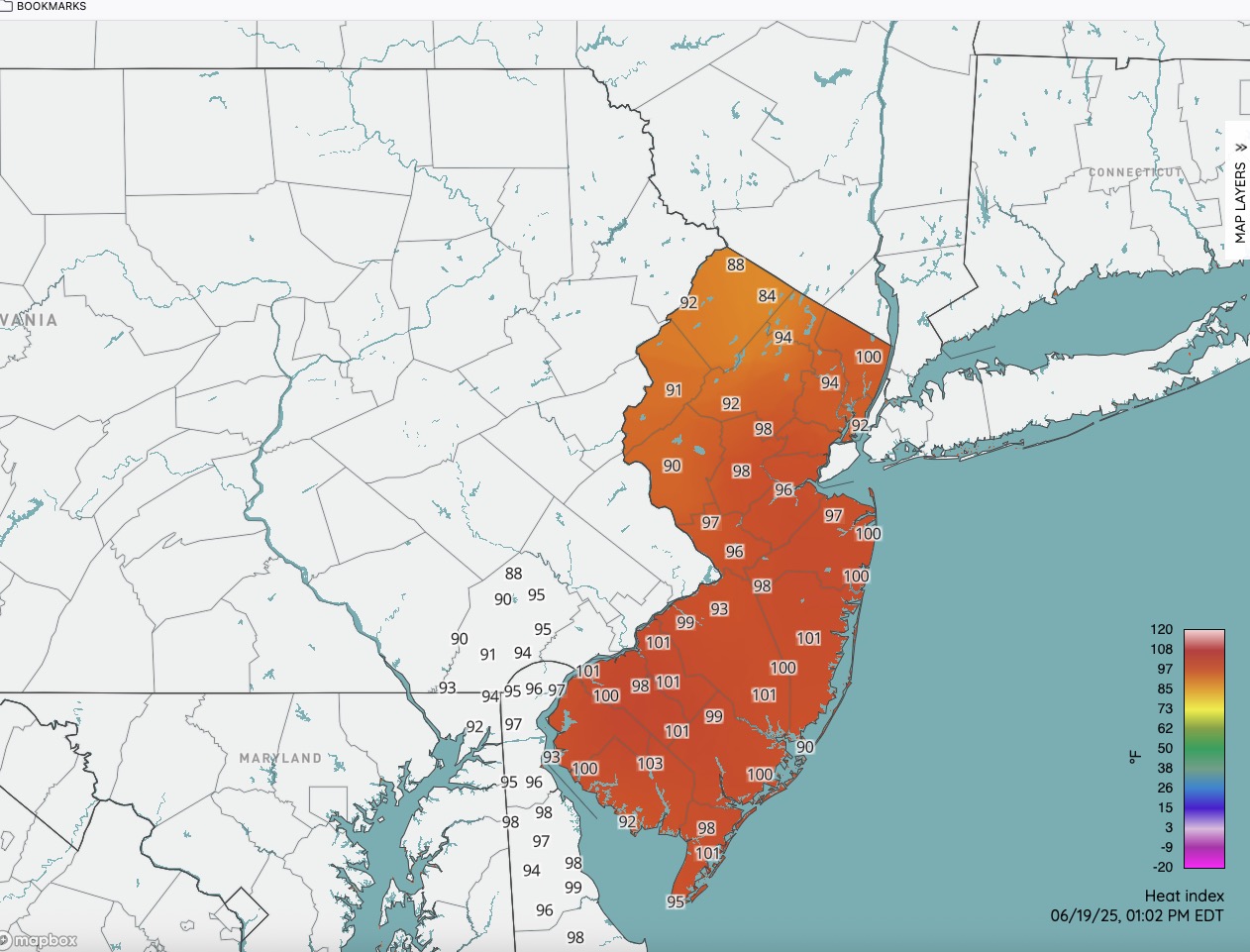
Latest HI numbers. We have cracked 100 in spots.

-
63, cloudy and a NW breeze at 1pm. Hard to believe whats lurking.
-
84/72 Feels great!
-
Nothing close to severe yet