All Activity
- Past hour
-
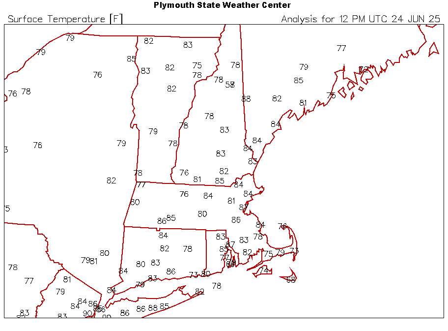
8AM: JFK: 90 EWR: 90 New Brnswck: 89 PHL: 88 ISP: 86 LGA: 86 TEB: 86 ACY: 86 NYC: 85 TTN: 83 BLM: ** nearest is 93
-
Yea, our climo this close to the ocean lags the solar calendar by a good month...which is why our cold peaks from about 1/20 to 2/1 and snow about a week after that.
-
 Dewpoint down to a crisp 72, lowest since Sunday morning for me
 -
High of 71 means you know the dewpoint won't be any higher than that lol Considering I spent most of the day yesterday with a dewpoint near 80 degrees it's going to feel downright dry!
-
 Getting ready to make history today!
 -

Central PA Summer 2025
Mount Joy Snowman replied to Voyager's topic in Upstate New York/Pennsylvania
Looks like our relief should come the way of a potent little backdoor cold front that sweeps through Thursday evening. -
No idea. I run the old cosole. It's very reliable, not to say the digi one isn't, but mabe shoot Davis an email and ask.
-
 Low of 75 here. Upton has a high of 71 both Thurs and Fri here-that will feel great.
 -
It was me that reported that my Davis Vantage Pro 2 reported a 81.8F dew at 2:45pm. I questioned that because it just intuitively seemed too high. Unless you're in a cornfield out west, you just don't see dews that high. Then I discovered something just now. I have 2 consoles reporting off my 1 station but the new LED console is showing a dew 2F higher than my older Davis console in the other part of the house. So I was watching the new LED console. Why would 2 consoles report different dews off of the same station. All other parameters seem correct? Any ideas? In any event, I'm going to go with the old console. In that case, my max dew would have been 79.8F
-
Transcended the point low by 1C - 24C/76F. Tues I was peg to be 26C high, every check it's increasing: went to 29C, now 30C. I'm soaring the last hour as I'm not far from 30C now! The last 3 night lows have been 25C (more like 26C, 80% of that overnight), 23C, and 24C. WUN nailed yesterday's details with exact high/low/full sun/RH, etc. from a forecast 4 days before on Fri. I noticed Toronto at 9:30 last night was still a insane 33C/90F Humidex 43C/110F.
-
86/77 in Arlington. Dog is already refusing to finish a full walk.
-
 I was outside of ISP about 30 minutes ago and it was already 86, it was actually cooler on the north shore, my PWS was still in the upper 70’s at that time. Normally the opposite.
 -
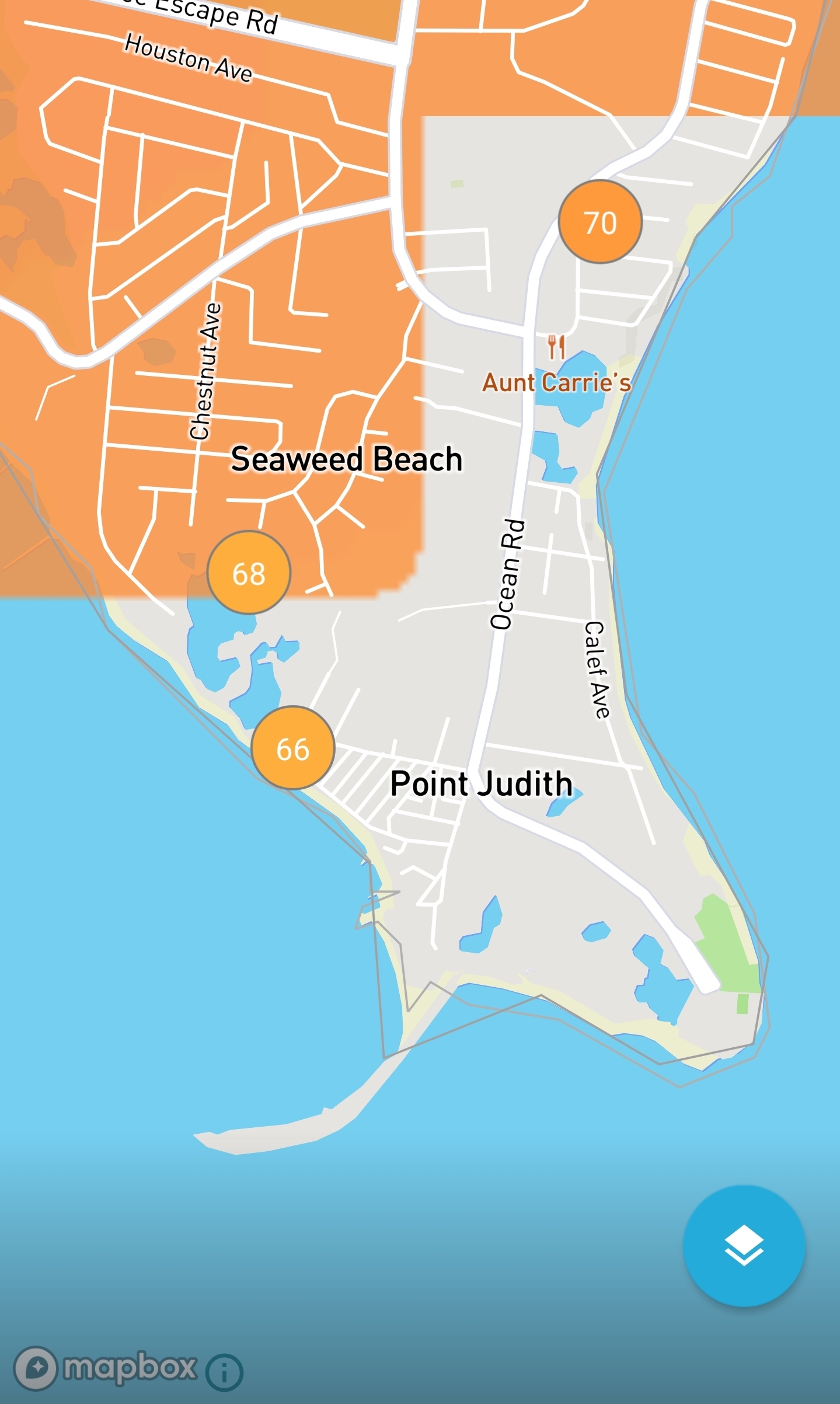
Seaweed Beach sounds great
-
HIt 99.7ºF here in Lowell yesterday. Can't remember if I've ever recorded 100. My overnight low was 77.5. Today's forcast high is 103.
-
I saw Christmas stuff going out at Hobby Lobby this weekend.
-
My sister's at her house on Pt Judith this week and said it was cold on her morning run. Haha. Looks like the high was only 78-79 yesterday on a few wunderground sites there.

-
Currently upper 80s in northern Queens and lower 90s in southern Queens
-
Cooled off fairly well last night; 65.7 goes in the books. While you are cooking today to a solid medium/medium-well, realize that Christmas Eve future is now closer than Christmas Eve past.
-
 Up to 85/74 already in sw suffolk
 -
what a terrific stretch of posts.
-
IZG 88F at 8a
-
EWR: 97 (1966)NYC: 96 (1888)LGA: 96 (2013)JFK: 97 (2010) Wild how hot EWR and JFK and LGA already were in 1966 and 2010 and 2013 around this time and it only got hotter in July. Wow, did this plane on a road near here? 1975: An Eastern Airlines Boeing 727 crashed at JFK airport in New York City. 113 of the 124 people on board the aircraft died. Researcher Theodore Fujita studied the incident and discovered that the crash was caused by a microburst. His research lead to improved air safety. The tower never experienced the microburst, which was held back by a seabreeze front. The plane crashed 2,400 feet short of the runway. (Ref. Wilson Wx. History)
-
wondering if this is at last a synergistic heat today -


.thumb.JPG.418e8a9a2902ae687ec35ff4bc0e038e.JPG)


