All Activity
- Past hour
-
Sad but true. You have kicked my butt as well.
-
How did I not know you were in Aruba?
-
Thanks. Getting more snow than @mappythe last two years has revitalized me
-
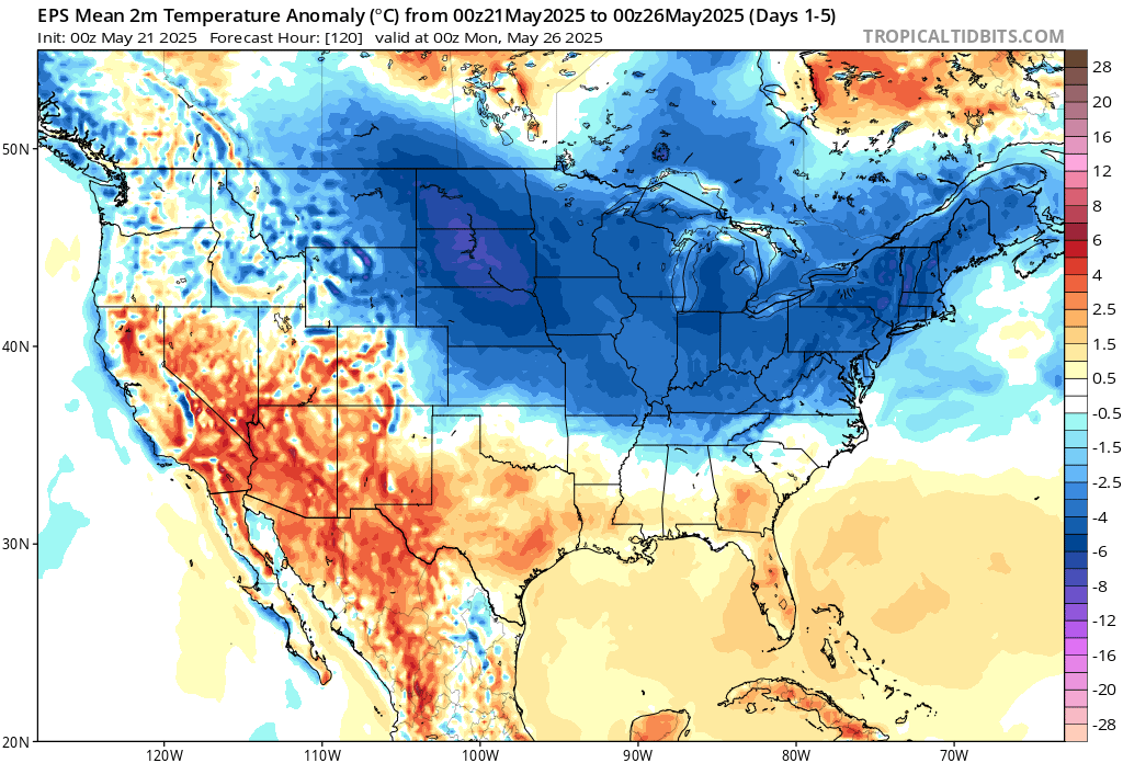
A cool March (i mean May) 21

-
Rain has begun. Timing again with rain looks to salvage the weekend, albeit it'll be very cool Saturday. A week ago the timing was more Thu- Sat and at one point looked to be the 3 day weekend.
-
Just got back from TNCA last evening. What a disaster this is.
-
Yeah it was nice to see the sun for a few seconds… just to reassure it’s still there.
-
Happy Birthday @H2O. You look damn good for 97.
-
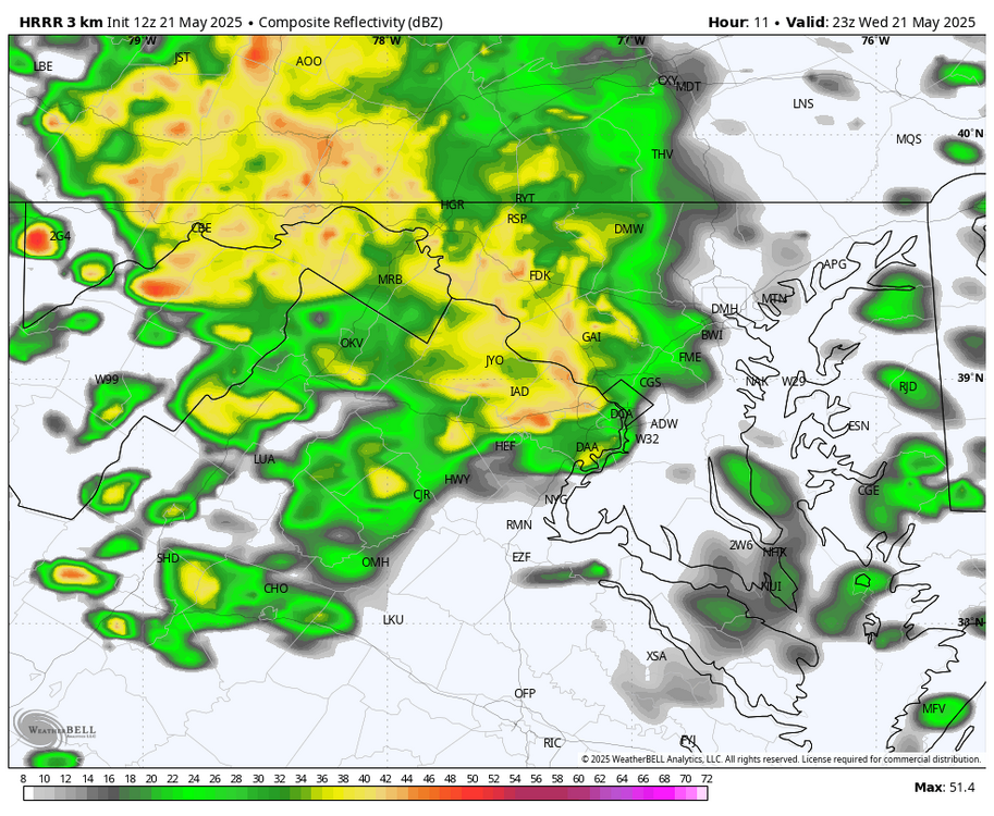
WB 12Z HRRR does bring in another round of heavier showers east of the mountains after 6pm.
-
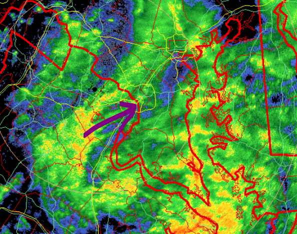
I saw a 10 second splash ... but yeah, it's hard to imagine even that much happening given this, https://weather.cod.edu/satrad/?parms=subregional-New_England-02-24-0-100-1&checked=map&colorbar=undefined ...which, that's pretty interesting to see that massive retrograde flow from the NE like that directly opposing that vortex-related flow arriving from the OV. Obviously the one from the west will ultimately win... but the battle will require the depths of misery
-
I'd say that after a 12 pack too.
-
12-18” with lollis to 24” and blizzard conditions at times.
-
thicc weekend is fine
-

2025-2026 ENSO
40/70 Benchmark replied to 40/70 Benchmark's topic in Weather Forecasting and Discussion
Keep in mind when I say "weak El Nino", that is a broad, general classification of the protptypical weak El Nino paradigm....once we actually get into the season, I will dig in more...obviously if we still have a Pacific cold phase/-RONI, then it probably wouldn't work. I incorporate all of that later in the fall. Yea, 2018-2019 was a tough one...I went big that season, but the early Jan SSW (focused on other side of globe) just served to lock the residual MC forcing from prior cool ENSO into place. This was also evident by the very paltry mid season MEI. El Nino wasn't running the show. -
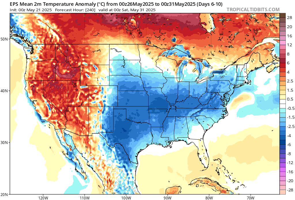
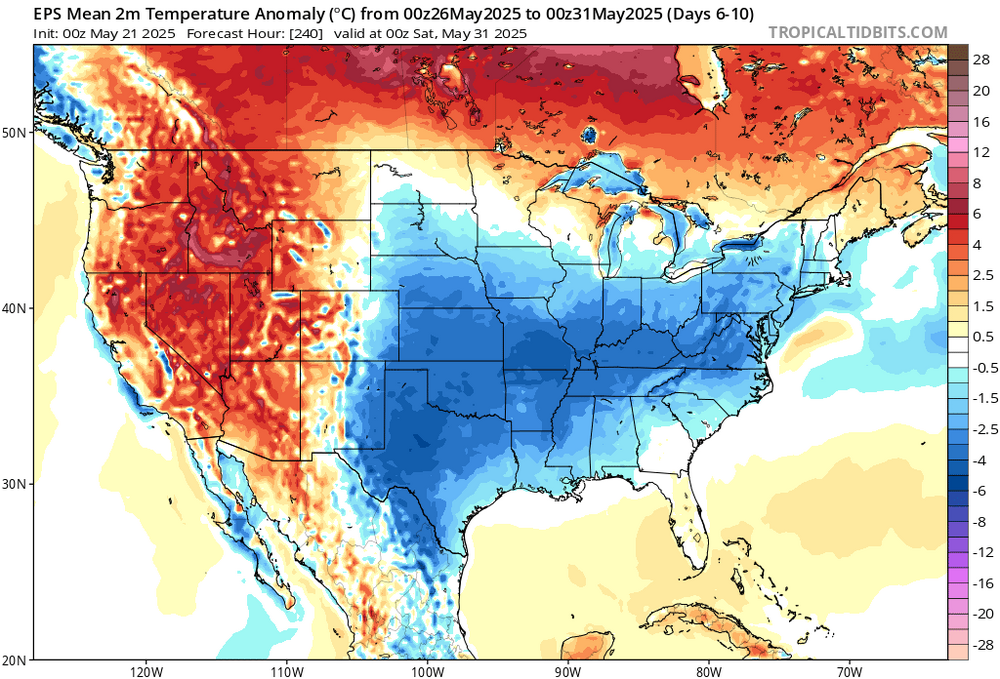
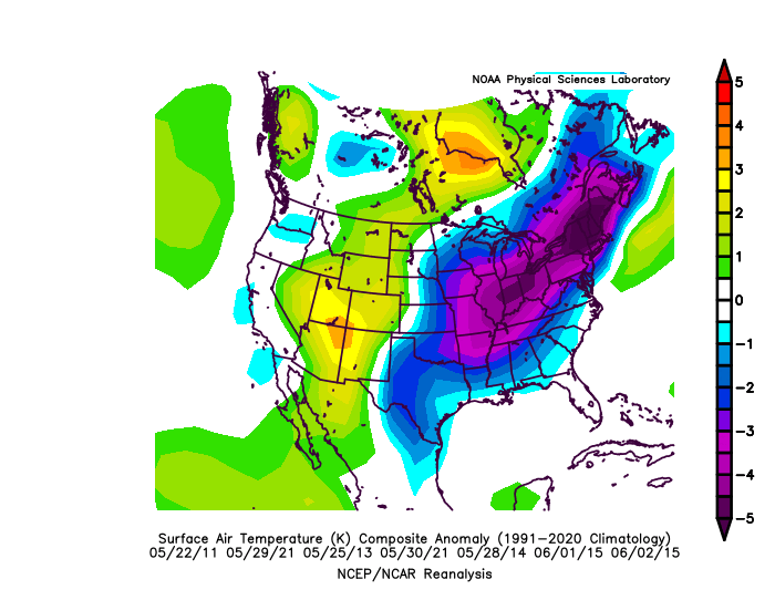
This end of May cool down has become a repeating feature over the last 10-15 years.

-
Speaking of gardens, everything is starting sooo slow. I dunno, maybe I'm just impatient but... I want fresh veggies!
-
Yeah, in the old days I would have agreed with you. But after we saw how the WPAC completely overpowered that weak El Niño in 2018 -2019, I have my doubts that a weak El Niño could work with this Pacific SST configuration. At least January 2019 was nice for the cold fans in the Midwest with the record cold near Chicago. But DJF was a real dud for snowfall around NYC with the La Niña background pattern and nearly no snowfall over those 3 months. Plus the weak modoki El Niño signature in 2019-2020 that was overshadowed by the record IOD supercharging the SPV. But at least we got some El Niño backloading with the record May snows. Unfortunately, we needed that storm track much earlier in the spring in order to really produce.
-
Seems like NWS knocked down rainfall. I hope that stays. But NWS also says there could still be heavy rain that could cause small stream flooding. I don't need that heavy rain. And I hope rainfall only totals around an inch or less. I don't need water setting in my garden again.
-
When a typo isn’t really a typo
-
Got a project ongoing in Carroll County, so the drier the weather this week the better.
-
Most of this is between Today and Sat AM it does has 0/10 - 0.15 for Tue/Wed next week
-
It was. The dramatic shift reveals the limits of the guidance beyond 10-14 days. Dramatic changes can and do occur. This time around, at least for the NYC area, the AI estimate will blow the modeling out of the water.
-
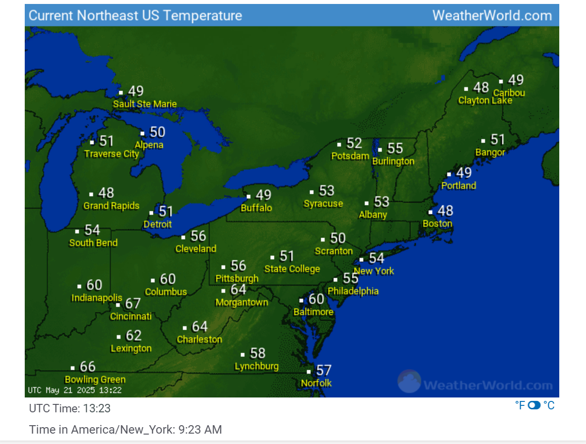
Cool period EWR: 5/19: 73 / 52 (-1) 5/20: 71/50 (-3) NYC: 5/19: 69 /51 (-4) 5/20: 67 / 49 (-6) LGA: 5/19: 70 / 52 (-4) 5/20: 68 / 50 (-6) JFK: 5/19: 74 / 53 (+3) 5/20: 76 / 50 (+1)
-
Mount Holly seems to to think later today and tonight for the Eastern and Southern areas based on forcing and other factors. We shall see. Looking at radar trends seems for my area two time periods to watch, in a few hours for the area of rainfall moving in from the West and then tonight as stated by the AFD. As the new surface low consolidates and moves north to off the New Jersey coast later tonight, the forcing for ascent should increase for a time again and this may be tied to a zone of 850 mb frontogenetic forcing to the north and west of the surface low. Depending on the strength and placement of this, a zone of heavier rain is possible. This should also result in an increase in the rain from west to east across much of the area this evening. An easterly low-level jet migrates northward across our area, especially tonight into Thursday morning, which could add to the ascent across parts of the region. Some of the rain will be heavier at times, which is when some localized urban flooding cannot be ruled out. Total rainfall amounts are forecast to be 1.0-1.5 inches across the region through the day Thursday. Some elevated instability could occur for a time especially this evening mostly south and east of Philadelphia, although it is less certain if it would be enough to result in some lightning/thunder.
-
Spotty light showers in inner moco and PGC this am. looks like a slightly brighter final band may come thru? IDK how far north though.