All Activity
- Past hour
-

Central PA Winter 25/26 Discussion and Obs
Jns2183 replied to MAG5035's topic in Upstate New York/Pennsylvania
I think the issue is there are not many analogs for this setup. It's exciting because it's rare. It also makes uncertainty go sky high. Throw in it being a big travel day and Im starting to feel bad for these guys. Sent from my SM-S731U using Tapatalk -

2025-2026 ENSO
Daniel Boone replied to 40/70 Benchmark's topic in Weather Forecasting and Discussion
Good work man ! -

December 2025 regional war/obs/disco thread
Sey-Mour Snow replied to Torch Tiger's topic in New England
If you want sleet. It crushes nyc metro even gets 3-6” well into New England .. thought it was a great move by gfs stopping that south trend. -
We always get the wrong trend. Can’t even get precip
-
Riveting string of storms...Im sure once we get one that has some actual precip with it, it will cut through the lakes and drive the temps up too, definitely feels like the twilight zone, more like groundhog day
-

Central PA Winter 25/26 Discussion and Obs
pasnownut replied to MAG5035's topic in Upstate New York/Pennsylvania
While it is trending better (like 0z GFS), I think they too are a little perplexed at the evolution. It's really an outside curveball IMO, but hey contact is contact when youre swingin at anything that'll get ya snow. -
That’s the feeling I’ve been getting too. We obviously haven’t had the accumulation the mountains have but it’s seems to snow at any opportunity.
-
Cmc
-

December 2025 regional war/obs/disco thread
TauntonBlizzard2013 replied to Torch Tiger's topic in New England
Canadian significantly weaker and more suppressed than 12z -

White Christmas Miracle? December 23-24th
codfishsnowman replied to Baroclinic Zone's topic in New England
I was thinking a White Christmas was on really thin ice down here even with an inch or two ...it gets pretty mild Wednesday afternoon and there's no icy mix to solidify things. Still some mood flakes a couple days before Christmas and having it not be bitterly cold isn't the worst thing. -
Central PA Winter 25/26 Discussion and Obs
pasnownut replied to MAG5035's topic in Upstate New York/Pennsylvania
hes 1 county (and about 20 miles) east of me. Your 230 miles west. Furthermore hes no troll like you. He offers tons more than you, and his reports are rather similar to much of the LSV. Try all you want, but you blew it in here a long long time ago. We've had this conversation before as well. You wont win anyone over in here. The only one you amuse is you and your climate pal that you call in for support . Take the hint and stop muckin up our forum. -
We used to get these all the time in the 90s and early 2000s.
-
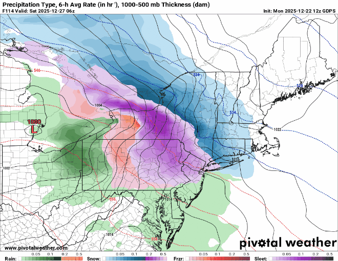
 The 0z GFS still looks pretty solid. General mean of 0.1 - 0.3" liquid across all guidance. The radar is a little ragged but slowly building and snow isn't expected until just before dawn. Do we get cranking or does it fizzle? Nowcast in the early morning... 0.25 liquid over 8 hours is a fairly respectable average intensity if it happens.
 -
that's a nice run
-
pretty snowy for NYC though. If it wasn’t a holiday it might be a good week to go
-
Gfs is what you want to see 5 days out. We want this thing to have wiggle room to come north. This is a weird storm though. Like some kind of atomic clipper.
-
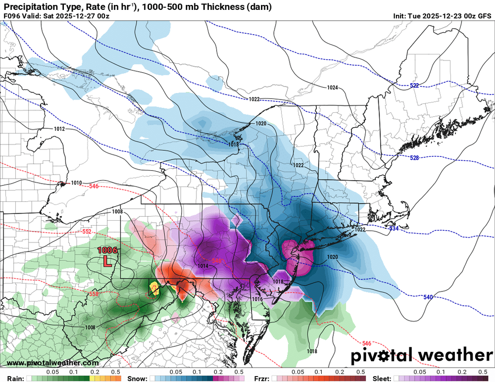
Terrible run . No precip
-
Damn.
-
Not much margin for error since the cold side precipitation is unlikely to be extremely widespread. But run to run changes are decreasing in magnitude and most mid-range guidance appears to be converging on at least some wintry precip. locally. Obviously a fringing or ZR to rain are still possible but the envelope appears to be shrinking.
-
Gfs north
-
December 2025 regional war/obs/disco thread
TauntonBlizzard2013 replied to Torch Tiger's topic in New England
Congrats Philly on the gfs -
Wintry 5 days on the GFS! Might even squeeze in some flakes or ZR on Xmas day in the weak wave in between the Tue and Fri night events.
-
Did get little warmer than last run though.
-
Heavy precip from Philly to NYC
-
.thumb.png.4150b06c63a21f61052e47a612bf1818.png)
White Christmas Miracle? December 23-24th
HIPPYVALLEY replied to Baroclinic Zone's topic in New England
Definitely some dry air to fight through. Currently 23/16 at mi casa. Counting on that initial burst to drop an inch here.


