All Activity
- Past hour
-
Yes, that was a big part of HM’s disco on this topic (-QBO/-ENSO resulting in a flat Aleutian ridge and +QBO/-ENSO resulting in a poleward Aleutian high). He actually went into a very detailed disco with a bunch of images in his blog. Shame I can’t find it anymore to share on here
-
I did some digging and turns out it’s something called “rain”. It’s a relatively common weather phenomenon across some parts of the world. Exciting to see it so close by!
-
Getting the first glimmer of leaf change in the usual low lying, wetland area.
-
There are a lot of green, yellow and orange returns showing up on radar in southeast Wisconsin. I’ll investigate what it could be.
-

September 2025 OBS-Discussion centered NYC subforum
bluewave replied to wdrag's topic in New York City Metro
MPO made it down to 41° at the end of August which was the coldest since 2000. But not really that cold prior to 2000. The drier conditions allowed them to make it to the 11th coldest reading for August. The warmth back in June was more impressive. It was their first June 93° maximum temperature. Time Series Summary for Mount Pocono Area, PA (ThreadEx) - Month of Aug top 10 lowest temperatures Click column heading to sort ascending, click again to sort descending. 1 1986 31 0 2 1965 32 0 - 1907 32 0 3 1987 33 4 - 1941 33 0 - 1940 33 0 4 1982 34 0 - 1976 34 0 - 1942 34 0 - 1923 34 0 - 1910 34 0 - 1908 34 0 - 1904 34 0 5 1979 35 0 - 1921 35 0 - 1916 35 0 6 1972 36 0 - 1971 36 0 - 1968 36 0 - 1934 36 0 - 1927 36 0 - 1912 36 0 - 1911 36 0 7 1992 37 4 - 1989 37 6 - 1988 37 5 - 1963 37 0 - 1947 37 0 - 1946 37 0 - 1922 37 0 - 1915 37 0 - 1909 37 0 - 1905 37 0 - 1903 37 0 8 1981 38 0 - 1977 38 0 - 1930 38 0 - 1924 38 0 - 1919 38 0 9 1969 39 0 - 1964 39 0 - 1949 39 0 - 1944 39 0 - 1935 39 0 - 1906 39 0 - 1902 39 0 10 2000 40 0 - 1974 40 0 - 1966 40 0 - 1962 40 0 - 1952 40 0 - 1950 40 0 - 1936 40 0 - 1929 40 0 - 1917 40 0 11 2025 41 0 - 1984 41 0 - 1983 41 0 - 1958 41 1 - 1957 41 0 - 1954 41 2 Time Series Summary for Mount Pocono Area, PA (ThreadEx) - Month of Jun warmest maximum temperatures Click column heading to sort ascending, click again to sort descending. 1 2025 93 0 2 1952 92 0 - 1933 92 0 - 1914 92 0 3 2011 91 0 - 1911 91 0 4 2012 90 0 - 1964 90 0 - 1957 90 3 - 1956 90 0 - 1953 90 0 - 1908 90 0 5 2021 89 0 - 2008 89 0 - 1944 89 0 - 1943 89 0 - 1934 89 0 - 1925 89 0 6 2024 88 0 - 2023 88 0 -
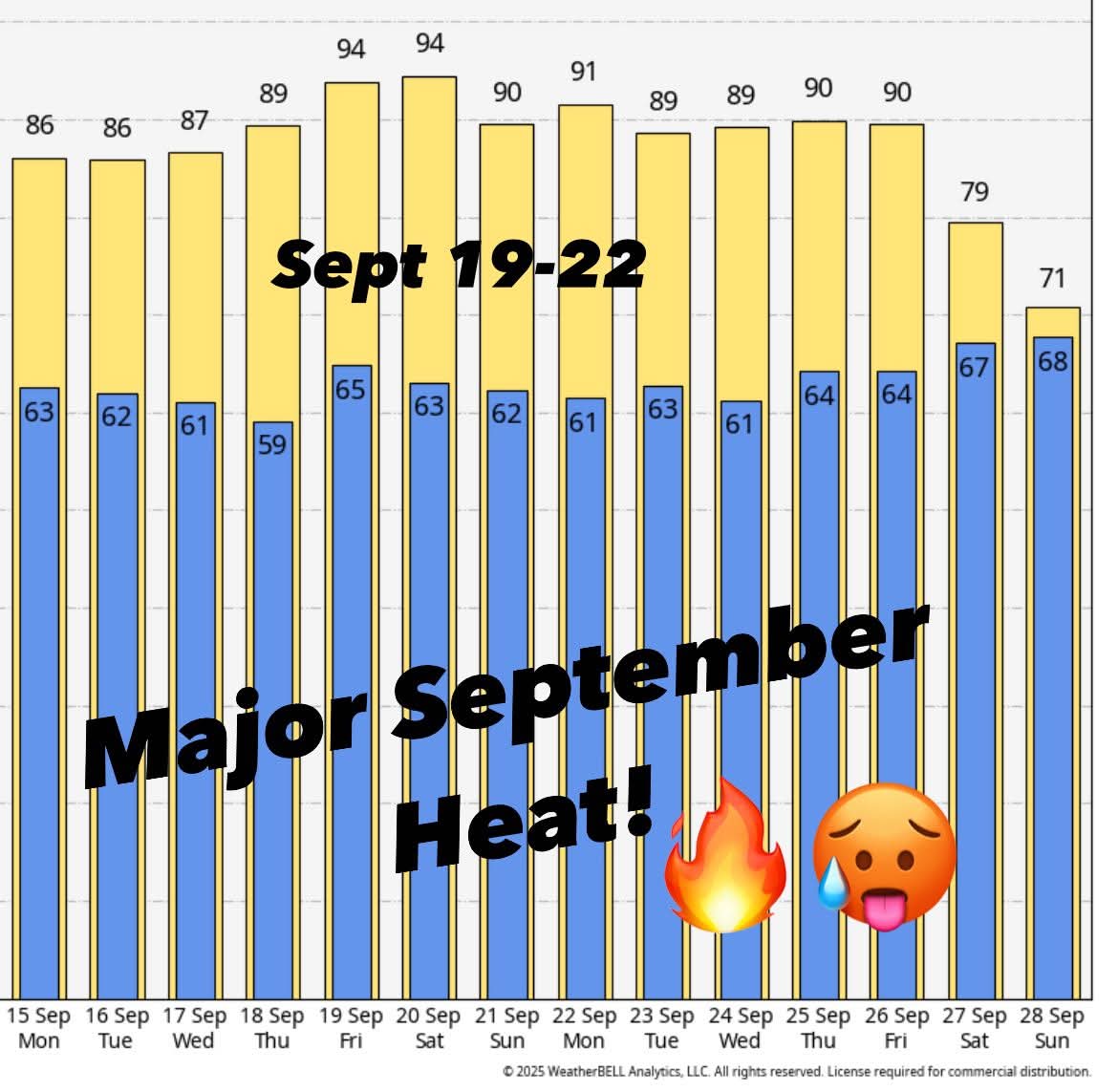
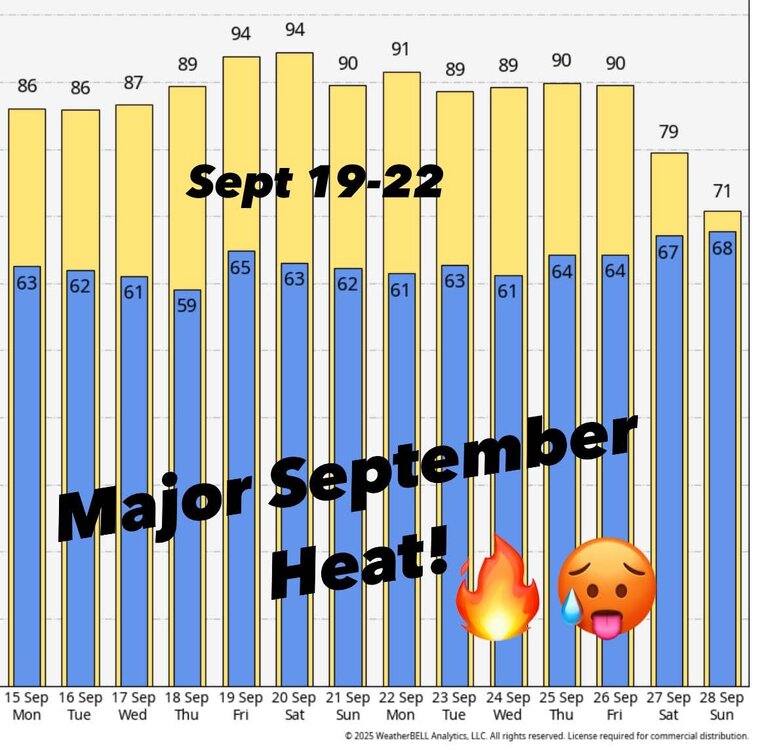
What a week coming up.. Next week looks dry and unseasonably warm with highs in the 80s inland! Summer is not over yet! Keep the pools open and the boats in the water.
.jpg.8f99922b8a0dc1b5f14ce8f6e0260c04.jpg)
- Today
-
.thumb.jpg.6a4895b2a43f87359e4e7d04a6fa0d14.jpg)
Central PA Banter (Banter Less?) Thread
Yardstickgozinya replied to Itstrainingtime's topic in Upstate New York/Pennsylvania
https://youtu.be/azE7nqqQMmo?si=etqrdvu28PyzRfE3 -
Lol
-
haven't mowed my lawn in probably two weeks - it would be mostly running over walnuts anyway. seeing lots of trees starting to pop with color, especially near the lakes on my way to work in the morning. patchy fog has been the most exciting part of the past five days otherwise.
-
Upstate heatwave
-
We’ll get it briefly in early nov and probably early April as a few mangled, fat flakes and as usual, everything in between will be variations of chilly and warm rain, mixed in with occasional periods of 65 degree mist and fog. Of course, northern New England is a whole different realm so you know they’ll have their many moments of glory.
-
Ha...sentence about proofreading wasn't proofread
-

2025-2026 ENSO
Stormchaserchuck1 replied to 40/70 Benchmark's topic in Weather Forecasting and Discussion
The top 5 analog years are all in the last 5 years. How have you done in the last 5 years? The next two weeks should have a trough in the NE N. Pacific. If people are freaking out about warm SSTAs there, there really shouldn't be a strong, persistent trough developing but the atmosphere comes first and SSTs 2nd. In 2 weeks the warm water in the Gulf of Alaska should cool.. -

2025-2026 ENSO
Daniel Boone replied to 40/70 Benchmark's topic in Weather Forecasting and Discussion
Lol. I didn't notice that. Should or proof read. -
I’ve had less than 1” rain since June 20.
-
Especially since Capital Region Water is gonna start drawing out of the river soon. They will shut down Dehart supply to fix pipes I think for about 2 weeks.
-
I dunno,dont shoot the messenger,but it seems to be more related to the ENSO,IN 1980 our subforum into NC and the east coast would be saying bring it on,maybe a coincidence,i have know clue,planetary waves can take weeks if not months to have effects in NA, but both of these years i stated above seem to be more of developing ELNino,not NINA with a SWE in the SP https://www.weather.gov/mhx/Mar011980EventReview
-
I was going to say...see you around Thanksgiving. Regardless, have an amazing time!
-
Yes it does.
-
Yikes days lol 5 in Copenhagen, 5 in Stockholm
-

Occasional Thoughts on Climate Change
LibertyBell replied to donsutherland1's topic in Climate Change
the only real dip we had was in 2020 during the pandemic, when not coincidentally, air and water pollution also got much less. -
Occasional Thoughts on Climate Change
LibertyBell replied to donsutherland1's topic in Climate Change
whats causing the increase in consumption Don? something that no one likes to talk about but is a fundamental problem with society today is population growth. I know it's not as much of a problem in Westernized nations but it's most definitely a problem in the Developing world. The UN estimates the population will stabilize around 11 billion in 2080 and they'd better be right, one of the major reasons for all this usage of energy and resources is the earth simply cannot support a human population more than about 11 billion-- it's the carrying capacity of humans on the planet. -
averages dropping quick now
-

Central PA Summer 2025
TheClimateChanger replied to Voyager's topic in Upstate New York/Pennsylvania
Wow, where are you heading? Iceland? -
I wish we had this weather April through October.. its been perfect!