All Activity
- Past hour
-
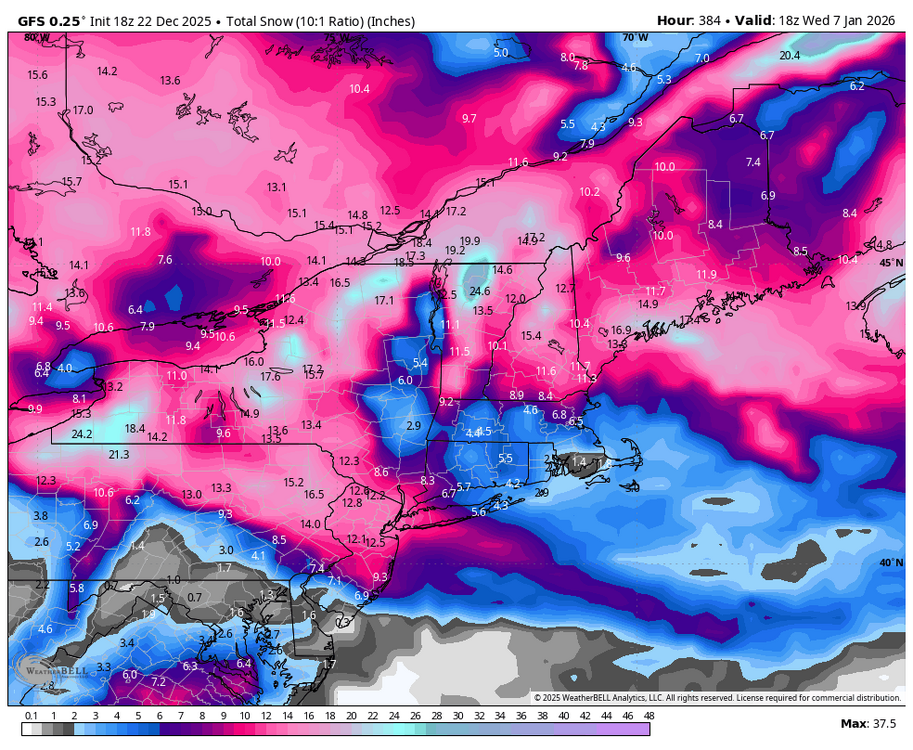
Moisture slamming into a cold dome could yield a lot of snow but agree that it's very unlikely to be this far south unless blocking is very strong
-
.thumb.png.4150b06c63a21f61052e47a612bf1818.png)
White Christmas Miracle? December 23-24th
HIPPYVALLEY replied to Baroclinic Zone's topic in New England
That would be zero accumulation for much of MA. .05” qpf spread over 8 hours. -

December 2025 regional war/obs/disco thread
WinterWolf replied to Torch Tiger's topic in New England
Well, you can see TBlizz starting to hint and show his hand already…he’s revving up for a tirade of negativity. This thing will waffle over the next few days…we gotta roll with it for a bit. As Will Said, anything from this is a bonus anyway. -

White Christmas Miracle? December 23-24th
weatherwiz replied to Baroclinic Zone's topic in New England
Hoping for 1.5” tomorrow and that will get me to about 7” for the season and only 93” away from 100”!!! -
Quit trying to excite Weather Will like that.
-
December 2025 Short/Medium Range Forecast Thread
Golf757075 replied to John1122's topic in Tennessee Valley
Carver, I think if the mjo gets active, it should allow the pacific to align for cold here for a few weeks, providing the mjo moves along imo -

White Christmas Miracle? December 23-24th
ORH_wxman replied to Baroclinic Zone's topic in New England
He’s so close to water which may be an issue for a time until winds go more N or NW. Light snow and 33-34 might struggle. -
Always been my thought process. But some still enjoy useless cold and 4 hours to get an inch events over 60s in the winter.
-

December 2025 regional war/obs/disco thread
powderfreak replied to Torch Tiger's topic in New England
That run was a clipper parade. Your new spot will continue to clean up with us in NNE if we get energy every couple days coming in from the NW and plenty of cold. The difference from your area to the eastern Adirondacks is pretty stark in these types of patterns. - Yesterday
-
That was a very cold run. Very few torches. 12/28 gets messy with ice/rain but not warm at all. That Atlantic blocking just dominates for 10 days.
-

White Christmas Miracle? December 23-24th
Damage In Tolland replied to Baroclinic Zone's topic in New England
It’s had 1-3” for like 8 runs in a row for most of SNE. Good luck to you and Scooter out east . He thinks he’s getting rain -
Parts of the central Carolina we are all dead from crippling ice storm
-

December 2025 regional war/obs/disco thread
Baroclinic Zone replied to Torch Tiger's topic in New England
Too soon for a New England thread. NY/PA in better spot right now. I’d like to see the ensm tighter up the spread better for New England. -
I think you'll do quite well too. Upslope looks a bit unblocked which should help drift your way on the backside.
-

December 2025 regional war/obs/disco thread
moneypitmike replied to Torch Tiger's topic in New England
I've got little interest in Friday--though I know many rightfully do. I am interested in Sunday though. -
The upper level looked way better than the surface storm
-
Maybe it’s the higher res or the euro ?
-
Bing Crosby, nuff said.
-

December 2025 regional war/obs/disco thread
WxWatcher007 replied to Torch Tiger's topic in New England
I won’t dare risk it despite being the leader in the clubhouse so far this season, but it’s time for a Boxing Day thread. -
I hope you’re right-hoping for an inch tomorrow so that would get me to 9” for the month, then this could add quite a bit if it goes well. These usually trend north at the end, we’ll need confluence and blocking to keep it south. I’d feel a little better about this one for Boston but we’ll see.
-

White Christmas Miracle? December 23-24th
Baroclinic Zone replied to Baroclinic Zone's topic in New England
Y/w -

White Christmas Miracle? December 23-24th
ORH_wxman replied to Baroclinic Zone's topic in New England
Euro a couple runs in a row trying to show a little enhancement in E MA tomorrow evening…maybe someone can crack 3” if that happened. Prob in the 128 belt to maybe 495..esp N of pike. Then there’s still the OES sig as the IVT rotates S and veers the winds back N for a time which puts the Cape into a decent spot. -
Just a warning criteria snow (4"+) thats not much really.
-
Noticed this a few times this year, think it’s some glitch, error, or something. Look at this precip output, ridiculous. .


