All Activity
- Past hour
-

2025-2026 Fall/Winter Mountain Thread
SEwakenosnowforu replied to Buckethead's topic in Southeastern States
What are we looking at this weekend for two locations? Blowing rock Beeche mountain? What is the best day for the two? Saturday and Sunday. -

January 2026 Short/Medium Range Thread
Holston_River_Rambler replied to John1122's topic in Tennessee Valley
18z GFS trending to back the flow for Saturday night too: -

January 2026 Medium/Long Range Discussion
soadforecasterx replied to snowfan's topic in Mid Atlantic
Really like the trends on icon and gfs. Always felt the second storm had the better chance -
I remember a similar map someone posted in Early December. December ended up just fine, through most of the forum.
-
Wilmington now on notice!
-
18z GFS was a step in the right direction, more digging and separation, looked really close to being a lot more for Sunday. Maybe ens will start to pick up.
-
Then you don’t like winter weather .Come back in May
-
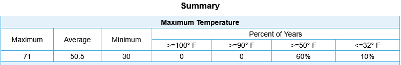
I was about to contradict you, but nope, you're right. This is the stats for every January 13th in the last 30 years at DCA. 60% of all Jan 13th's (since 1996) have been at or above 50.
-
WB is behind. Its around 15z Tues that is of interest.
-
Seeing a trend in the last 3-4 gfs runs. Might steal a little something there?
-

January 2026 regional war/obs/disco thread
ORH_wxman replied to Baroclinic Zone's topic in New England
18z GFS trying to make this interesting on 1/18-19....not gonna quite get there but that was a pretty good sharpening of the trough compared to previous runs. -
January 2026 Short/Medium Range Thread
Holston_River_Rambler replied to John1122's topic in Tennessee Valley
I pulled some soundings off the HRRR for the Bays Mt band. I may pull some more if it keeps showing it. I'm not good at reading soundings other than the bare minimum of hodographs and thermal/ moisture profiles/ DGZ, so I was wondering if there is any other info in these soundings that might add something to how we understand the band. Just for comparison here is a sounding just SW in northern Greene county: I'll be heading up to Kingsport Thursday AM, so hopefully I can do some more investigating. -

Winter 2025-26 Short Range Discussion
HillsdaleMIWeather replied to SchaumburgStormer's topic in Lakes/Ohio Valley

-
Although its the trailing energy the produces the lift and precip on previous runs, so maybe
-
Yeah, too far east. Just some interesting changes
-
Well vs 12, moisture on the coast now wehre there was none. But it's too far east
-

Pittsburgh/Western PA WINTER ‘25/‘26
colonel717 replied to Burghblizz's topic in Upstate New York/Pennsylvania
Tomorrow evening around 7pm looks to be the heaviest snow 3-4 per GFS -
Damn WB so slow. But I don't like it at hour 102. Positively tilted.
-
Oh you know it. A week of 40's and rain coming up.
-
Diffrent look upstairs on the GFS so far. Prob won't amount to much tho
-
Its frenetic as fuck. Fun! GFS has been most persistent, although all over the place from run to run.
-
AI GFS is closer with Sunday and looks much colder. But after what the GFS did with our snow/rain showers on Thursday and hyped it into a big snowstorm, it’s hard to believe
-
Re: Weds…18z GFS w a lee side low again on this run. Slight uptick in intensity for E TN folks and Plateau.
-
Cmc has it at 12z
-
The Cape storm is centered on the the 19th-20th. Anything else is not mine lol. That's the window I said I liked for a winter storm based on the ens h5 look several days ago now. It has changed some ofc. But still.