All Activity
- Past hour
-

July 2025 Discussion-OBS - seasonable summer variability
SACRUS replied to wdrag's topic in New York City Metro
83 / 71 still in/out sun -
July 2025 Discussion-OBS - seasonable summer variability
SACRUS replied to wdrag's topic in New York City Metro
Records: Highs: EWR: 99 (2011) NYC: 99 (1966) LGA: 98 (1966) JFK: 98 (2011) New Brnswck: 98 (1988) Lows: EWR: 52 (1945) NYC: 57 (1926) LGA: 59 (1940) JFK: 58 (1973) New Brnswck: 48 (1945) Historical: 1842: One of the most severe hurricanes in the history of the coastal Carolinas struck the Outer Banks of North Carolina on the evening of the 12th into the 13th. The entire village of Portsmouth was destroyed except for one building. The storm apparently passed inland near Norfolk, VA and caused massive flooding from Virginia into Pennsylvania. (Ref. Wilson Wx. History) 1936: The hottest three-day periods up to this time in United States history occurred beginning on this date as the average temperature was 88.5°; the second warmest such period occurred three days earlier. (Ref. Wilson Wx. History) 1951 - The Kaw River flood occurred. The month of June that year was the wettest of record for the state of Kansas, and during the four days preceding the flood much of eastern Kansas and western Missouri received more than ten inches of rain. Flooding in the Midwest claimed 41 lives, left 200 thousand persons homeless, and caused a billion dollars property damage. Kansas City was hardest hit. The central industrial district sustained 870 million dollars property damage. (The Kansas City Weather Alamnac) 1974: Philmont Scout Ranch, Colfax County, N. Mex.-- Lightning struck a group of scouts and leaders who had gathered beneath a nylon dining canopy to avoid heavy rain; killed one, injured six. (Ref. Lightning-The Underrated Killer.pdf) 1975: A nearly stationary front north to south over Pennsylvania caused rain and thunderstorms over the region for 3 days beginning on this date. Amounts of two inches plus in 24 hours and 4 inches plus for the 3 days were common. In Pennsylvania, Perkasie reported 7 inches, Lansdale: 5.11 inches, West Chester: 6.94 inches through the 13th; and Schwenksville reported 6 inches in 30 hours. (Ref. Wilson Wx. History) 1979: First 90° day of year was very late in the year. This was the latest 90°F day ever recorded in Washington, DC. (Ref. Washington Weather Records - KDCA) 1980 - Lightning struck a large broiler house in Branford, FL, and the ensuing fire broiled 11,000 nearly ready broilers. Firemen were able to save a few thousand chickens, however. (The Weather Channel) 1987 - Cool air invaded the High Plains Region. Eight cities reported record low temperatures for the date, including Sheridan, WY, with a reading of 37 degrees. Thunderstorms developing along the cold front in the central U.S. produced 6.5 inches of rain at Fort Dodge, IA, and 2.5 inches in one hour at St. Joseph MO. (The National Weather Summary) 1988 - Evening thunderstorms produced severe weather over the Dakotas, including baseball size hail at Aberdeen, SD, and softball size hail near Fullerton, ND. Thunderstorms produced heavy rain in Arkansas and northeastern Texas, with 6.59 inches reported at Mesquite, TX, in just an hour and fifteen minutes. Garland, TX, reported water up to the tops of cars following a torrential downpour. (The National Weather Summary) (Storm Data) 1989 - Early morning thunderstorms over eastern Kansas deluged McFarland with more than six inches of rain. Afternoon thunderstorms in Wyoming produced up to eighteen inches of dime size hail near Rock Springs, along with torrential rains, and a three foot high wall of mud and water swept into the town causing more than 1.5 million dollars damage. Evening thunderstorms produced severe weather in Oklahoma and Arkansas, deluging Dardanelle, AR, with 3.50 inches of rain in less than twenty minutes. About seventy cows were killed when lightning struck a tree in Jones County, TX. (The National Weather Summary) (Storm Data) 1993: Thunderstorms dumped up to 4 inches of rain in 30 minutes in the Pierre and Ft. Pierre areas in South Dakota. As golf ball size hail also pounded the area the runoff from the heavy rains piled the hail into drifts five feet high. On the same day a severe thunderstorm dumped large hail and heavy rains in the Lantry area in Dewey County. The water which could not be absorbed by already saturated ground ran four to five feet deep through some buildings in town. (Ref. Wilson Wx. History) 1995: An intense heat wave affected much of the Midwest for a 4-day period beginning on this day. The worst effects of the heat were noted in the Chicago metropolitan area, where 583 people died from the heat. Temperatures across the region reached as high as 104 degrees, overnight lows on falling to the upper 70s to low 80s. Dew point temperatures in the upper 70s to low 80s created heat indexes peaking at 125 degrees. Electricity and water usage reached record levels, causing periodic outages. 1996: Hurricane Bertha makes landfall near Wrightsville Beach, NC with maximum winds of 105 mph, but the storm surge dealt the most devastation. The U.S. Virgin Islands, along with North Carolina, were declared federal disaster areas. Surveys indicate that Bertha damaged almost 2,500 homes on St. Thomas and St. John. For many, it was the second hit in the ten months since Hurricane Marilyn devastated the same area. The primary effects in North Carolina were to the coastal counties and included storm surge flooding and beach erosion, roof damage, piers washed away, fallen trees and damage to crops. Over 5,000 homes were damaged, mostly from storm surge. Storm total rainfall amounts ranged from 5 to 8 inches along a coastal strip from South Carolina to Maine. Overall, as many as 12 deaths resulted with 8 in the U.S. and territories. 1997: Lightning can hit the ground 15+ miles from the thunderstorm. Two golfers at a Tampa Florida course were hit by the first observed lightning bolt of a distant thunderstorm; it came from the storms cirrus anvil. The sun was shining at their location and one of the two men was killed. (Weather Guide Calendar with Phenomenal Weather Events 2007 Accord Publishing, USA) 1998: The temperature at the Dallas/Ft. Worth Airport in Texas rose to 100°. Dallas saw the temperature go to 100° or hotter on 56 days during the summer of 1998. There were 39 nights that the mercury never dropped below 80°. (Ref. Wilson Wx. History) 2004: Hail up to the size of softballs fell in and around Onaka, SD damaging vehicles, farm equipment, and homes. High winds along with hail up to the size of baseballs caused some structural, vehicle, crop, and tree damage in and around Astoria, SD and Toronto, SD. (Ref. Wilson Wx. History) 2005: July 12th to July 20th Reno, Nevada: A record string of days with temperatures above 101°F: nine straight days. (Ref. WxDoctor) 2011: High humidity levels and dew points were higher during the summer 2011 compared with 2010, resulting in unusually warm nighttime temperatures. A low temperature of 81 at Richmond on July 12th was the first ever daily low of 80 and above. A steady southwest wind overnight also contributed to this event. (Ref.NWS, Wakefield, Virginia - A New Record High Minimum Temperature) 2022: On the evening of July 12 between 8PM and 10 PM around 4.50 inches of rain fell in the Buchanan County, Virginia area. (Ref. Wilson Wx. History) -

July 2025 Discussion-OBS - seasonable summer variability
bluewave replied to wdrag's topic in New York City Metro
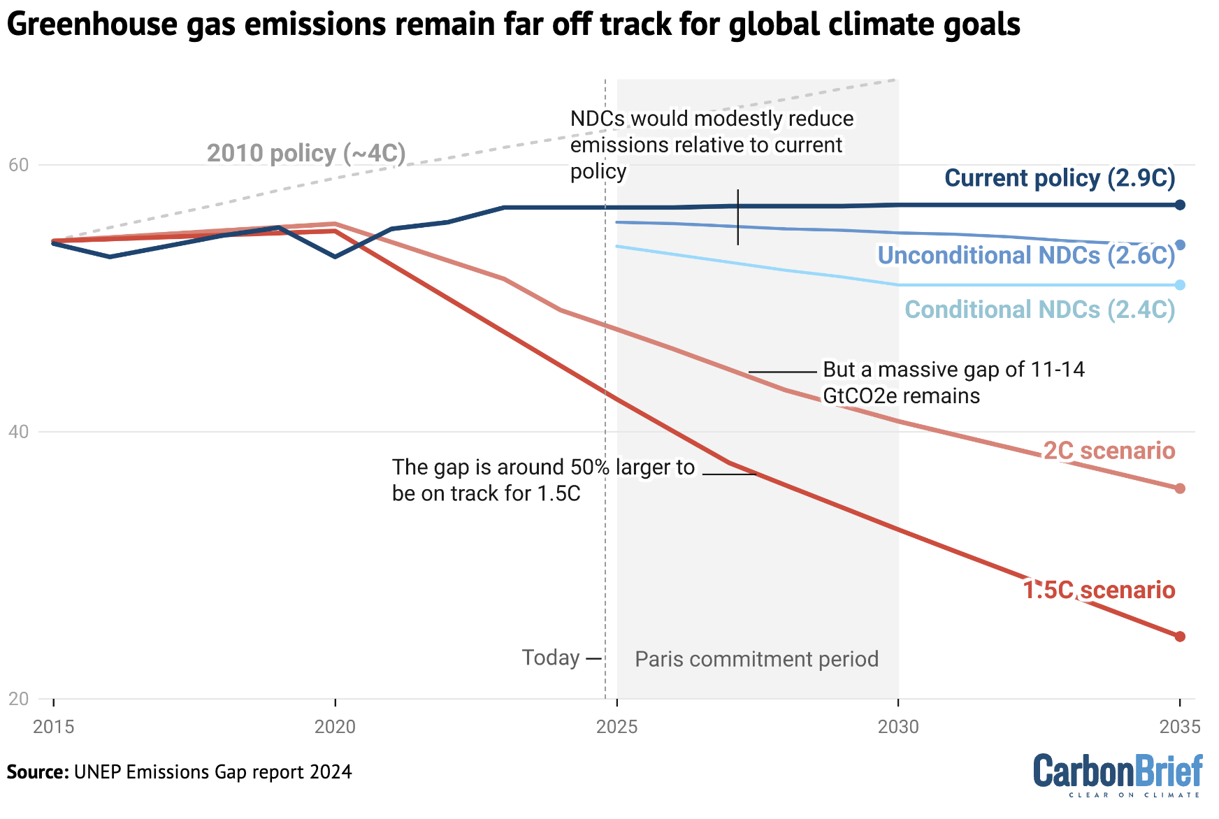
Some newer studies are backing off those older predictions. -

July 2025 Discussion-OBS - seasonable summer variability
Dark Star replied to wdrag's topic in New York City Metro
I volunteer you to get China on board... -
Showers moved thru this morning. Parade in TH today for our annual Heritage Days festival. Air quality alerts out for the Upper Midwest as heavier smoke works it's way in behind the front.
-

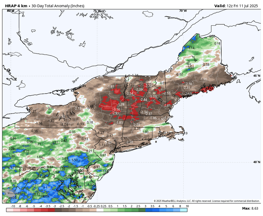
July 2025 Obs/Disco ... possible historic month for heat
powderfreak replied to Typhoon Tip's topic in New England
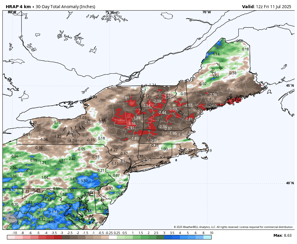
There’s no way that’s accurate in VT and upstate NY is there? I’m at like 7” since June 1. -

July 2025 Obs/Disco ... possible historic month for heat
Lava Rock replied to Typhoon Tip's topic in New England
Other then the late day sun, been pretty cloudy since Weds Boothbay arrival. Currently quite foggy on our way out to monhegan island. Sent from my SM-S921U using Tapatalk -

July 2025 Discussion-OBS - seasonable summer variability
steve392 replied to wdrag's topic in New York City Metro
Just uncomfortable out. -

July 2025 Obs/Disco ... possible historic month for heat
40/70 Benchmark replied to Typhoon Tip's topic in New England
It's usually time to draw the shades and hide in the AC if you hate dews from now until about first week or two of September.....this next two months are usually office, save for a rogue pleasant day or three- -

July 2025 Obs/Disco ... possible historic month for heat
RUNNAWAYICEBERG replied to Typhoon Tip's topic in New England
It would be wolfie’s lifetime achievement if he could be one of the cops there. -
July 2025 Discussion-OBS - seasonable summer variability
SACRUS replied to wdrag's topic in New York City Metro
82 / 71 partly cloudy - sun poking through. Warm/humid the next few days mostly 80s- hotter inland spots away from sea breeze may make it to 90 Scattered storms Sun late and more Monday. Hot/humid week ahead and overall hotter into the beyond. 7/12 - 7/14: Warm / humid storms rain focus in Monday 7/15 - 7/18 : Hotter / humid. 7/19 - Beyond : Hot / humid wetter overall -

July 2025 Discussion-OBS - seasonable summer variability
forkyfork replied to wdrag's topic in New York City Metro

- Today
-

July 2025 Obs/Disco ... possible historic month for heat
Sey-Mour Snow replied to Typhoon Tip's topic in New England
-
Boy it’s gross out
-
July 2025 Discussion-OBS - seasonable summer variability
forkyfork replied to wdrag's topic in New York City Metro
societal breakdown is the only way climate change will be stopped -

July 2025 Obs/Disco ... possible historic month for heat
CoastalWx replied to Typhoon Tip's topic in New England
Nice and sunny now -

July 2025 Obs/Disco ... possible historic month for heat
kdxken replied to Typhoon Tip's topic in New England
No sign of Stein in Connecticut.
-

July 2025 Discussion-OBS - seasonable summer variability
SnoSki14 replied to wdrag's topic in New York City Metro
What's truly mind-blowing is that in only 50 years temperatures have increased by that much whereas they've been mostly stable for 10s of 1000s of years prior to that. -

July 2025 Obs/Disco ... possible historic month for heat
bristolri_wx replied to Typhoon Tip's topic in New England
-
Partly sunny today and continued warm and muggy with temperatures today and the rest of the week mainly in the mid to upper 80's. Some of the lower and warmer spots may touch 90 degrees today and again on Tuesday. Higher ridge locales are likely to get no higher than the upper 80's. Shower chances ramp up yet again by Sunday night into Monday. Rain chances lessen much of the work week before increasing again by Friday.

-

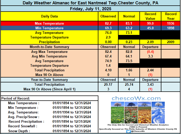
E PA/NJ/DE Summer 2025 Obs/Discussion
ChescoWx replied to Hurricane Agnes's topic in Philadelphia Region
Partly sunny today and continued warm and muggy with temperatures today and the rest of the week mainly in the mid to upper 80's. Some of the lower and warmer spots may touch 90 degrees today and again on Tuesday. Higher ridge locales are likely to get no higher than the upper 80's. Shower chances ramp up yet again by Sunday night into Monday. Rain chances lessen much of the work week before increasing again by Friday.
-

July 2025 Obs/Disco ... possible historic month for heat
HoarfrostHubb replied to Typhoon Tip's topic in New England
Rains in Maines -

July 2025 Obs/Disco ... possible historic month for heat
Damage In Tolland replied to Typhoon Tip's topic in New England
https://x.com/bennollweather/status/1944030233297842337?s=46&t=dhcbvkjmRcyBVQtDxJ3lRg -

July 2025 Obs/Disco ... possible historic month for heat
dryslot replied to Typhoon Tip's topic in New England
Best storm of the season, Frequent lightning, Thunder and no warning. -

July 2025 Discussion-OBS - seasonable summer variability
nycwinter replied to wdrag's topic in New York City Metro
i thought the amoc was slowing down if that continues and it stops would that not mean a colder europe in the future?