All Activity
- Past hour
-
@MN Transplant final measurement?
-
Euro snow depth map seemed to do pretty well with this.
-

E PA/NJ/DE Spring 2026 Obs/Discussion
Ralph Wiggum replied to PhiEaglesfan712's topic in Philadelphia Region
Right, sun angle and stuff -

E PA/NJ/DE Spring 2026 Obs/Discussion
PhiEaglesfan712 replied to PhiEaglesfan712's topic in Philadelphia Region
Yeah, that would be like if in the summer we went from 100 one day to 59 and rainy the next. -
Yeah, same out here now with light snow. It had been spitting flakes most of the day and the very light stuff earlier didn't last much longer after my post about it.
-
I just checked some weathers stations that are not sheltered and am seeing 60 to 70 mph gusts. Unreal
-
Big flakes here now
-
35 and snow.
-

80 Degrees to Ripping Snow: March 12th
PrinceFrederickWx replied to SnowenOutThere's topic in Mid Atlantic
Heavy snow and grass has caved. I knew we would do it! -
Some light wet snow has begun here
-

Richmond Metro/Hampton Roads Area Discussion
wasnow215 replied to RIC Airport's topic in Mid Atlantic
Has to be highest temp the day before and morning of before snow ever in this whole area. -

Rain/Thunder and Anafrontal Snow
Stormlover74 replied to WeatherGeek2025's topic in New York City Metro
39 with wet snow -

80 Degrees to Ripping Snow: March 12th
Winter Wizard replied to SnowenOutThere's topic in Mid Atlantic
67 degrees on 11/11/95 -
Let's do it again on April 15!
-

Central PA Spring 2026 Discussion/Obs Thread
Itstrainingtime replied to Voyager's topic in Upstate New York/Pennsylvania
-
Reasonable. I'm in between, so a B for mby is consistent with your grading of Frederick and DC south.
-

E PA/NJ/DE Spring 2026 Obs/Discussion
JTA66 replied to PhiEaglesfan712's topic in Philadelphia Region
But Ralph, that’s unpossible. Snow can’t accumulate after March 1st -
I had to leave the house at 130 so had my wife just measure and 1.4”!!!
-
Richmond Metro/Hampton Roads Area Discussion
wasnow215 replied to RIC Airport's topic in Mid Atlantic
Wakefield JUST NOW put out a statement. Not a peep until now. Poor job. Models were very consistent inside of 36 hours. -
Now? It’s a bright cloud deck in Greenfield with no precipitation.
-
One of the biggest weather turnarounds i have ever seen. And tomorrow we are going to have a warm-up with south winds 15-25, lol
-
I might downgrade after this event lol. But seriously, this is a B- tops in Frederick, and that’s being generous. I gotta think it’s a A- minimum for DC south. They’re the new mid Atlantic winter overloads.
-
I lived in Boulder for a year and this tops any temp swing snowstorm we got there.
-

E PA/NJ/DE Spring 2026 Obs/Discussion
Hurricane Agnes replied to PhiEaglesfan712's topic in Philadelphia Region
After 2 days of highs of 80, I have fatties flying (earlier had some trace pingers). Made it up to 64 as a high before the bottom fell out. Currently SN with little or no stickage, and 35 with dp 33. -
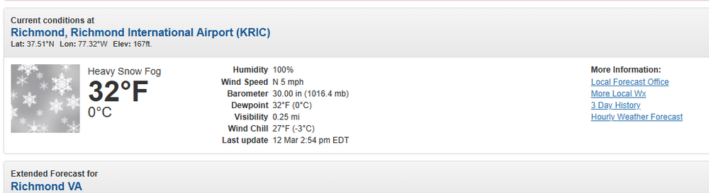
Central PA Spring 2026 Discussion/Obs Thread
Itstrainingtime replied to Voyager's topic in Upstate New York/Pennsylvania
Yesterday in Richmond, the high was 88 degrees. At 6am this morning it was 74. They are currently reporting Heavy Snow and 32 degrees. Roads are covered. Already up to 2" on grassy surfaces. Yesterday it was legit hot. Incredible.


.thumb.png.4150b06c63a21f61052e47a612bf1818.png)

