All Activity
- Past hour
-
snow reports and radar from Michigan
-

Snowstorm potential 12/14/2025
SnowGoose69 replied to WeatherGeek2025's topic in New York City Metro
Yes I believe it is having some impact, not sure its a ton of the reason but that event being more washed just based on usual tendencies when two waves are in fairly close proximity helps -
Snowstorm potential 12/14/2025
SnowGoose69 replied to WeatherGeek2025's topic in New York City Metro
Main reason I want this to happen is it increases the odds the Giants lose a game that is very winnable.... -
Snow mixing back in now. The lake effect squall forecast on the HRRR looks impressive this afternoon. Should rip for a couple of hours.
-

Snowstorm potential 12/14/2025
Physicsteve replied to WeatherGeek2025's topic in New York City Metro
Seems like Friday is petering out and headed south but hopefully that translates to a better outcome on Sunday. I’ll invoke 2 rules from the handbook and sacrifice Friday for Sunday while also needing the current clipper to exit so we get a better handle on the weekend. -
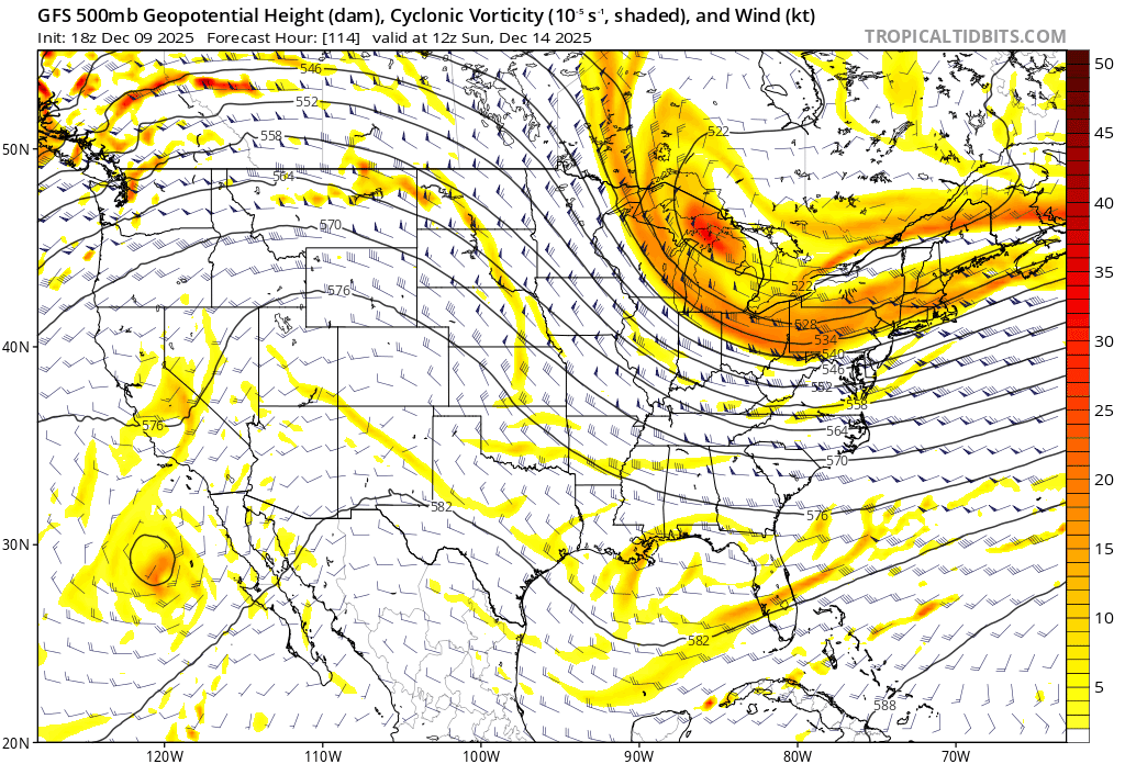
Nice right entrance region of the jet max over us also around 6-12z on the gfs.
-

December 2025 Short/Medium Range Forecast Thread
nrgjeff replied to John1122's topic in Tennessee Valley
Snow for Hanukkah. Severe for Christmas. Checks out! Getting off my torch horse.. The following teleconnections reveal something like the chart below Days 16-20 which is Christmas and the following weekend. Maybe delay to New Year. Maybe the other way, shallow cold airmass brings a colder verification in Tennessee. Who knows? Cold air supply in Canada MJO tracking back through 7-8 colder phases WPO ride still rex blocking North Pac, if we can boot any Alaska trough Strato is still active / warm Do not share for any commercial purposes. This was posted yesterday afternoon, so I feel like it's OK to share just here.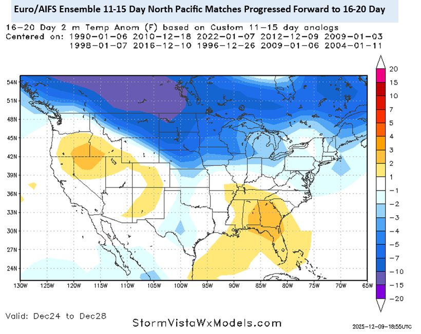
-
hey what happened to Uncle? and Rjay? Do they still post here?
-
Given how chaotic/fast the pattern is we won’t know more until tomorrow evening probably. Hopefully we can thread the needle and have a decent enough event but it will be a small window with a vigorous enough shortwave taking a good track. Lots of ways it can go wrong.
-

December 2025 Short/Medium Range Forecast Thread
Carvers Gap replied to John1122's topic in Tennessee Valley
It is gonna take me forever to remember this PowellVolz. LOL. I have said it before, but glad to see you back posting here. -

December 2025 regional war/obs/disco thread
TauntonBlizzard2013 replied to Torch Tiger's topic in New England
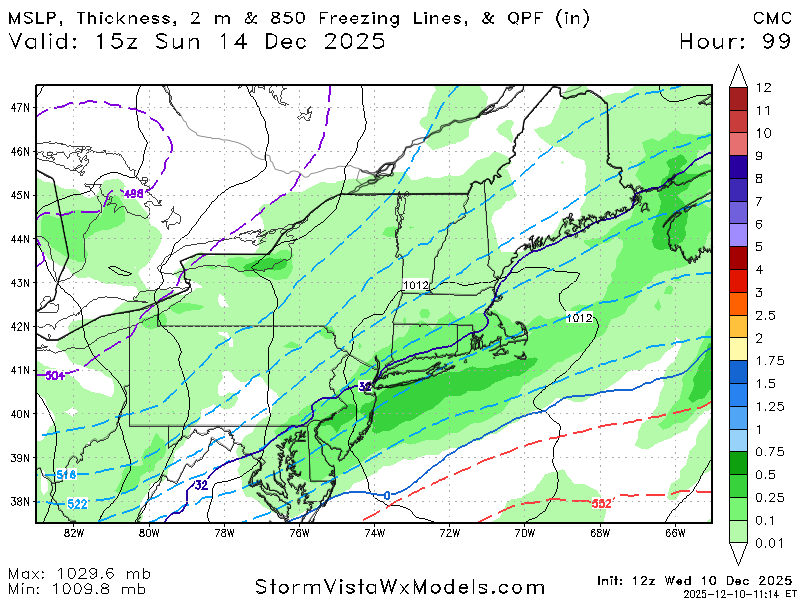
The CMC was actually pretty close to getting eastern areas with heavier stuff -

Snowstorm potential 12/14/2025
Franklin0529 replied to WeatherGeek2025's topic in New York City Metro
Going down to Atlantic City from Friday -monday. Maybe I'll see couple inches down there -
Good analysis. We want to see heights rise a bit to the east so we can get some moisture and lift up over our area. Hoping to see this trend continue a bit further.
-
I think some areas will receive a few inches while others receive only a coating and this will turn into a nowcasting event and it's impossible to predict which area of the region will receive what amounts until the storm is approaching the region and in progress probably
-
8hrs of Christmas rain. Enjoy.
-

12/12: The little Friday clipper that could? Or won't.
BlizzardNole replied to dailylurker's topic in Mid Atlantic
Enjoy! That's the way if you live in this area -- go north or south if you want snow -

December 2025 regional war/obs/disco thread
HoarfrostHubb replied to Torch Tiger's topic in New England
Its a fun drive -

December 2025 Short/Medium Range Forecast Thread
GBOVolz replied to John1122's topic in Tennessee Valley
That looks interesting . -
December 2025 Short/Medium Range Forecast Thread
Carvers Gap replied to John1122's topic in Tennessee Valley
I am watching the 12z GFS roll in right now. Through 174, it is much colder across the NA continent. Let's see if that trend continues to hold for the rest of the run. This fits the trend of modifying warmer air masses. Looks like it has the post Dec 20 cold front rolling down the Canadia Prairies. Let's see if it can push all the way SE - I am still 50/50 on whether it can make it. Nice push SE on this run. -
For future runs, watch the sharpness and how far west the SW can trend. Good signs the last couple of runs.

-
CMC is a miss north for basically PA/MD line south but did jump significantly south from 0z
-

December 2025 regional war/obs/disco thread
weatherwiz replied to Torch Tiger's topic in New England
definitely possible...the BL may be a bit torched down that way. -
December 2025 regional war/obs/disco thread
TauntonBlizzard2013 replied to Torch Tiger's topic in New England
Canadian doesn’t look bad. It’s kind of close to getting eastern areas when it really gets going just offshore -

December 2025 regional war/obs/disco thread
brooklynwx99 replied to Torch Tiger's topic in New England
CMC making the same shifts as the GFS. TPV is more favorably oriented.thumb.gif.edbc71506ec1c024e6d840e28d852f61.gif)
-
Cmc


.gif.0e0d156d3c29454b7c001ac8f238b02e.gif)
