All Activity
- Past hour
-
@Eskimo Joe Am I missing something or Mesonet not record any historical data? I know that's not the purpose but it would be nice to at least have monthly data.
-

Spring 2026 Pattern Discussion Thread
Carvers Gap replied to Carvers Gap's topic in Tennessee Valley
Frost is possible(even likely) over portions of NE TN on Sunday morning. Folks w/ gardens need to keep an eye on this. MRX no longer issues freeze or frost warnings(don't get me started!). I just about got caught a few weeks ago when I just glanced at the map and thought we were clear. Fortunately AppleWx had the temp correct, and I covered my plants. The 6z GFS has temps as low as 32 over TRI. That could do serious damage to crops which were put out early. I have already ordered some cheap covers for plants, and delayed planting cold sensitive plants. -
No one is losing snowfall right now. Why are we fighting in here?
-
Im already seeing soil cracking like its August.
-
Well it looks good for his area. Things evening out a bit. Nothing but spits and drizzle here for the past few weeks.
-
Will killing our rain chances one map posting at a time.
-
Another day of misery in Eastern Mass . Heats on this morning . Looks like 2 weeks of misery on top. Florida looking appealing . .
-

2026-2027 El Nino
snowman19 replied to Stormchaserchuck1's topic in Weather Forecasting and Discussion
This Nino is already very well coupled to the atmosphere as can be seen with the very strong STJ response. It’s really going to be bombs away this fall and winter with the El Nino/+PMM juicing the STJ, it’s going to be on steroids, something we haven’t seen in a long time -

2026-2027 El Nino
bluewave replied to Stormchaserchuck1's topic in Weather Forecasting and Discussion
Nino 3.4 responding to the kelvin wave as it’s now the 3rd warmest for the date since the early 80s.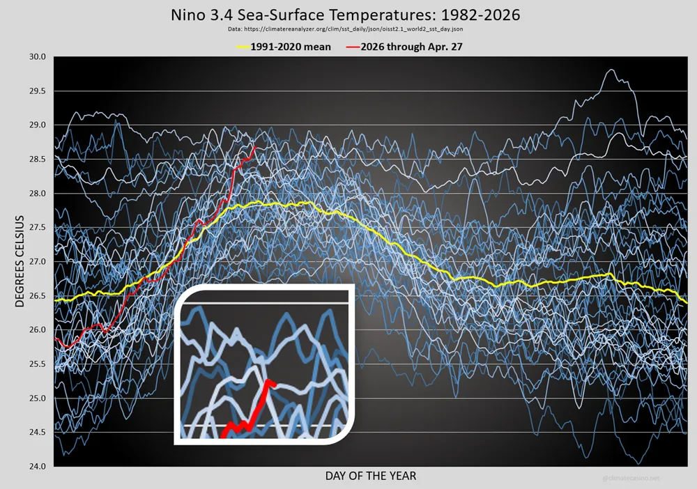
-
The one out by Stellwagen?
-

Central PA Spring 2026 Discussion/Obs Thread
mahantango#1 replied to Voyager's topic in Upstate New York/Pennsylvania
US National Weather Service State College PA · Wednesday - April 29, 2026 @ 515 AM EDT: An area of low pressure will move northeast from the Ohio River Valley and cross Pennsylvania later this afternoon and evening, bringing a soaking, beneficial rainfall. The brunt of the rain associated with this low will last for 6 to 8 hours in most places. The rain will move out of the state late tonight. -

Central PA Spring 2026 Discussion/Obs Thread
Mount Joy Snowman replied to Voyager's topic in Upstate New York/Pennsylvania
52 when I left the house. Looks like rain totals have been cut back a bit but should still be a nice soaking this evening. -
Lol, went from 2" to 1". Looks like hvy stuff tonight targeting eastern areas Sent from my SM-S921U using Tapatalk
- Today
-
It has been mostly a brown lawn issue here since late 2024. But we did have our local reservoirs running low at times. Thankfully nothing as extreme as the water restrictions areawide back in 2002. The biggest issue for agriculture this spring has been the record temperature swing. While spring record warmth is arriving earlier these days, the last freeze date has held more steady. This has resulted in the big local crop losses.
- 943 replies
-
- 1
-

-
- april showers bring may..
- rain
- (and 2 more)
-
And poof goes another one. Looks like sprinkles and a few showers incoming. We need an actual rain event really badly.
-
Let it go
-
We could.. watch if that coastal forms closer to the coast Saturday night
-

2026-2027 El Nino
PhiEaglesfan712 replied to Stormchaserchuck1's topic in Weather Forecasting and Discussion
2.56 in October 1997 -
Just like that we went from an 80% chance of rain to 40% on point click.
-
The AFD from RAH reads like “Rain will split the area today with very light amounts. Maybe an isolated storm this evening. Saturday has trended further south with the low. Amounts have decreased as well”. Going to see an expansion of the extreme drought in this area, despite the pattern change. Does look like Georgia and South Carolina see repeated beneficial rains but NC has dried out a lot on modeling
-

Texas 2026 Discussion/Observations
Stx_Thunder replied to Stx_Thunder's topic in Central/Western States
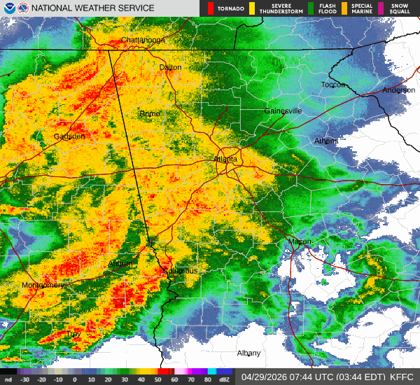
Convective initiation could begin in N-CTX early this morning along the sagging cold front (southeast of Abilene) with the first incoming shortwave out west. Even that initial batch this morning could get severe with weakening MLCIN projected. I can already see light radar returns over Midland area, moving east as of typing this. Appears to be virga (west of the dryline), and reporting cloudy skies. -
Texas 2026 Discussion/Observations
Stx_Thunder replied to Stx_Thunder's topic in Central/Western States
Despite SPC still not forecasting much severe risk in the state today, the threat (esp. large hail) is by *no means over in the state. Euro, GFS, and HRRR are all latching now onto stronger mid-level (H5 & H7) energy trailing further south through the state today. Instead of all the unrealistically forecasted ridging over the southern half the past days. Continued moderate DL shear around 50 - 60 knots, and still steep ML lapse rates of at least 7 - 8, in C & STX. But looks to remain closer to 8. Very large hail is definitely still a distinct possibility. A giant hail stone (5 in.) might not be out of the question later today over the Edwards Plateau region (west of San Antonio), with strong sfc heating likely getting into the 90s and possibly near 100 F. Especially with the dryline out there that could get intersected by the cold front. Such near extreme daytime instability (which is typical this time of year out there) could cause some initially explosive HP supercell development as some of the CAMs are indeed showing near Del Rio later today. -
Well ....it's about time!!!! Haven't seen rain like this in at least 6mos. Currently at 1.1 inches so far since yesterday. Looks like a decent amount still heading this way!
-
You were saying... Sent from my SM-G998U using Tapatalk
-
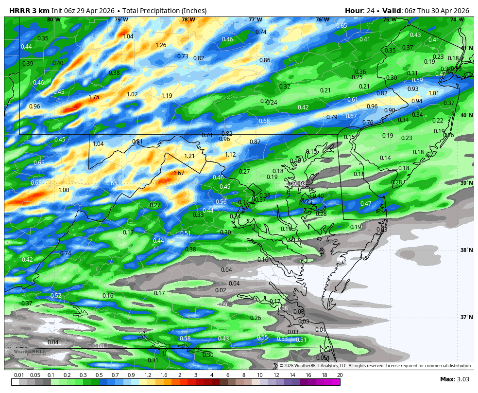
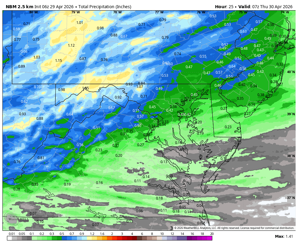
WB 6Z HRRR and NBM