All Activity
- Past hour
-
18 was nice. Shut down school for a week. Nice cold was attach to it also .
-
Honestly a lot of our best snows the past 20 years have been before or near Christmas storms. 2009 big storm area wide 10-16" 2010 Christmas snow are wide 6-12" 2017 overrunning snow area wide 4-8" 2018 big storm area wide 10-16" And by area wide I mean WNC
-
Where I am I think it’s pretty likely. Dews are in the upper 20s and wind should be about calm.
-
That is one of the more impressive eyes I can remember. Would not want to be anywhere near Jamaica right now. .
-

Spooky Season (October Disco Thread)
dendrite replied to Prismshine Productions's topic in New England
Chilly evening. 43° and breezy -

Spooky Season (October Disco Thread)
Chrisrotary12 replied to Prismshine Productions's topic in New England
November 3rd storm might have been interesting if it wasn't getting a swift kick in the rear. -
Would not be surprised to see my first frost tomorrow morning
-

Spooky Season (October Disco Thread)
CoastalWx replied to Prismshine Productions's topic in New England
There is no miracle. -
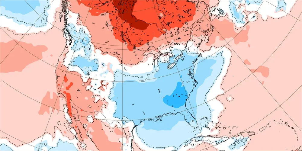
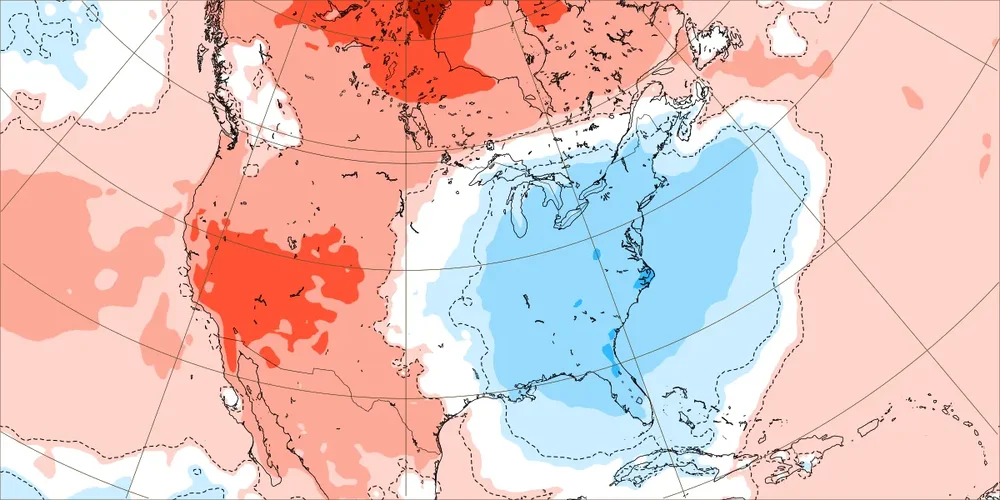
Today’s Euro Weeklies out 6 weeks for E US: - Coldest 1st 2 weeks of any run (see below) for that period thanks to a combo of an impressive +PNA and impressive ascending -NAO, which should it verify closely would be coldest for E US overall since the similarly chilly 2012 for Oct 27-Nov 9. For those curious, that period in 2012 actually had a mean near opposite weak -PNA as well as a similarly strong -NAO and weak -AO. Edit: it had a +EPO like we have now. - No long period of mild in sight with weeks 3, 5, and 6 NN and week 4 only barely AN Week 1 (Oct 27-Nov 2): Week 2 (Nov 3-9):
-
.thumb.png.4150b06c63a21f61052e47a612bf1818.png)
Spooky Season (October Disco Thread)
HIPPYVALLEY replied to Prismshine Productions's topic in New England
We both know that’s not happening. -

Spooky Season (October Disco Thread)
Torch Tiger replied to Prismshine Productions's topic in New England
Pray it misses Jamaica way way west. :/ -

Spooky Season (October Disco Thread)
ineedsnow replied to Prismshine Productions's topic in New England
Icon moved west a bit.. Melissa looks to be heading wsw again looking at satellite.. we hope for a miracle -
Spooky Season (October Disco Thread)
CoastalWx replied to Prismshine Productions's topic in New England
Maybe next year. We just don’t know. -
NOAA satellite loop hasn’t updated since early this morning. Nice day here, though…probably managed about 50/50 sun/clouds.
-
Made it to 64 before more clouds came in around 2:/2:30 and had been mostly cloudy since.
-

Spooky Season (October Disco Thread)
kdxken replied to Prismshine Productions's topic in New England
This blows. -
I still think Harbaugh might just "retire". To me he just doesn't seem to have the energy and just seems "old" in the sidelines interviews and presses. I cannot imagine Biscotti is happy with what's going on--and just because he hasn't said anything publicly doesn't necessarily mean approval (he seems to prefer to stay rather quiet during the season).
-
Season still alive, lol
- Today
-
Satellite presentation alone would suggest a near cat 5 now. Very impressive
-

Spooky Season (October Disco Thread)
WinterWolf replied to Prismshine Productions's topic in New England
Not happening. -
I believe you mean due west
-
WTNT43 KNHC 262100 TCDAT3 Hurricane Melissa Discussion Number 22 NWS National Hurricane Center Miami FL AL132025 500 PM EDT Sun Oct 26 2025 After an earlier pause in intensification, this afternoon's Air Force Reserve reconnaissance mission has found Melissa intensifying again. The minimum pressure has fallen 12 mb from this morning NOAA-P3 mission, with the last dropsonde indicating a minimum pressure of 941 mb, and the plane reported a shrinking eyewall down to 6 n mi in diameter. In addition to the low pressure, the satellite presentation of Melissa remains very impressive, with 1-minute visible satellite images from a GOES-19 meso-sector showing a very clear eye with a stadium effect. The eye temperature on water vapor imagery has continued to warm, while the thick ring of eyewall cloud tops remains between -75 to -80 C around the eye. The presentation of Melissa on radar reflectivity from Kingston, Jamaica has also improved, though there still appear to be hints of a moat forming around the inner eyewall, though without an obvious secondary eyewall formation yet. Subjective Dvorak CI-numbers from both SAB and TAFB were T7.0/140 kt, with objective satellite estimates between 132-143 kt. However, Melissa's peak winds from the last couple of recon missions have been lagging the satellite-based estimates. The last fix had peak 700 mb flight level winds of only 129 kt, but a dropsonde launched in the north eyewall also reported a 500 m layer average of 142 kt, with an earlier dropsonde in the NE eyewall with a surface wind gust of 131 kt. This data is enough to raise the maximum sustained winds of 125 kt, and given the satellite presentation, this could be conservative. Melissa continues to move slowly westward, estimated at 270/4 kt. The hurricane has been moving a little faster to the west today, and this motion will likely continue for another 12-18 hours while the narrow mid-level ridge to the north remains in place. Soon, a short-wave trough will be moving into the SE United States, and this feature should create a weakness that Melissa will turn sharply northeast into, as it gradually accelerates. The track guidance has shifted a little westward again this cycle, and the NHC track forecast was nudged a little west again, but still shows landfall on Tuesday morning along the south coast of Jamaica. There remain some timing differences thereafter, but a second landfall is anticipated along the southeastern Cuba coast by Tuesday night or early Wednesday morning. As Melissa then accelerates into the southwestern Atlantic, it will move through the Bahamas and potentially approach Bermuda by the day 4-5 time frame, with a reinforcing trough helping to kick it farther out to sea. The latest NHC track forecast is a little west in the first 24-60 h, but falls back near the previous forecast track thereafter. The track is roughly a blend of the reliable HFIP Corrected Consensus Approach (HCCA) and Google Deep Mind ensemble mean (GDMI). Now that Melissa is intensifying again, it seems more clear that the earlier pause in intensification was a temporary oscillation, and the hurricane now appears poised to intensify more in the short-term. The latest NHC intensity forecast shows a little more intensification in 12 h, but continues to show a peak intensity of 140 kt, which is supported by HAFS-B which shows landfall of Melissa as a catastrophic Category 5 hurricane. The Google DeepMind ensemble members also continue to indicate this peak, with now 48/50 members reaching this lofty intensity. However, inner-core processes like ERCs could occur at any time, and the current small eye of Melissa likely suggests an ERC could begin in the next 24 hours or so, though it is very difficult to predict these occurrences with much skill. After landfall in Jamaica, Melissa will likely weaken some due to the interaction with that Island's high terrain, but it is still expected to be a major hurricane when crossing the Cuba coastline on Tuesday night. After emerging into the southwestern Atlantic Ocean, increasing vertical wind shear should continue gradual weakening through the end of the forecast, with the possibility that Melissa could start extratropical transition by day 5. The NHC intensity forecast continues to be on the high side of the guidance, but falls closer to the HCCA and IVCN aids towards the end of the forecast period. ———— Monday. FORECAST POSITIONS AND MAX WINDS INIT 26/2100Z 16.4N 77.2W 125 KT 145 MPH 12H 27/0600Z 16.4N 77.7W 135 KT 155 MPH 24H 27/1800Z 16.6N 78.2W 140 KT 160 MPH 36H 28/0600Z 17.2N 78.2W 140 KT 160 MPH 48H 28/1800Z 18.4N 77.5W 115 KT 130 MPH...INLAND OVER JAMAICA 60H 29/0600Z 20.0N 76.1W 105 KT 120 MPH...ON THE SE CUBA COAST 72H 29/1800Z 22.1N 74.4W 90 KT 105 MPH...OVER WATER 96H 30/1800Z 28.0N 69.5W 80 KT 90 MPH 120H 31/1800Z 37.0N 60.0W 70 KT 80 MPH $$ Forecaster Papin
-
WTNT33 KNHC 262055 TCPAT3 BULLETIN Hurricane Melissa Advisory Number 22 NWS National Hurricane Center Miami FL AL132025 500 PM EDT Sun Oct 26 2025 ...HURRICANE MELISSA RESUMES INTENSIFYING... ...LIFE-THREATENING AND CATASTROPHIC FLASH FLOODING AND LANDSLIDES EXPECTED IN PORTIONS OF JAMAICA AND SOUTHERN HISPANIOLA THROUGH MIDWEEK WITH HURRICANE FORCE WINDS LIKELY TO BEGIN TOMORROW... SUMMARY OF 500 PM EDT...2100 UTC...INFORMATION ---------------------------------------------- LOCATION...16.4N 77.2W ABOUT 115 MI...185 KM SSW OF KINGSTON JAMAICA ABOUT 295 MI...470 KM SSW OF GUANTANAMO CUBA MAXIMUM SUSTAINED WINDS...145 MPH...230 KM/H PRESENT MOVEMENT...W OR 270 DEGREES AT 5 MPH...7 KM/H MINIMUM CENTRAL PRESSURE...941 MB...27.79 INCHES
-
A strong NAO blocking regime is in place and will persist into early November. As a result, an extended period of cooler than normal weather will prevail through the end of the month. Tomorrow will be another cool day. Temperatures will top out in the lower and middle 50s across much of the region. Many locations outside of New York City will see readings start in the 30s. Hard freezes are likely well north and west of New York City. The unseasonably cool weather will continue through at least the middle of the week. Rain could arrive Wednesday night or Thursday. A general 1"-3" rainfall is likely late Wednesday night through Friday. There remains uncertainty about the area of heaviest rainfall. The storm will be followed by a continuation of cool weather. The ENSO Region 1+2 anomaly was -0.4°C and the Region 3.4 anomaly was -0.6°C for the week centered around October 15. For the past six weeks, the ENSO Region 1+2 anomaly has averaged -0.15°C and the ENSO Region 3.4 anomaly has averaged -0.47°C. La Niña conditions will likely continue through mid-winter. The SOI was +30.36 today. That is the first +30.00 or above figure since April 2, 2025 when the SOI reached +35.40. The preliminary Arctic Oscillation (AO) was +1.370 today. Meanwhile the NAO was -1.329. That last time the NAO was -1.000 or below and the AO was +1.000 or above was March 2, 2023. The last time it happened during fall was November 4-5, 2021. Based on sensitivity analysis applied to the latest guidance, there is an implied 51% probability that New York City will have a warmer than normal October (1991-2020 normal). October will likely finish with a mean temperature near 58.0° (0.1° above normal). Supplemental Information: The projected mean would be 1.1° above the 1981-2010 normal monthly value.
-
Just slogging due east. WEST


