All Activity
- Past hour
-
Still dry (as forecast, maybe a bit tonight). Just enough wind to wiggle the few remaining intact leaves.
-

2025 Atlantic Hurricane Season
NorthHillsWx replied to BarryStantonGBP's topic in Tropical Headquarters
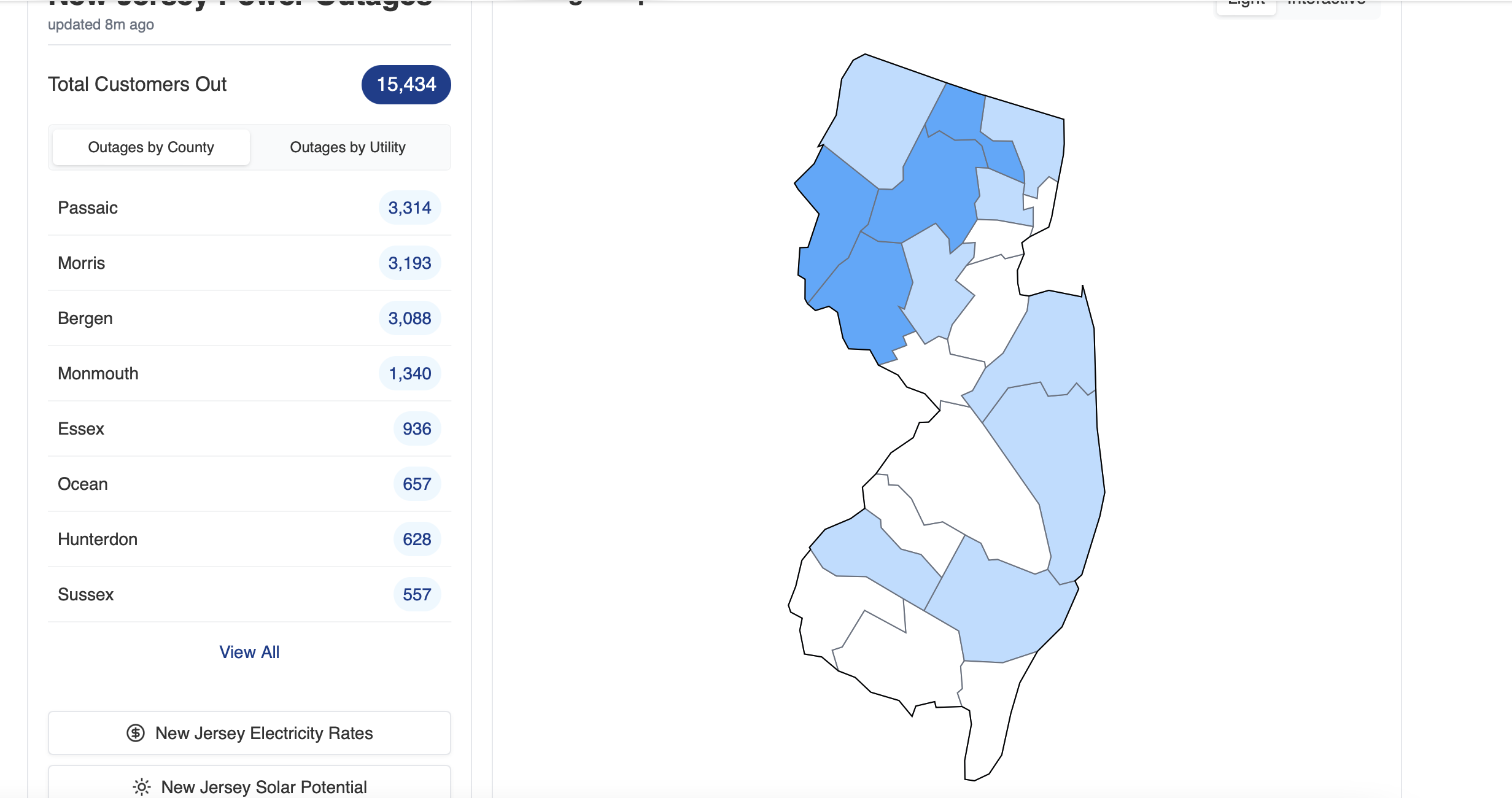
IMO it could’ve been named well before they named it. That it existed within an upper level low was why it was just what it was: a subtropical storm. Honestly a very impressive one at that to have the symmetry and sustained convection at that latitude. Would’ve loved radar from that storm because it would’ve looked like a hurricane haha. As for JB naming coastal storms, absolutely not. TWC already subjected us to that with winter storms and it’s a joke. Nor Easter’s are part of life on the east coast and honestly until this year we’d been in a very long dry spell for significant ones. We can’t name every weather system just bc it’s impactful. You’d have to start naming lows that hit the west coast too if you went that route. It’s just not a good idea. Coastal lows are very impactful but they are nothing like a hurricane and coastal towns know how to prepare accordingly as is. This one has literally 0 tropical characteristics and comparing it to Karen is like comparing an apple to an orange. Their both low pressure systems is about the only similarity. He has gone off the rails, and it’s sad because he had been one of the better Mets back in the day but it’s been so long I just cancel anything he says out as noise at this point. As for this system, lots of coastal flooding from New England to the Carolina’s and some areas of significant flash flooding in SC but overall a lot of areas saw beneficial rain. For a complicated forecast the storm ended up doing about exactly what was expected for the entire coast. -

Central PA Fall Discussions and Obs
Superstorm replied to ChescoWx's topic in Upstate New York/Pennsylvania
56F 0.31" rain total so far. -
 2.20 here so far, that heavy batch that passed over Queens/Nassau overnight helped me catch up to you guys
 -
Picked up an additional 0.02” overnight at some point. Currently thick overcast and 60.4 still breezy but nowhere near the constant gusts of yesterday. Saw a lot of inland areas recorded gusts over 40 yesterday which is very impressive for a nor Easter
-
Central PA Fall Discussions and Obs
Superstorm replied to ChescoWx's topic in Upstate New York/Pennsylvania
Bingo -

The return of the elusive Nor'easter. Drought buster or bust?
kgottwald replied to dailylurker's topic in Mid Atlantic
Just pretend you're in LA or Savannah. -
 Tidal: am virtually certain moderate CF develops at Sandy Hook area midday... long duration of minor tidal inundation. Tides still running 3' above predicted at 940A. Should make about 8' MLLW there. Not sure what OKX has but follow what ever they have including the datums they select.
 -
3.37"
-
This won’t be a popular take here, but I think articles like this do more harm than good as regards believability regarding the affects of CC in general. It has a sensationalist, “Day After Tomorrow” tone to it imho. This isn’t the way to convince nonbelievers. Some of the words/phrases used in the article were these: catastrophic, catastrophic ripples, devastating consequences, alarming, catastrophic global consequences, catastrophic outcome for all humanity I think that articles like this do more harm than good. And I’m saying this as one who’s extra concerned about sea level rise and stronger hurricanes being that I’m not far from the coast.
-
Violently agree
-
 The precipitation gradient or "cut-off" is oriented almost perfectly north to south across our area. It's a little more common to have more of a southwest to northeast orientation to the gradient.
- 578 replies
-
- 1
-

-
- heavy rain
- damaging wind
- (and 2 more)
-
 Yep, we’ve seen this before, up to .99 now. Yesterday some were questioning if anything of note would happen north of 95, NW of 287 even though the models had whatever was going to fall coming in overnight. This is pretty much exactly what I’d been expecting IMBY but I know that is subjective and location based.
 -
I can remember some Falls around here when we didn't get a freeze until November. I actually remember getting a snowfall the same time as we got our first freeze. Seems like the whole northern hemisphere is lagging.
-
I believe... it'll all get ironed out tomorrow morning OKX PNS and official climate site data inclusive of CoCoRaHs. Enjoy the nasty chilly day.
- 578 replies
-
- 1
-
-
- heavy rain
- damaging wind
- (and 2 more)
-

Central PA Fall Discussions and Obs
Mount Joy Snowman replied to ChescoWx's topic in Upstate New York/Pennsylvania
Low of 55 with .07” of rain. I am not in favor of a Rhule hire, would prefer Manny over him. But really I just prefer a wide open search to explore all avenues, and I think that’s what they’ll do. They need someone who can carry his weight schematically. Enough of the Mickey Mouse stuff on offense, scheme an actual passing game and actually develop a quarterback. There’s no more hoarding of talent with everyone getting paid and moving around. Must find an edge on the whiteboard. The rest of this season will likely be a sh$t show, but I’ll still watch ha. Onward. -
.thumb.jpeg.f5c6ba9d911ec96b3b124f8606aee58e.jpeg) Ripper of a rain band sitting on top of me now. Up to 2.25"
Ripper of a rain band sitting on top of me now. Up to 2.25"- 578 replies
-
- 1
-

-
- heavy rain
- damaging wind
- (and 2 more)
-

E PA/NJ/DE Autumn 2025 Obs/Discussion
Hurricane Agnes replied to PhiEaglesfan712's topic in Philadelphia Region
I almost got more rain this morning (0.30") than the total of the last 3 "events" (in quotes - 0.18", 0.25", 0.03" ). Rates got as high as about 1/4" per hour. Total for the month so far is 0.76". Bottomed out just before 9 am at 53 and had hit my high (so far) around 2:15 am. Currently drizzle and mist, with temp 54, and dp 53. -
 My location and the surrounding PWS in western Suffolk are well over 2”. Localized maximum not showing up on there
- 578 replies
-
- 1
-
-
- heavy rain
- damaging wind
- (and 2 more)
-
 Received .43” last 24 hours. Event total = .59”. Mist and drizzle ongoing. Temp 49. Chilly, damp and raw. Winds have pulled back from the gustiness of overnight and early this morning.
 -
Up to an 1.5” here and that coastal band is set up right over us. Beautiful baby!
-
Good BAM video. Looks like we need November and December to rock...what could possibly go wrong?!
-
 Through 9 am, rainfall amounts have been pretty much in line with expectations for the ongoing event.
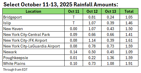
-
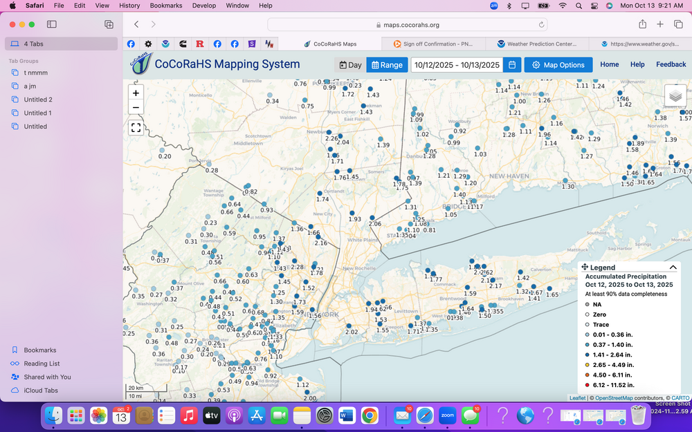
If this were winter...I'd say wait to crow until midnight tonight. MUCH more to come today. 1-2", iso heavier coasts and even interior will do ok. Convection developing per HRRR - might be quite a nasty afternoon parts of coasts. Am pretty sure some parts Li and eastern Nj will end up with 4". CoCoRaHs two day. .31 Wantage since 5P yesterday. Two day .4, heading for .6-1.0 three day totals by tomorrow morning. Click for more detail.
- 578 replies
-
- 2
-
-
- heavy rain
- damaging wind
- (and 2 more)