All Activity
- Past hour
-
(002).thumb.png.6e3d9d46bca5fe41aab7a74871dd8af8.png)
Central PA Spring 2026 Discussion/Obs Thread
ChescoWx replied to Voyager's topic in Upstate New York/Pennsylvania
A Freeze Warning is in effect tonight through 9am tomorrow morning. Be sure to protect any tender plants by late tonight. In my 22 years here the average date of my last freeze has been April 10th. Valley locations across the area have averaged later last freeze dates. High temperatures today will be almost 20 degrees below normal temperatures in the 40's. We start a warming trend through the rest of the work week before chilling down and turning wet for the weekend.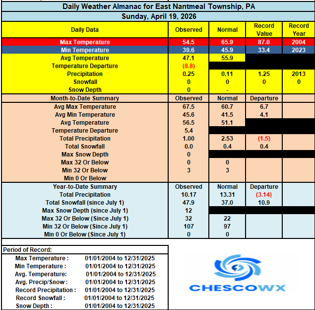
-
E PA/NJ/DE Spring 2026 Obs/Discussion
ChescoWx replied to PhiEaglesfan712's topic in Philadelphia Region
A Freeze Warning is in effect tonight through 9am tomorrow morning. Be sure to protect any tender plants by late tonight. In my 22 years here the average date of my last freeze has been April 10th. Valley locations across the area have averaged later last freeze dates. High temperatures today will be almost 20 degrees below normal temperatures in the 40's. We start a warming trend through the rest of the work week before chilling down and turning wet for the weekend.
-
This is ridiculous
-
Definitely bimodal lol Why is it so hard to just do a climo spring day in the upper 60’s
-
Just light sprinkles in Fairfax City. I can't see locations on mobile; I assume it's only the high mountains that are getting actual snow.
-
Same here, we undershot forecasts by 5-7 degrees and a lot of places reported frost
-
What a crap day. Feels weird being this bright out with the sun angle, but so cold.
-
Can confirm graupel here too. Fun.
-
Wow. Did not have graupel and thunder in McLean on my bingo card this morning.
-

Central PA Spring 2026 Discussion/Obs Thread
pasnownut replied to Voyager's topic in Upstate New York/Pennsylvania
Left cabin yesterday w/ snow/sleet combo, and had a few slushbombs hitting windshield on way to office this morning. Not sure were done w/ flakes flyin up north, but it was a fitting end to my trackin for the year. Cave's a callin, but I'll stop in once in a while. -
Destructive sunshine day-mostly cloudy here
-

Central PA Spring 2026 Discussion/Obs Thread
NepaJames8602 replied to Voyager's topic in Upstate New York/Pennsylvania
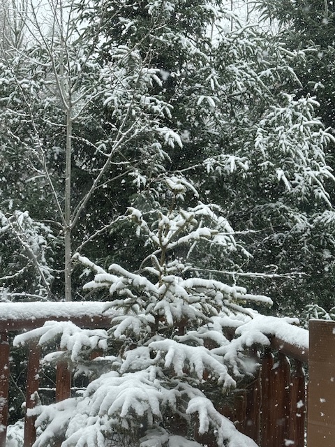
Woke up to another coating of snow and 30 degrees this am. Tonight's forecasted low is 21. -
WTF.
-
Another chilly morning with 10's (20's along the shore). Warm up this week will feel good. Birds are all over the place this morning. Woodpeckers. flickers, robins, and juncos, and some others. Very active spring activity.
-
a lot of people wearing coats this morning..
-
Saw an interesting vid about the Asian carp. It has taken over the last few decades, but an interesting development has occurred. A group started to reintroduce the Alligator Gar after they were nearly wiped out back in the 70's, and now there are areas were the carp is disappearing. The gar are starting to clean house. Gar are native to the waterways down there. Lets hope that they take care of business in the coming decades, because those carp are destructive as hell.
-
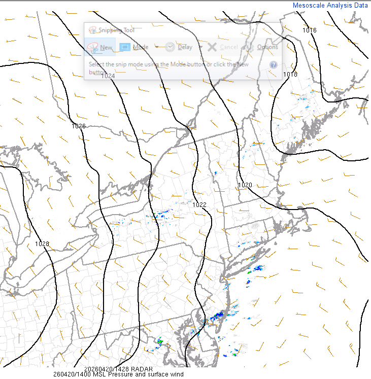
Yeah looking at mesoanlysis there definitely is a second weak feature about to slide through the region. Satellite does appear hopeful that perhaps we clear some behind that passage but I am worried that a combination of very cold mlvl temps + residual mlvl moisture is going to result a continuing of building cloud over. But maybe we transform from more stratus to more cumulus like
-
Looks like there's a secondary cold front according to WPC's most recent surface analysis. Some of this might be a response to that pressure perturbation coming thru. But it is on the move... looping vis it probably doesn't last the whole daylight. Along this end of Rt 2 we're holding out with sun for the moment. Yeah, you'll get 15 minutes before sunset hahaha.
-

E PA/NJ/DE Spring 2026 Obs/Discussion
Birds~69 replied to PhiEaglesfan712's topic in Philadelphia Region
45F/DP 37F/ Sunny Nice Fall day out there. If I hear the Ice Cream truck guy roaming around today he's selling more than just ice cream.... -
Very thick overcast making it pretty dark. Kind of reminds me of those gloomy January days when its dark out at 3:30 because of the thick overcast and sun already nearing the horizon
-
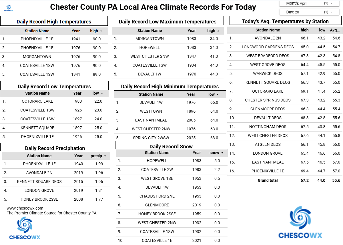
Records: Highs: EWR: 91 (1941) NYC: 90 (1927) LGA: 85 (2005) JFK: 80 (2005) Lows: EWR: 34 (1953) NYC: 24 (1897) LGA: 35 (1953) JFK: 36 (2018) Historical: 1901 - A spring storm produced unusally heavy snow in northeast Ohio. Warren received 35.5 inches in thirty-six hours, and 28 inches fell at Green Hill. Akron OH established April records of 15.6 inches in 24 hours, and 26.6 inches for the month. Pittsburgh PA established April records of 12.7 inches in 24 hours, and 13.5 inches for the month. (David Ludlum) (The Weather Channel) 1912: A tornado moved north-northeast from 5 miles southeast of Rush Center, KS across the east half of Bison, KS. Farms were wiped out near Rush Center. The loss at Bison was $70,000 as half of the town, about 50 homes, were damaged or destroyed. There were 15 injuries in town. A dozen farms were nearly wiped out. Debris from the farmhouses was carried for 8 miles. A senior man who made light of the storm was killed with his granddaughter on a farm 2 miles southwest of Bison. 1920 - Tornadoes in Mississippi and Alabama killed 219 persons. (David Ludlum) 1920: Tornadoes in Mississippi and Alabama killed 219 persons. Six tornadoes of F4 intensity were reported. Aberdeen, Mississippi was hard hit by an F4 tornado that killed 22 people. This same tornado killed 20 in Marion County, Alabama. Nine people in one family died in Winston County, Alabama. 1941: The maximum temperature for the date is 94°F. in Washington DC. (Ref. Washington Weather Records - KDCA) (Ref. Wilson - Additional Temperatures Listed On This Link) 1952 - The tankers Esso Suez and Esso Greensboro crashed in a thick fog off the coast of Morgan City LA. Only five of the Greensboro's crew survived after the ship bursts into flame. (David Ludlum) 1967: A tornado struck 5 miles north of Cyril, OK. A pickup truck driving along State Highway 8, stalled because of the wind, and then was lifted by the tornado, turned around to face the opposite direction, and set down again, without damage. The driver, who described the funnel as being "full of mud", was uninjured. (Ref. Wilson Wx. History) 1972: Severe thunderstorms struck the western parts of north Texas. Near Bonita in Montague County, flat hailstones, four to five inches in diameter, and one inch thick, did extensive damage to autos, roofs, and windows. (Ref. Wilson Wx. History) 1973: At Ada, Oklahoma a tornado spun a 33 RPM photograph record smack into a crack in a telephone pole. (Ref. Click here to see the record in the telephone pole) 1980: Billings, MT reached 90°; tying a record high for April and is the earliest 90 degree reading on record. (Ref. Wilson Wx. History) 1984: A temperature of 106 degrees at Del Rio, Texas set a new record high for April. 1987 - Fifty-two cities in the central and eastern U.S. reported new record high temperatures for the date. The high of 92 degrees at Memphis TN was a record for April, and the high of 94 at Little Rock AR equalled their April record. (The National Weather Summary) 1988 - A storm in the western U.S. brought heavy rain to parts of California. Mount Wilson was soaked with 4.15 inches of rain in 24 hours. The heavy rain caused some flooding and mudslides in the Los Angeles area, and a chain reaction collision of vehicles along the Pomona Freeway which resulted in 26 injuries. (Storm Data) (The National Weather Summary) 1989 - Hot weather spread from the southwestern U.S. into the Great Plains Region. Twenty-three cities reported new record high temperatures for the date. The afternoon high of 104 degrees at Tucson AZ was an April record, and highs of 87 at Provo UT, 90 at Pueblo CO, and 85 at Salt Lake City UT, equalled April records. (The National Weather Summary) 1990 - A fast moving Pacific storm produced heavy snow in the central mountains and the Upper Arkansas Valley of Colorado, with a foot of snow reported at Leadville. Thunderstorms in the south central U.S. produced wind gusts to 76 mph at Tulsa OK, and heavy rain which caused flooding of Cat Claw Creek in the Abilene TX area. Lightning struck the building housing a fish farm in Scott AR killing 10,000 pounds of fish. Many of the fish died from the heat of the fire. (The National Weather Summary) (Storm Data) 1991: 5.89 inches of rain fell in 24 hours at Norfolk, VA, setting a record for April. (Ref. Wilson Wx. History) 1992: A blizzard beginning on the 18th lasted through this date across the Black Hills of South Dakota. Heavy wet snow and strong winds created blizzard conditions in the northern Black Hills that led to a major power outage. About 2,000 households were without power for over 4 hours in some areas around Lead/Deadwood. Snow amounts of 2 feet were common with 30 inches falling at Lead causing major traffic problems. Northwest winds gusted to over 65 mph at Rapid City, SD and to around 50 mph in the Hills. 9.2 inches of snow at Omaha, NE (8.7 inches at the airport) set several records, including the heaviest April snow. The same storm dumped 2.7 inches of snow at Kansas City, MO for their heaviest snowfall ever so late in the season. Ahead of the storm, an F1 tornado destroyed a 40x50 foot shed and damaged a nearby garage and home two miles south of Hillsboro, WI. (Ref. Wilson Wx. History) 1993: A late season snowstorm struck parts of Nebraska and Iowa. Low pressure developed over the south central United States and tracked into southwest Missouri and finally between Des Moines and Ottumwa. Heavy snow began to fall around noon with the heaviest amounts over eastern Nebraska and southwest Iowa. 14 inches of snow fell at Hamburg and 12 inches in Sidney. 8 to 15 inches were common over eastern Nebraska and 4 to 8 inches in southwest Iowa. The snow was very wet and heavy causing tree and power line damage. In addition, some livestock losses were reported mostly with young calves. (Ref. Wilson Wx. History) 2000 Severe thunderstorms rolled from west to east across central Illinois throughout the morning. These storms produced tornado touchdowns near Illiopolis and Forsyth, and another tornado tracked from near Oreana to Argenta. This latter tornado lifted the roof off a home 2 miles northeast of Oreana, and part of a roof in Argenta was lifted off. Earlier in the morning, the storms produced winds up to 85 mph in Cass, Tazewell and Menard Counties, causing damage to buildings, trees and power lines. In Tazewell County, a radio tower in Groveland was blown over, causing $500,000 dollars damage, and near Washington, an airport hangar was destroyed, damaging 3 planes. (Ref. Wilson Wx. History) 2004: A strong F3 tornado moved across the town of Utica, near LaSalle-Peru in north-central Illinois. This tornado destroyed several homes, a machinery building, and a tavern. The roof of the tavern collapsed, killing eight people inside; many of these people had come into town from nearby mobile homes, seeking sturdier shelter. The tornado dissipated on a steep bluff on the northeast side of the city. Another tornado developed shortly afterward, crossing I-80 near Ottawa. Several other tornadoes developed across north central and northeast Illinois, affecting areas around Joliet and Kankakee. 2006 - Up to five feet of snow falls in the Dakotas. I-94 and other highways were closed.
-

Central PA Spring 2026 Discussion/Obs Thread
canderson replied to Voyager's topic in Upstate New York/Pennsylvania
It just rained. Radar was bare ha -
mm... N-E of an approximate Albany - Boston line did not register "widespread 80s and 90s" last week. Along that line did observe a couple of afternoons where it crept in but it would shunt... collapsing back into CT. By and large it was short of widespread for a large chunk of the Northeast US. Heh, I realize there is no world NE of the Tristate to Philli region, but just in deference to envious eyes made to watch warm air from their cold predicament, widespread 80s and 90s in the Northeast US is a just a wee bit of a spin.
-
Hopefully it at least produces some rain.
- Today
-
April 20 1970: Snow falls across much of Minnesota. For Monday, April 20, 2026 1901 - A spring storm produced unusually heavy snow in northeast Ohio. Warren received 35.5 inches in thirty-six hours, and 28 inches fell at Green Hill. Akron OH established April records of 15.6 inches in 24 hours, and 26.6 inches for the month. Pittsburgh PA established April records of 12.7 inches in 24 hours, and 13.5 inches for the month. (David Ludlum) (The Weather Channel) 1920 - Tornadoes in Mississippi and Alabama killed 219 persons. (David Ludlum) 1952 - The tankers Esso Suez and Esso Greensboro crashed in a thick fog off the coast of Morgan City LA. Only five of the Greensboro's crew survived after the ship bursts into flame. (David Ludlum) 1987 - Fifty-two cities in the central and eastern U.S. reported new record high temperatures for the date. The high of 92 degrees at Memphis TN was a record for April, and the high of 94 at Little Rock AR equaled their April record. (The National Weather Summary) 1988 - A storm in the western U.S. brought heavy rain to parts of California. Mount Wilson was soaked with 4.15 inches of rain in 24 hours. The heavy rain caused some flooding and mudslides in the Los Angeles area, and a chain reaction collision of vehicles along the Pomona Freeway which resulted in 26 injuries. (Storm Data) (The National Weather Summary) 1989 - Hot weather spread from the southwestern U.S. into the Great Plains Region. Twenty-three cities reported new record high temperatures for the date. The afternoon high of 104 degrees at Tucson AZ was an April record, and highs of 87 at Provo UT, 90 at Pueblo CO, and 85 at Salt Lake City UT, equaled April records. (The National Weather Summary) 1990 - A fast moving Pacific storm produced heavy snow in the central mountains and the Upper Arkansas Valley of Colorado, with a foot of snow reported at Leadville. Thunderstorms in the south central U.S. produced wind gusts to 76 mph at Tulsa OK, and heavy rain which caused flooding of Cat Claw Creek in the Abilene TX area. Lightning struck the building housing a fish farm in Scott AR killing 10,000 pounds of fish. Many of the fish died from the heat of the fire. (The National Weather Summary) (Storm Data) 2006 - Up to five feet of snow falls in the Dakotas. I-94 and other highways were closed, power was out for thousands and caused at least four deaths.