All Activity
- Past hour
-

December 2025 Short/Medium Range Forecast Thread
beavis1729 replied to John1122's topic in Tennessee Valley
That January 1989 Alaska cold snap, in my opinion, is the most impressive temperature-related weather event in recorded history relative to “normal”. Tanana, AK was the epicenter. During the last 2 weeks of that month, every single day was at least 43 degrees colder than normal. The peak of the cold was 1/27/1989, with a high/low of -60/-76…which is 60 degrees colder than normal. An absolutely unbelievable event. While Alaska has had some impressive cold waves since then (Dec. 2012 comes to mind), they have mainly been duration-driven instead of extreme intensity. Nothing has come close to the severity of January 1989. -

White Christmas Miracle? December 23-24th
moneypitmike replied to Baroclinic Zone's topic in New England
-

White Christmas Miracle? December 23-24th
40/70 Benchmark replied to Baroclinic Zone's topic in New England
I'd take that and run. -

White Christmas Miracle? December 23-24th
TalcottWx replied to Baroclinic Zone's topic in New England
I'm at 4.5" for the season. Posting this so I remember. -
The back doorings will continue until morale improves
-
 Some flakes reported on mPING in northern MD near Hagerstown with the initial finger of overrunning. Latest HRRR and current radar look decent. Hoping for a good burst of snow in the 5am - 11am timeframe. If moderate or better rates materialize, it should accumulate for most.
 -
White Christmas Miracle? December 23-24th
40/70 Benchmark replied to Baroclinic Zone's topic in New England
I'd be happy with 2-3". -
 Up to 33 here. Should fall to 31 or 32 at the onset of precip
 -
I'd feel more comfortable too with colder temperatures but this airmass should support accumulating snow in most areas away from the coastline. Yeah should drop a few degrees when the lower levels fully saturate. Before then the temps are likely to rise as clouds move in and then stabilize or fluctuate slightly. Should be approx. 30-36 until precip. starts and then 30-34 (elevation and location dependent) with mostly snow late tonight.
-
 I'm thankful that there are people like you looking out for my delicate sensibilities.
 -
December 2025 regional war/obs/disco thread
moneypitmike replied to Torch Tiger's topic in New England
LOL at the 1.4" at Pit1. It's worse than my GON childhood. -

White Christmas Miracle? December 23-24th
Damage In Tolland replied to Baroclinic Zone's topic in New England
If that verified and I get a few flurries/ dusting I will not post until spring . That’s as a jack dick Helen Keller of a map as I’ve ever seen . She’s on the desk -

White Christmas Miracle? December 23-24th
CoastalWx replied to Baroclinic Zone's topic in New England
lol I’m fine. Just sick and tired of disappointment. -

December 2025 regional war/obs/disco thread
WxWatcher007 replied to Torch Tiger's topic in New England
Bring it here -

December 2025 regional war/obs/disco thread
Go Kart Mozart replied to Torch Tiger's topic in New England
The surface temps look awesome for 26/27...struggles to hit 20f even down here. Who gonna thread this? -
White Christmas Miracle? December 23-24th
moneypitmike replied to Baroclinic Zone's topic in New England
Nay nay. It is their map. https://www.weather.gov/box/winter -

White Christmas Miracle? December 23-24th
Sey-Mour Snow replied to Baroclinic Zone's topic in New England
.3 - .35" from this area SW.. With generally around .15" East of 91.. I hope it's wrong just stating what it says -
 This.
This. -
White Christmas Miracle? December 23-24th
Damage In Tolland replied to Baroclinic Zone's topic in New England
It has .23 here and Seymour -
White Christmas Miracle? December 23-24th
Sey-Mour Snow replied to Baroclinic Zone's topic in New England
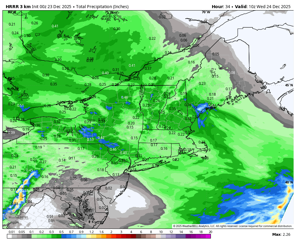
New HRRR beefed up for SWCT, unfortunately has that screw zone for the NE half of CT and a good bit of MASS until the Norlun Wednesday AM..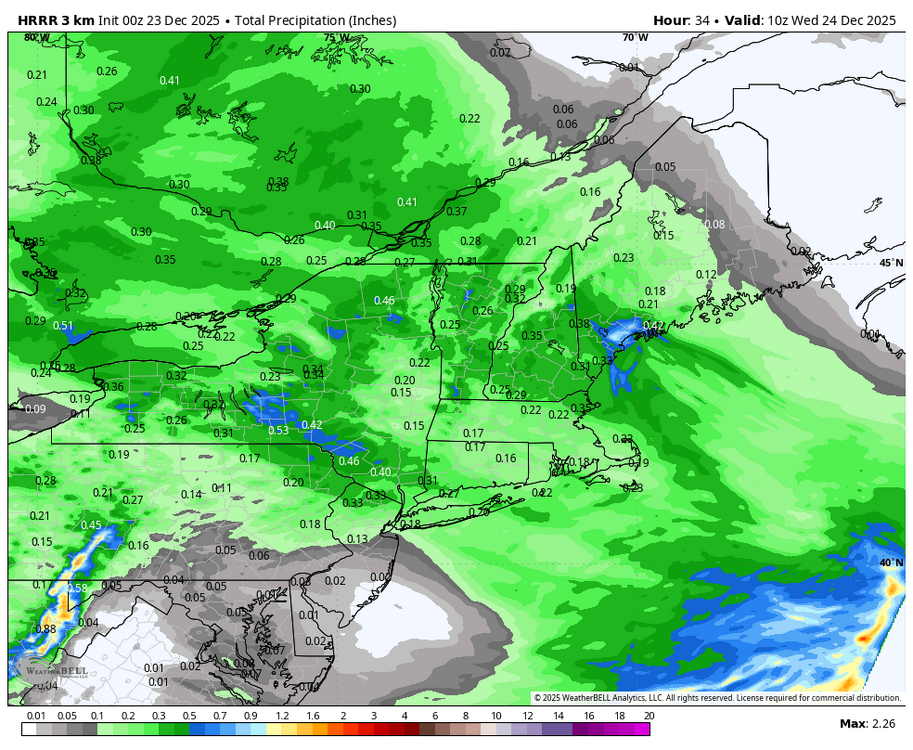
-

-
Something to watch out for. If this materializes, it would trigger a positive East Asian Mountain Torque (+EAMT), which would extend the pacific jet and help push that aleutian ridge eastward towards the west coast (+PNA).
-
Been snowing big fat fluffy flakes for a bit. Almost 2”? All air.
-
This is a look at what the month looks like to date. Had the right idea blending 2013/2024 - Jan 2025/2014 doesn't look too different from month to date, but there are hints of changes by Alaska. I don't think the overall look of the pattern will collapse for a bit. But positioning of the key feature will migrate slowly in January.
-

December 2025 regional war/obs/disco thread
Ginx snewx replied to Torch Tiger's topic in New England
-67 in the Yukon Today. Woah