All Activity
- Past hour
-
-
me looking for two snowflakes .
-
Exactly. Need that out of there !
-
It's a great looking radar for Albany. I would be pretty excited being up there right now (and they're not typically a snowy location). Should be heavy snow for several hours with great ratios. Major event incoming for them.
-
Close here in Montvale. .
-
Its way too north compared to other models.
-
I wonder if all the people that ran to Twitter like a kid to post how strong the SPV would be (assuming it meant warmth), will be as eager to post the same data has significantly changed? WED Update THURS Update FRI Update
-
Take your pick!
-

Central PA Winter 25/26 Discussion and Obs
Jns2183 replied to MAG5035's topic in Upstate New York/Pennsylvania
I have nothing but freezing rain. Car is encased in ice now Sent from my SM-S731U using Tapatalk -
Radar says snow but eyes say virga. Nothing falling in little ferry.
-

26th-27th event, coming at us like a wounded duck.
vortex95 replied to Go Kart Mozart's topic in New England
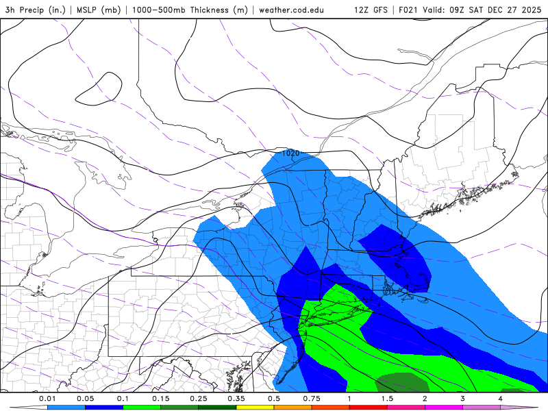
You have solid high RH at 700 and 500 mb on the NAM/GFS thru 12z Sat. Synoptic snow superimposed on OES? I don't see an issue, esp. in Weymouth! Seeding the OES from above, dancin' in the streets time for CoastalWx? LOL. And the 18z NAM shows actually shows an little higher QPF band pointed right at Weymouth, and 18z HRRR shows 5" right over Weymouth. 12z GFS had a broad slightly higher QPF area over ern MA.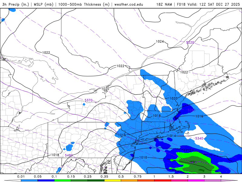
-

26th-27th event, coming at us like a wounded duck.
WinterWolf replied to Go Kart Mozart's topic in New England
Arctic sand accumulates Paul…just not very well or efficiently. I’m gonna go out on a limb and say it’s still snowing and accumulating well past 10 pm imo. -

26th-27th event, coming at us like a wounded duck.
bristolri_wx replied to Go Kart Mozart's topic in New England
Haven't made a map in a while. Also testing a web app I created using ChatGPT to build snowfall forecast maps in a web browser.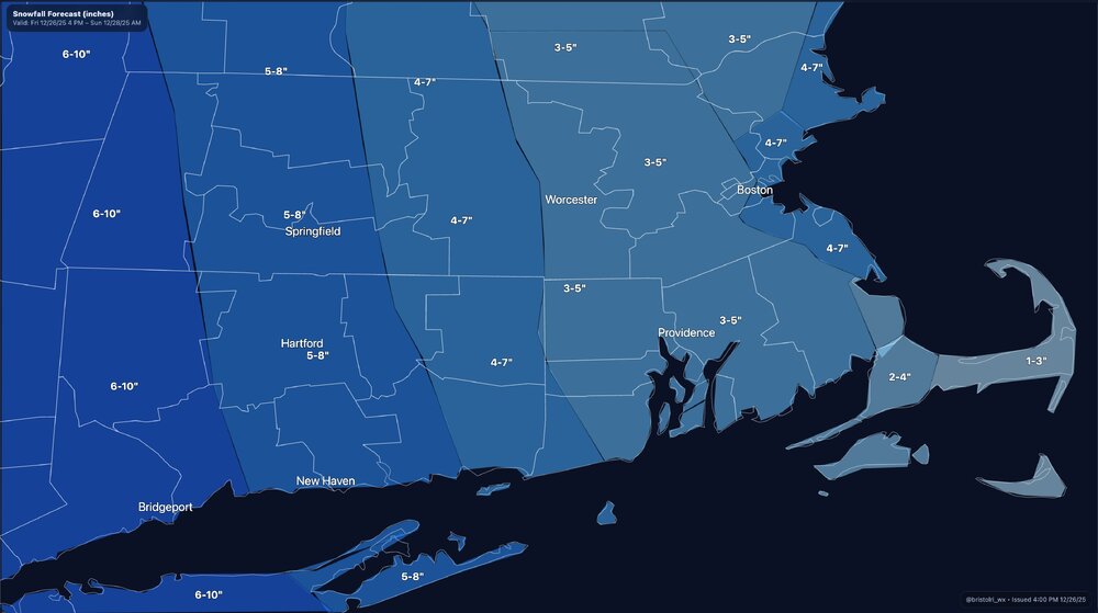
-
Doesn't seem funny to me. Neither does the matching radar.
-

Central PA Winter 25/26 Discussion and Obs
canderson replied to MAG5035's topic in Upstate New York/Pennsylvania
Sleeting hard -
Going to the bar tonight in a snowstorm should be my highlight of the year. Ill take pics for sure. 24/9f nwbx. Awaiting the snow.
-

26th-27th event, coming at us like a wounded duck.
The 4 Seasons replied to Go Kart Mozart's topic in New England
lets go
-
[emoji443]and the model runs, are a thin disguise [emoji445] .
-
Of course. It's just interesting that despite the warming we've seen, over the short term there can still be some very cold periods regionally. This convo started, of course, with short term extreme warmth examples - which also happened to a slightly less warm degree 100 years ago.
-

Central PA Winter 25/26 Discussion and Obs
Mount Joy Snowman replied to MAG5035's topic in Upstate New York/Pennsylvania
28/22 with everything already iced over and what appears to be a heavy batch of sleet on the doorstep. -
Radar filling in nicely and looking good but nothing hitting the ground by me yet,,,,,New City Rockland County checking in,,,,,,,that is all
-

26th-27th event, coming at us like a wounded duck.
Baroclinic Zone replied to Go Kart Mozart's topic in New England
So NWS usues Grib2 files I believe and you can download an app to view that data. I just tried it on my iPad. Found an app and it has access to that NBM model data. May horse around with it more. Free for 10 days. It’s like $30 one time fee for lifetime access. LuckGrib is app. -

Boxing Night Snow/Sleet/Ice Dec 26-27 Storm Thread/Obs.
Kevin Reilly replied to Mikeymac5306's topic in Philadelphia Region
40% Sleet / 60% rain 28f humidity 51% dewpoint 13f -
Next political post is an outright ban. This is a weather forum.
-
Plainfield


