All Activity
- Past hour
-
Would be fitting here for this winter

-
@WinterWolfalways appreciates these in-depth dives on the ramifications/feedbacks of CC.
-

2026-2027 El Nino
40/70 Benchmark replied to Stormchaserchuck1's topic in Weather Forecasting and Discussion
If we all need to take a mulligan next winter to vanquish the west-warm pool once and for all, sign me up. Despite a very favorable northern Pacific and polar domain this past season, it was still like pulling teeth to get bonafide coastals ....really just the blizzard, which bent me over, anyway. The dearth of residence time and amplification of the MJO in phase continued, as well. That being said, I have always maintained that Mother Nature will find away to achieve balance, and perhaps the burgeoning El Niño is the vehicle through which said balance will be achieved. I'll begin assessing next season in earnest early this summer...but taking a breather for now. -
53 and sun at 11 am in Fallston- feels amazing after the icebox again this week.
-
(002).thumb.png.6e3d9d46bca5fe41aab7a74871dd8af8.png)
E PA/NJ/DE Spring 2026 Obs/Discussion
ChescoWx replied to PhiEaglesfan712's topic in Philadelphia Region
More importantly just 6 days till Phillies opening day! Go Phillies!! -
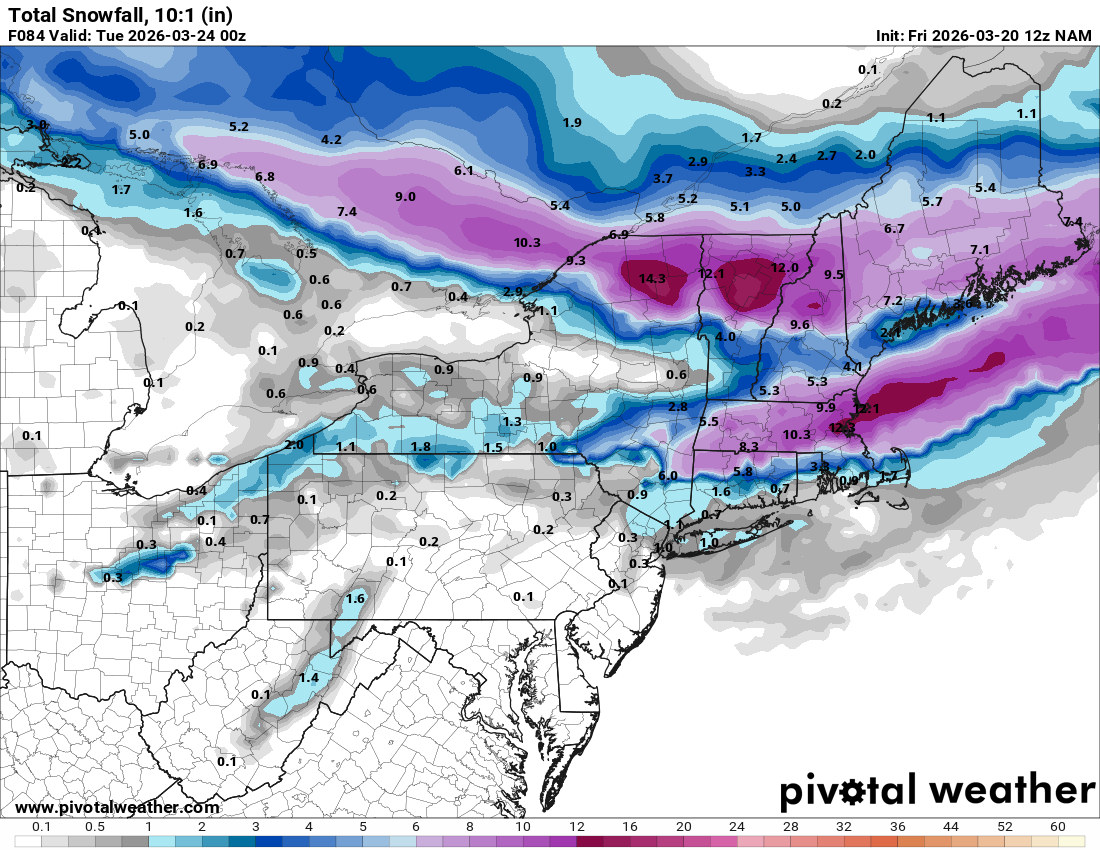
12z Nam lol.
-
It was phenomenal. It sucks too because the show ended with a massive cliff hanger. They did the movie I think it was after the show ended and were supposed to do a part 2 but it just never materialized. I think there are some channels (I see it on Hulu and Pluto TV) which plays episodes all the time.
-
He died also ? Rip Mr Morris. What a morning. First Norris and now Morris.
-
sunday could have a legit hailer threat for a lot of the OV, 2k+ cape on the NAM & pretty steep lapse rates (7-8C/km)
-
-
No not me. I doubled checked and I recorded 11.2 from that storm. Elevations in Highland Mills run from 450 to 900 feet. I'd just stick with the 11.6 report a half inch variation in town is pretty common depending where in town you reside.
-

2026-2027 El Nino
snowman19 replied to Stormchaserchuck1's topic in Weather Forecasting and Discussion
-
This must have been something AK 81 hour storm (radar from this week) https://x.com/i/status/2034432500596904102
-
CNN confirms Chuck Morris passing fwiw
-
These jokes are spreading like wildfire lol
-
I use to watch that show all the time. I think i have to start watching reruns again.
-
86 years old, it happens
-
March 20 1991: An early season tornado hits Faribault county from Bricelyn to Wells. For Friday, March 20, 2026 1924 - A late winter storm in Oklahoma produced nearly a foot of snow at Oklahoma City and at Tulsa. (David Ludlum) 1948 - The city of Juneau received 31 inches of snow in 24 hours, a record for the Alaska capitol. (20th-21st) (David Ludlum) 1984 - A severe three day winter storm came to an end over the Central Plains. The storm produced up to twenty inches of snow in Colorado, Nebraska and Kansas, and left a thick coat of ice from eastern Kansas across northwestern Missouri into Iowa. (Storm Data) 1987 - A storm produced blizzard conditions in Wyoming and eastern Nebraska, and severe thunderstorms in central Nebraska. Snowfall totals ranged up to 12 inches at Glenrock WY and Chadron NE. Thunderstorms in central Nebraska produced wind gusts to 69 mph at Valentine, and wind gusts to 76 mph at Bartley. (Storm Data) (The National Weather Summary) 1988 - Squalls in the Great Lakes Region left up to eight inches of new snow on the ground in time for the official start of spring. Unseasonably warm weather prevailed in the western U.S. Seven cities reported new record high temperatures for the date, including Tucson AZ with a reading of 89 degrees. (Storm Data) (The National Weather Summary) 1989 - Snow and high winds created blizzard conditions in western Kansas to usher in the official start of the spring season. Thunderstorms produced severe weather from east Texas to Alabama and northwest Florida, with nearly fifty reports of large hail and damaging winds during the afternoon and evening hours. (The National Weather Summary) (Storm Data) 1990 - The northeastern U.S. was in the midst of a snowstorm as spring officially began at 4 19 PM. Snowfall totals in the Green Mountains of Vermont ranged up to thirty inches, and up to 15 inches of snow was reported in the Catskills and Adirondacks of eastern New York State. Totals in eastern Pennsylvania ranged up to 12 inches at Armenia Mountain. The storm resulted in one death, and forty-nine injuries. (The National Weather Summary) (Storm Data) 2005 - An F1 tornado hits South San Francisco. Trees are uprooted. At least twenty homes and twenty businesses are damaged, including the city's new fire station. 2006 - Grand Island, NE, receives 17.8 inches of snow in 24 hours, breaking the old local record for the most snowfall in a day by 4.8 inches. 29.7 inches in 48 hours also breaks a record.
-
Natural A/C not always welcome. I get it!
-

Phoenix Experiences Warmest February and Winter on Record
GaWx replied to donsutherland1's topic in Climate Change
Fwiw this article was just released: https://www.yahoo.com/news/articles/early-southwest-heat-latest-parade-070743575.html Note this paragraph: “Climate scientists at World Weather Attribution did a flash analysis — which is not peer-reviewed yet — of whether climate change was a factor in this Southwest heat wave. They compared this week's expected temperatures to what's been observed in the area in March since 1900 and computer models of a world with climate change. They found that ‘events as warm as in March 2026 would have been virtually impossible without human-induced climate change.’” Any opinions about this article? -
Going to be a beautiful day with highs around 50 imby. Lots of snow to melt. Astro Spring today, so might as well get it going.
-
As an increasing frequency of observation, I argue that's been occurring less in summers over recent decade(s). There's a plausible reason for it too. I believe there is an emerging resonance feedback ( constructive interference) between the perennial rest state of the flow over the N/A continent, and the CC-related augmentation of heat potential. Combining those to background factors, favors in other words. Longer version: First, the perennial rest state pattern across N/A features a flat ridge tendency in the west that downstream flattens out to an impression of trough in the east, before the flow escapes out into the Atlantic. That means that at all times there is an exertion for ridging in the west, much to the chagrin of the "stop" and "shits" emoji wielding assholes on the forum. It's just that it's not 50/50. It's like a 42/58 thing heh. Second, warm air means higher heights. Now, when where there is heat in the W and SW, that means you have to combine those aspects - such that this results a resonant feedback ( constructive interference) between the fixed background state and the transience of the warm weather's wave function passing through. In short, the feed back enhances itself when that duality super-imposes ( synoptically). And since neither the back ground fix exertion is ever leaving, nor is CC going the other way... As an after-note, this lends to the hypothesis that exaggerated ridges are sort of robbing eastern N/A from experiencing these synergistic heat bursts that have been occurring acround the world. Pac NW/June of 2021 ... the few times in NW Europe. Australian. SE Asia springs... etc. Those regions are not as "protected" by N/A built in circumstance of heat deflection. I think this is why NW NE and SE Canada have seen an uptick in the April and early May heat waves...because the DP side of all this hasn't seasonally moved into those regions, such that early heat slips that one mitigating factor, and only has to then overcome the background fixed state. Which the pattern does some times. I mean..this is not an absolute deliminator process at large scales - it's a 60/40 thing. And, by the time we get to mid/late June+ ... the CC -charged footprint teaming up with the background fix state, then adding DPs holding the temps down ... you know, it fits. Because we are contributing our warmth to the total warming pot in night times lows, which in the summer, are highly modulated by the DPs at that end of the diurnal temperature cycle. I think if there's ever a time when that 40 side of the 60/40 ( hypothetical ) delivers a shock and awe heat burst N-E of the Mason Dixie, it will probably be favored to occur in that mid May to mid June window. By July, we'll probably be limited to the 96/75 + upstream continent ozone reflecting particles type heat.
-
He’ll be ok. Death had a near Chuck Norris experience.
-
Three hours of feathers 10A-1P yesterday, 0.1-0.2" on the road and leaves, 0.4-0.6" on the old snow (maybe 75% cover in the woods) on 0.01" LE. I called it 0.3" SN.\ GYX "at least, most likely, 10% chance" thru 008Z Monday is 0.5/6/12. Probably closest to the 0.5" as the parade of midgets continues.
-
that would be january, not march. march usually features enough ups to compensate for the downs.


.thumb.jpg.ad3a2e31d30aff035044689b311a0540.jpg)


