All Activity
- Past hour
-

Feb 22nd/23rd "There's no way..." Storm Thread
Climate175 replied to Maestrobjwa's topic in Mid Atlantic
A cave is gonna happen in one direction or another. GFS vs Euro tug of war LOL. -
I thought today was the day when it comes on shore out west? I could be talking out of my ass though?
-

Central PA Winter 25/26 Discussion and Obs
pasnownut replied to MAG5035's topic in Upstate New York/Pennsylvania
plenty of time for that to happen.... or not. lol with other models coming back around to the storm idea, at least that consensus is forming in a favorable way. pretty wide goalposts tho and we are on the far left side. Starting to feel like a plowable event is looking like a good possibility. -
yeah it's like pulling teeth most years to get anything decent outside of a day or two in April
-

Feb 22nd/23rd "There's no way..." Storm Thread
winter_warlock replied to Maestrobjwa's topic in Mid Atlantic
I can imagine it.. in fact I'm praying for it!! -

Feb 22nd/23rd "There's no way..." Storm Thread
Paleocene replied to Maestrobjwa's topic in Mid Atlantic
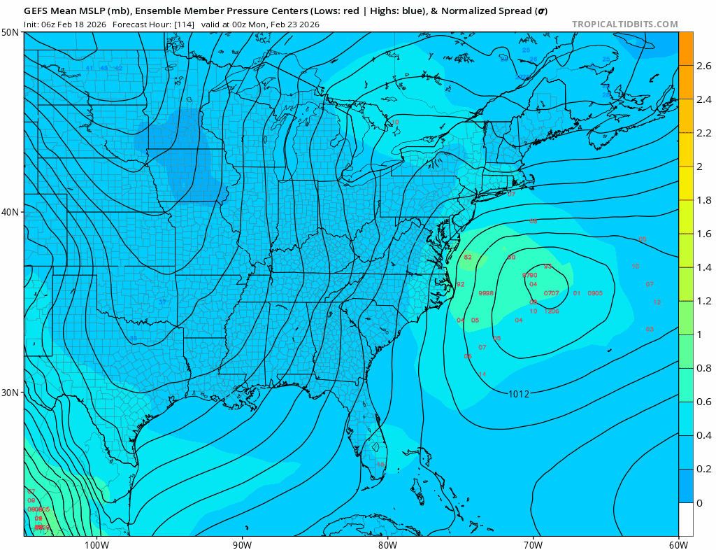
GEFS really leaning into the tucked solution as we get closer. At hour 84, the OP run that just annihilated most of us was well west (basically onshore) of where the offshore cluster is.
-
Yes, there were recon data yesterday at 18z and 00z in the eastern Pacific. Looks like some recon data is scheduled again for 00z this evening.
-
I want summer. I love warm weather but spring here is horrible. Especially April.
-

“Cory’s in NYC! Let’s HECS!” Feb. 22-24 Disco
CoastalWx replied to TheSnowman's topic in New England
If I was there I’d probably sell the gfs pretty easily. I know easier said than done. -
Crazy model runs for the mid-atlantic. GFS has 30" for DC and the Euro 2". 3-4 days out now.
-

Feb 22nd/23rd "There's no way..." Storm Thread
SnowGolfBro replied to Maestrobjwa's topic in Mid Atlantic
At this lead time that is pretty normal. Once you get inside 3 days it’s better to lean on operational models. Of course the GFS is making that hard here lol -
Wait till at least friday night to write this storm off. Still early for now. This could still be maybe a strip of 3 to 6" for the region which is still fine to close out the winter
-
That is this decade since it seems to alternate. 90s a lot of March snowstorms. 2000s very few. 2010s a lot of March Snowstorms. 2020s not many That being said there is no reason the coastal plain cannot get one this decade.
-
Feb 22nd/23rd "There's no way..." Storm Thread
winter_warlock replied to Maestrobjwa's topic in Mid Atlantic
If euro shows anything that resembles what GFS just showed, this forum will lose their minds! -

Feb 22nd/23rd "There's no way..." Storm Thread
LeesburgWx replied to Maestrobjwa's topic in Mid Atlantic
I mean, this is crazy that it looks like this -

“Cory’s in NYC! Let’s HECS!” Feb. 22-24 Disco
40/70 Benchmark replied to TheSnowman's topic in New England
1000%....I keep rolling my eyes at the "this whiff looks better aloft posts"...no offense, I'm sure it's perfectly sound and valid analysis by great mets and hobbyists alike, but that simply won't cut it. I said this earlier, but notice how all of the non-GFS guidance is a display of a thousand and one ways to miss...yea...they're different, and are waxing and waning....OFFSHORE. This isn't day 6. -
You guys keep me young.

-
GWDLT
-
2-3 and 1-2?
-
Yeah we can at least agree with him this time that he’s not getting much from this one. Maybe an inch or two on Saturday though depending on mesoscale stuff.
-

“Cory’s in NYC! Let’s HECS!” Feb. 22-24 Disco
Sey-Mour Snow replied to TheSnowman's topic in New England
Ya I'm in the same boat .. I'd take a wind driven 4-8" snowfall to end the season though.. As is we need a miracle to get a big dog like GFS has over DC - IF EURO doesn't join us at 12z then it's virtually impossible IMO -

“Cory’s in NYC! Let’s HECS!” Feb. 22-24 Disco
Kitz Craver replied to TheSnowman's topic in New England
All these coastals have had stupid double lows or conflicting convection out east. -

Feb 22nd/23rd "There's no way..." Storm Thread
wasnow215 replied to Maestrobjwa's topic in Mid Atlantic
I've kind of lost respect for ensembles a little bit. Basically they just mirror the regular model runs just more spread out -
Anthony, you go back and forth wayyyy to much brother..... you need to take a breather LOL
-

Feb 22nd/23rd "There's no way..." Storm Thread
SnowenOutThere replied to Maestrobjwa's topic in Mid Atlantic
What is the mechanism behind storms which are able to throw moisture hundreds of miles back west even when weaker and then storms like this that can barely reach a hundred miles with their precipitation?


.thumb.jpeg.1d2958065f007d9e7218a8c935ea8246.jpeg)