All Activity
- Past hour
-

Friday February 6 FROPA / WINDEX small event
wx2fish replied to HoarfrostHubb's topic in New England
Wind looks pretty meh for NH compared to a couple days ago. Really shallow mixing and mediocre winds aloft. Breezy, but were not blowing down trees like some of those runs. Definitely a better LLJ in SW NE Sat PM -

Friday February 6 FROPA / WINDEX small event
SouthCoastMA replied to HoarfrostHubb's topic in New England
Actually doesn't look great here attm. Unless there are additional shifts in store -
 Min 5.4 before the clouds arrived
 -
Friday February 6 FROPA / WINDEX small event
dendrite replied to HoarfrostHubb's topic in New England
Maybe a little NE oro assist there with the conv zone setting up right over the high terrain? -
Friday February 6 FROPA / WINDEX small event
dendrite replied to HoarfrostHubb's topic in New England
Just a few of the larger ones poking through. Like Mt Washington during the last glacial maximum. -
Looks like a spring time cycle of thaw/cold shot/repeat for the remainder of the month
-
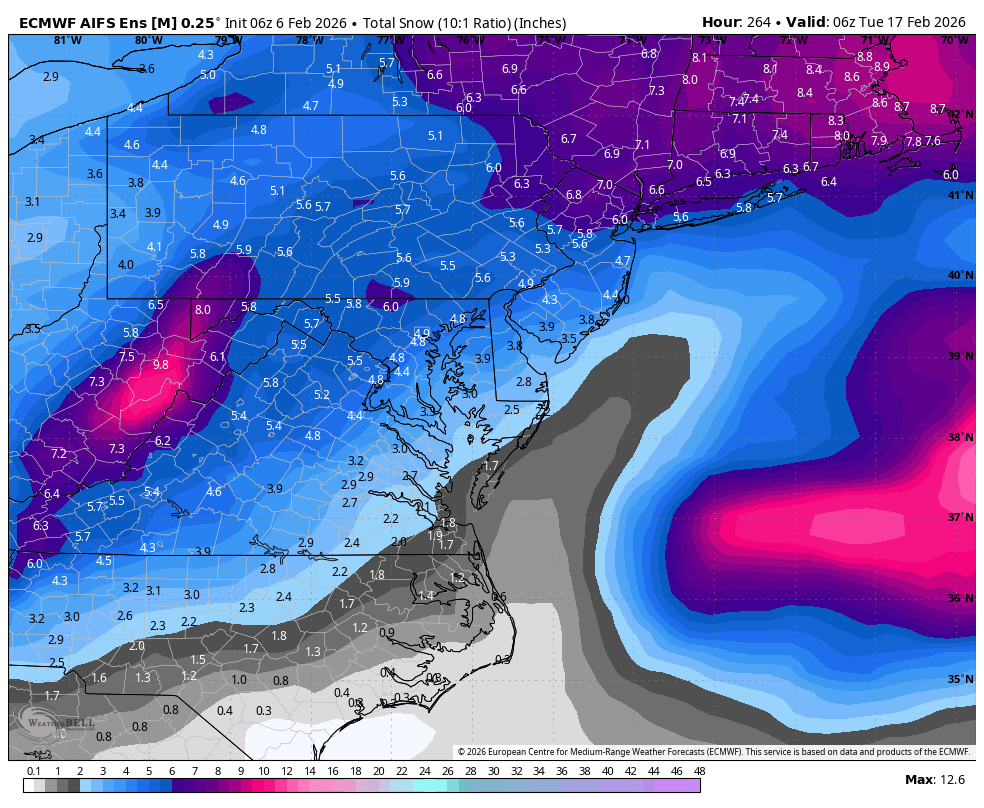
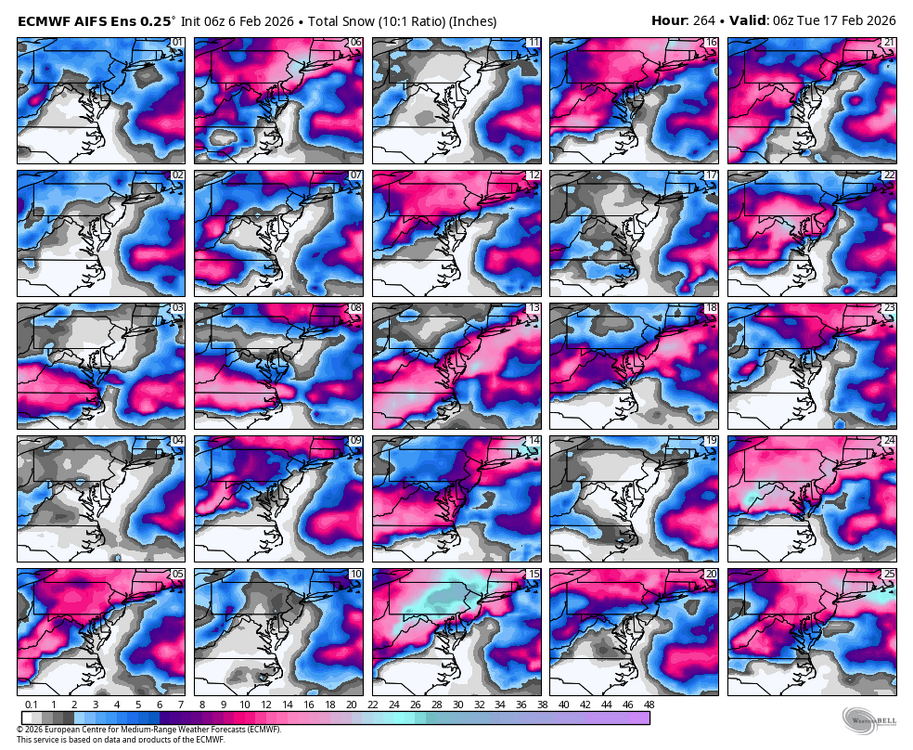
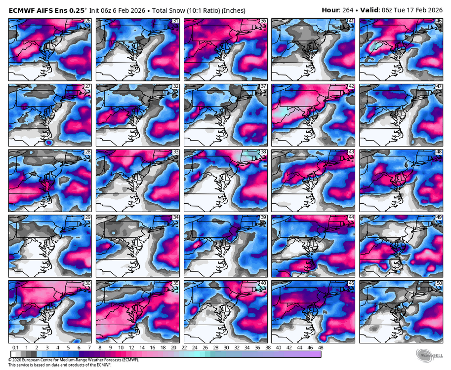
 WB 6Z EPS AI still looks good for next weekend. About 40% of members with a nice hit.
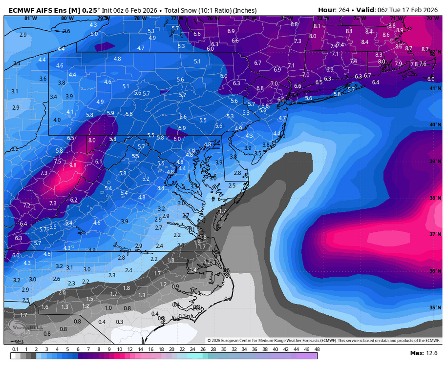
-

Friday February 6 FROPA / WINDEX small event
Kitz Craver replied to HoarfrostHubb's topic in New England
Pee stains and doggy doo still visible? Lol -

Richmond Metro/Hampton Roads Area Discussion
Ephesians2 replied to RIC Airport's topic in Mid Atlantic
06z NAM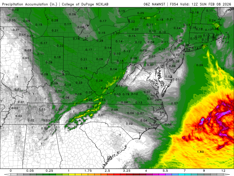
-
https://x.com/wxjerdman/status/2019729810914992195 I knew it was cold but didn't realize the impressive nature of it. January 15 - February 4 is the coldest 3 weeks of the year on avg to begin with. 2026 now ranks 3rd coldest for that 3 week stretch at Detroit in 153 years of record. Only 1918 & 1963 were colder.
-

Friday February 6 FROPA / WINDEX small event
ORH_wxman replied to HoarfrostHubb's topic in New England
06z euro starting to line up with a lot of other guidance…that’s pretty widespread advisory stuff for eastern half of into CNE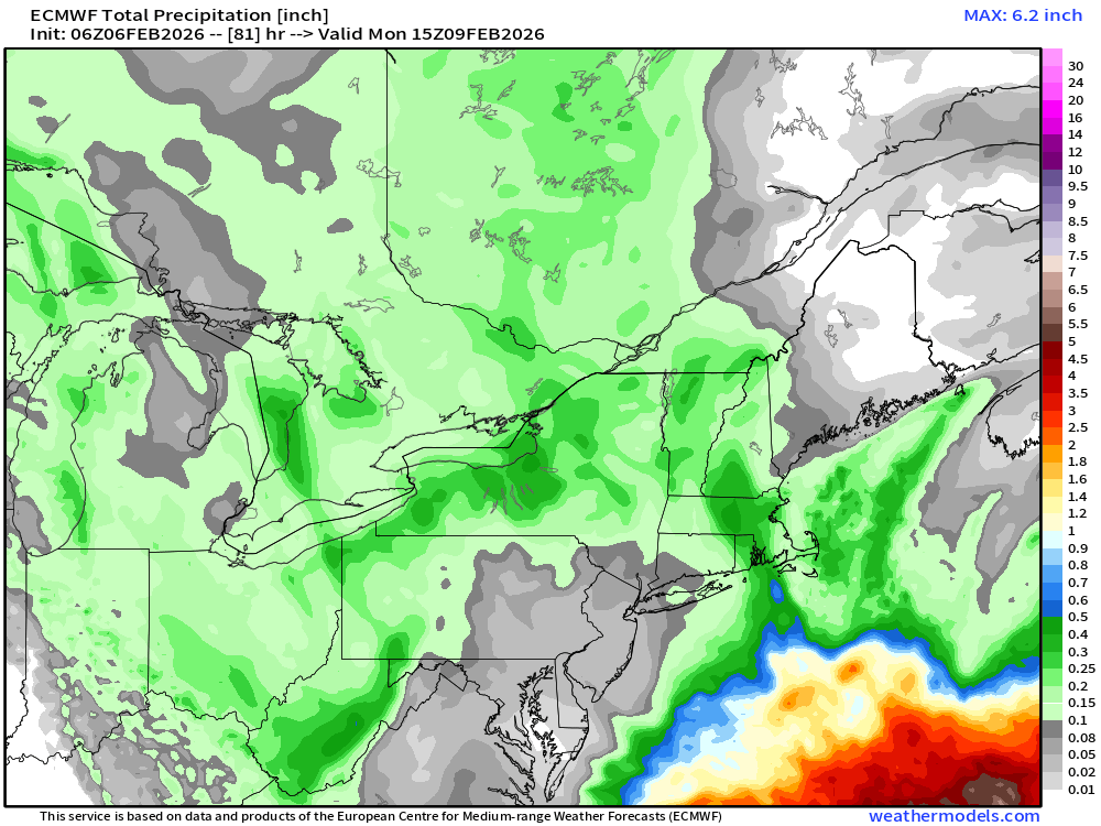
-

2025-2026 ENSO
michsnowfreak replied to 40/70 Benchmark's topic in Weather Forecasting and Discussion
Wow thanks for posting this. I knew it was cold but didn't realize the impressive nature of it. @bluewave frequently mentions that cold anamolies are short in duration. This is the opposite. January 15 - February 4 is the coldest 3 weeks of the year on avg to begin with. 2026 now ranks 3rd coldest for that 3 week stretch at Detroit in 153 years of record. Only 1918 & 1963 were colder. Pittsburgh also ranks 3rd in 152 years of record. Cleveland 4th in 156 years. Toledo 6th in 153 years. And even NYC 17th in 158 years. @FPizz @mitchnick @MJO812 -
Looks like a quick hitter for S.SNE for mid week and that’s about it. The weekend threat is gone
-
21 here and cloudy
-

February 2026 Medium/ Long Range Discussion: 150K Salary Needed to Post
CAPE replied to Weather Will's topic in Mid Atlantic
Still liking this window a lot right now, but way out there. -
 Lack of post here about cold surprising or telling? Extreme cold warning for all of CT.
 -

Friday February 6 FROPA / WINDEX small event
CoastalWx replied to HoarfrostHubb's topic in New England
Snow will blow into every crevasse and look like nothing fell. -
Friday February 6 FROPA / WINDEX small event
dendrite replied to HoarfrostHubb's topic in New England
I don’t think there will be much wind until the fropa. -
February 2026 Medium/ Long Range Discussion: 150K Salary Needed to Post
CAPE replied to Weather Will's topic in Mid Atlantic
The shortwave of interest for next weekend weakens in the convergence behind the NS energy on the ens means similar to the op runs. As we know, models rarely(never) have the location and timing of these wave interactions nailed a week out. Plenty of time for corrections. -
Storm isn’t for 5 days…it’s gonna be all over the place…just another run.
-
Top 10 cold period past two and a half weeks for eastern US: https://x.com/wxjerdman/status/2019729810914992195
-

Friday February 6 FROPA / WINDEX small event
WinterWolf replied to HoarfrostHubb's topic in New England
Lol…but all the snow from west of here will blow to us…it’s all relative. -

Is we back? February discussion thread
Damage In Tolland replied to mahk_webstah's topic in New England
-
Friday February 6 FROPA / WINDEX small event
Damage In Tolland replied to HoarfrostHubb's topic in New England
We could see all your snow OTG blown EOR -
13 here. Popular number the last couple mornings. Hoping for an inch or two with the upcoming snow but models seem to be shifting east with it more.