All Activity
- Past hour
-

January 2026 regional war/obs/disco thread
Typhoon Tip replied to Baroclinic Zone's topic in New England
The GEFs version above looks like a bit of an undercutting/split flow... -

E PA/NJ/DE Winter 2025-26 Obs/Discussion
penndotguy replied to LVblizzard's topic in Philadelphia Region
Meh, give it 24 hrs and it’ll show something different. -

January 2026 regional war/obs/disco thread
weatherwiz replied to Baroclinic Zone's topic in New England
It's definitely an extremely intriguing look and what I like about it is this type of pattern opens the door for some southern stream involvement and that would at least offer some potential for a bigger storm. But why I also love the Jan 10-15 period is we may see a relaxing NAO during that period, or the NAO becoming less negative and at the same time we're seeing variations within the state of the PNA. The pattern will not be void of energy and storm chances. If we want to add another layer to this is we will have the PV displaced on our side of the hemisphere. -

New Years Day 2026 - 1st snows of the new year possible
Damage In Tolland replied to Baroclinic Zone's topic in New England
It’s very easy to look at literally every model and see steady light snow shown on all of them . All for a 1-4” event from west to east. Not rocket science -

Winter 2025-26 Short Range Discussion
sbnwx85 replied to SchaumburgStormer's topic in Lakes/Ohio Valley
3-6" over two days, but it'll be so fluffy it'll compact to 2" real quick. -
At least half of that is 1/1, although I'd be happy with a fresh coating each day...
-

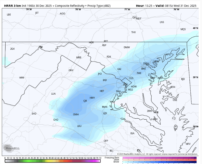
12/31-1/1 Possible Snow Showers/Squalls to Start 2026
WxUSAF replied to bncho's topic in Mid Atlantic
Looks like a top 3 snow event of the season for MBY! -

Central PA Winter 25/26 Discussion and Obs
GrandmasterB replied to MAG5035's topic in Upstate New York/Pennsylvania
“Here's a BIG reason to be skeptical of a monster snowstorm in the mid-Atlantic States through mid-Jan…” -MU Incredibly bold call to predict no “monster” snowstorms in the next two to three weeks. -

12/31-1/1 Possible Snow Showers/Squalls to Start 2026
IronTy replied to bncho's topic in Mid Atlantic
I'm hoping for a dusting so I can't get to work tomorrow since I'm supposed to go onsite. -

January 2026 regional war/obs/disco thread
TauntonBlizzard2013 replied to Baroclinic Zone's topic in New England
Hey. Positive vibes only I guess. It snows in people’s hopes and dreams, rarely in reality and on the models, where it actually matters,over the last half decade or so -

New Years Day 2026 - 1st snows of the new year possible
dryslot replied to Baroclinic Zone's topic in New England
18z Nam really blows this low up towards DE Maine down to 987mb dropping a foot there, May watch this to see if this can happen a bit sooner in the next 24hrs, That would at least get some accumulating snow further west but as of now, Its a bit to late for most, Nothing else better to do.........lol -
January 2026 regional war/obs/disco thread
Typhoon Tip replied to Baroclinic Zone's topic in New England
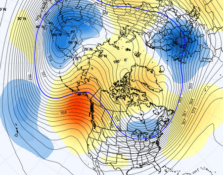
right ... the veneer of this is pretty. 360+ hours ... obviously low skill so whatever. But this isn't first time we've seen this, this winter season so far. These ranges of the ensemble means don't typically have coherent pattern signals. I mean, I've seen less clear pattern implications on a D7 ranged charts plenty of times over the years... Usually, at this extended range, the flow looks annular about the N. Pole, almost equidistant. You know ...circular. It's the mean of the noise, of all ensemble members wondering off on daydreams over time. This below, this intrinsically means that the vast majority of them have a hard on for a -EPO at a range where they pretty much never have a clue - and really aren't supposed to. Unless there's been some sort to techno breakthrough I'm less privy to, I've never seen this before like I am seeing specifically this winter thus far at 360+ hrs. Can ens EPS GEFS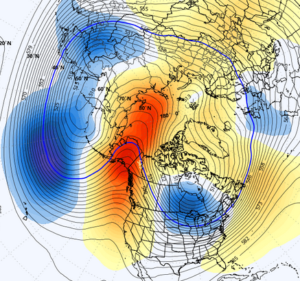

-
Hair dryer should clean it all up.
-
New Years Day 2026 - 1st snows of the new year possible
TauntonBlizzard2013 replied to Baroclinic Zone's topic in New England
I also wouldn’t be expecting much outside of the previously highlighted areas. It’s a moisture starved clipper. The accumulation Hope is on some form of redevelopment. People are deluding themselves if they think this is going to drop a widespread inch or two -
Made it to the Tug. About 2’ otg with about 45” forecast. We are northeast of Pulaski. Anyone who gets a wild hair and wants to attempt a chase, this is a big ol cabin with tons of room. LFG!!
-

12/31-1/1 Possible Snow Showers/Squalls to Start 2026
bncho replied to bncho's topic in Mid Atlantic
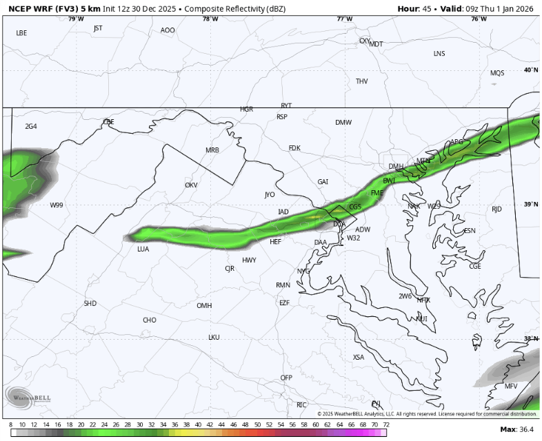
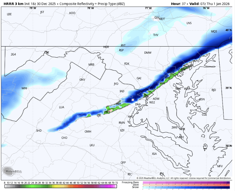
That's more than okay with me. NAM and HRRR have snow falling but whether it actually hits the ground is questionable,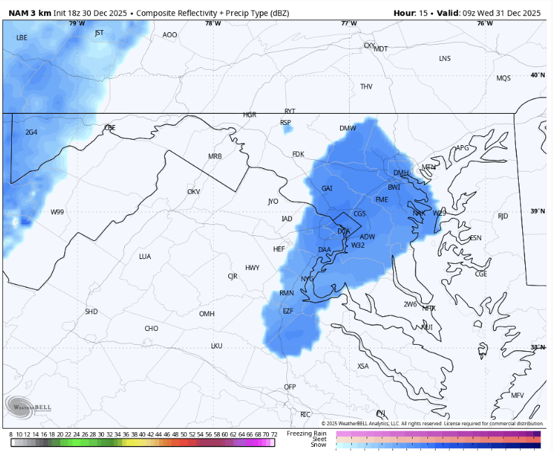
-
Central PA Winter 25/26 Discussion and Obs
GrandmasterB replied to MAG5035's topic in Upstate New York/Pennsylvania
I don’t need a Met to tell me the odds of a big snowstorm are low. Of course they are. It’s relatively rare to get a double digit snowfall around here. Seems like he’s simply playing the percentages and then gloating about it. -
-

January 2026 regional war/obs/disco thread
RUNNAWAYICEBERG replied to Baroclinic Zone's topic in New England
Why can’t we bet on weather? Cmon Vegas… -

12/31-1/1 Possible Snow Showers/Squalls to Start 2026
NorthArlington101 replied to bncho's topic in Mid Atlantic
If this threat also includes the 2 flakes to a dusting we might get tonight I’m all for it -
We should all take a break from the LR thread and track something in the short-range that might as well be nothing. If the mods wanna remove the thread above then they are free to do so.
-
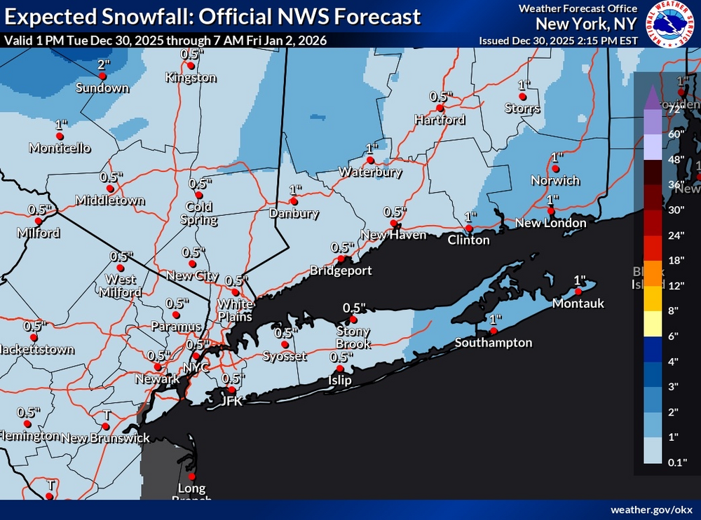
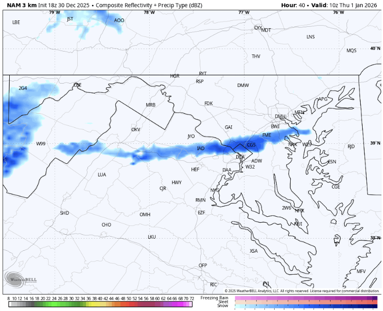
I thought I would create this thread to give people a break from the doom and gloomy mess that the LR thread is. At least we have a chance to get on the board for January until the good pattern later that month. It's something to track so who cares. FWIW 18z HRRR and 12z FV3 are on board with something. 18z NAM not as much but still there. Edit: You can also include tonight's possible dusting in here as well. 100% for it.
-
That Twitter met knows his stuff. He predicts that mid-late January has the best chance for wintry weather. (Checks earth annual orbital procession)...bold call.
-
Central PA Winter 25/26 Discussion and Obs
GrandmasterB replied to MAG5035's topic in Upstate New York/Pennsylvania
MU vs. Eric Webb battle on X -

New Years Day 2026 - 1st snows of the new year possible
Hazey replied to Baroclinic Zone's topic in New England
Yup still here. I’m watching but have had the rug pulled on me too many times to get excited. Need another day of model runs. Could be the critter that bites.


.thumb.JPG.418e8a9a2902ae687ec35ff4bc0e038e.JPG)


