All Activity
- Past hour
-

September 2025 OBS-Discussion centered NYC subforum
donsutherland1 replied to wdrag's topic in New York City Metro
As of 4:30 pm, some showers were working their way into southern New Jersey. Cape May was receiving light rain. Some of these showers could each the New York City area tonight. Showers and light rain are possible tonight into tomorrow. Rainfall amounts should be light. Above normal temperatures will continue through the remainder of September. The start of October could see the arrival of the coolest air mass so far this season, but temperatures will likely quickly moderate. The guidance and historical experience following a second half September mean temperature of 70° or above suggest that October will be warmer than normal in the New York City area. The two most recent Octobers with a cooler than normal first half like 2025 and a second half with a mean temperature of 70° or above were: 2017 (October mean temperature: 64.1° and October 2019: October mean temperature 59.9°). The probability that TD9 will approach the South Carolina coast but then turn out to sea from there is increasing on account of the expected Fujiwhara interaction with the stronger Humberto. That is now the most likely outcome, even as there remains a possibility of landfall. Even without landfall, the storm would bring periods of heavy rain, gusty winds, and pounding surf to coastal areas. The ENSO Region 1+2 anomaly was 0.0°C and the Region 3.4 anomaly was -0.4°C for the week centered around September 17. For the past six weeks, the ENSO Region 1+2 anomaly has averaged -0.03°C and the ENSO Region 3.4 anomaly has averaged -0.38°C. La Niña conditions will likely develop during mid- or late-autumn. The SOI was +2.85 today. The preliminary Arctic Oscillation (AO) was +0.807 today. Based on sensitivity analysis applied to the latest guidance, there is an implied near 99% probability that New York City will have a warmer than normal September (1991-2020 normal). September will likely finish with a mean temperature near 70.3° (1.1° above normal). Supplemental Information: The projected mean would be 2.3° above the 1981-2010 normal monthly value. -
Doesn’t look like rain anywhere next 2 weeks
-
Yes, Capatain made comment about the Natives using it for arrowheads, axes, etc Sent from my SM-S921U using Tapatalk
-
The hrrr hated this storm and the euro loved it too much . Bust
-
Getting some light rain here. Better stuff to the s/se. Hopefully some of the heavier showers will shift a bit NW over the next couple hours.
-
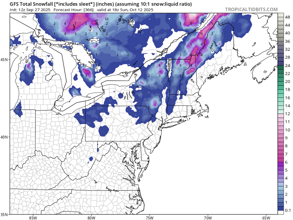
W MA through CNE may be able to fire up some more drought talk next week. Does not look real wet over the next 10 days.
-
They are less allergenic than other pines.
-
This has transcended previous niñas though, there has not been a prolonged wet pattern since 2022. Every opportunity since then to end the overarching pattern has either resulted in it paradoxically intensifying (spring 2023 and last spring) or relatively short reprieves that end with it roaring back (this past June and July). Question is will the end of this niña finally open the floodgates or did the triple dip niña shift the atmosphere some more and now this is permanent for us?
-

September 2025 OBS-Discussion centered NYC subforum
SACRUS replied to wdrag's topic in New York City Metro
-
Short answer is La Niña. Second answer is it’s still the warm season.
-

September 2025 OBS-Discussion centered NYC subforum
Sundog replied to wdrag's topic in New York City Metro
Rain cancel -
Quite the chunk of chert. Some of that stuff has been found in ancient indigenous settlements west of the Great Lakes, as it was great for fire starting.
-
-
Why is it that we need to have the planets align in order for that to happen? It is not supposed to be this hard to get decent rains around here.
-
Radar looks like crap. Really ready for a day of a uniform precip shield.
-
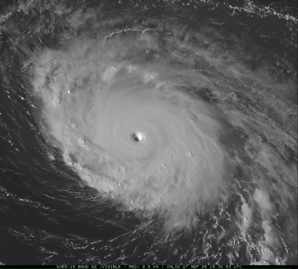
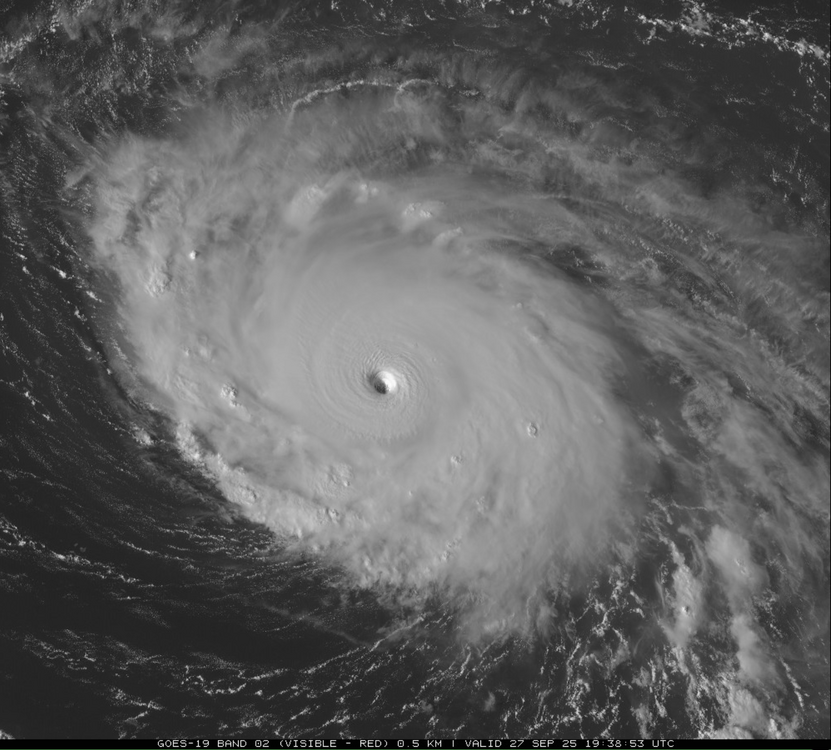
What a beast. What a week. Atlantic showing off finally
-
Seriously gorgeous fish food this year.
- Today
-
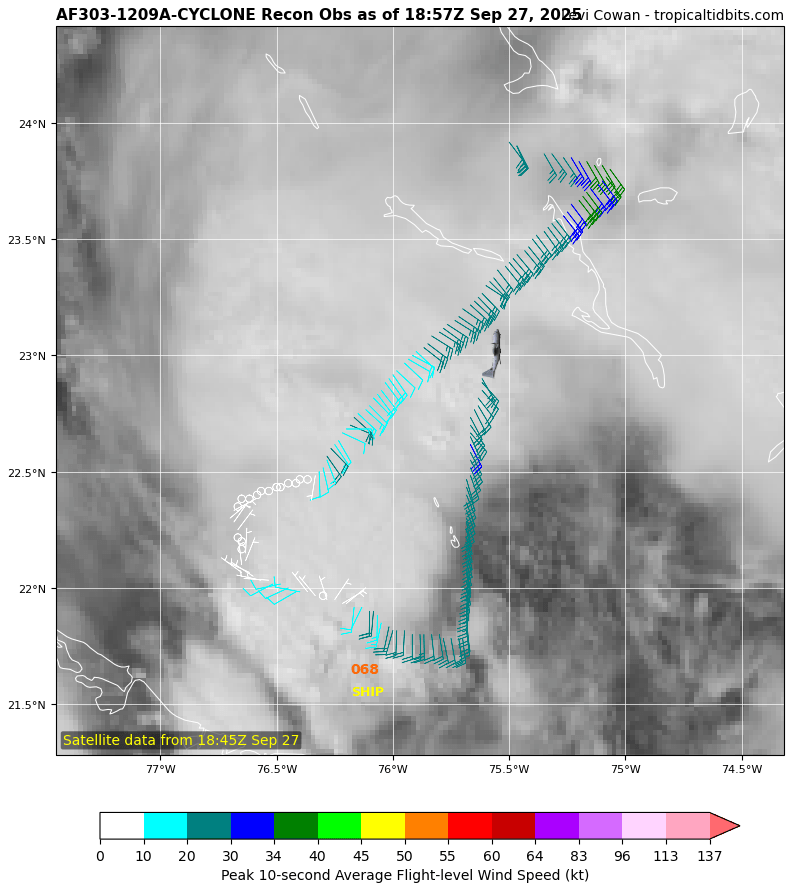
Nice visible loop. https://www.meteo.psu.edu/ewall/PSUGOES_MESO2/loop60.html
-
If this busts it's really gonna hurt, and I'm guessing there's 0 chance for the models to do a 180 on the Imelda walk backs?
-
Need as much rain from this event as possible because that’s one helluva block setting up afterwards. Those tropical systems have no chance here with that monster moving in. Looks like an extended period of nice weather coming up.
-
It's amazing how much Imelda's rain for the MA is following the same rug pull pattern as the Feb. 19-20 incident...
-
The stadium effect is incredible. Looks like a West Pac super Typhoon.
-
Starting to see some strong cold fronts coming into the lower 48 especially on the Euro.
-
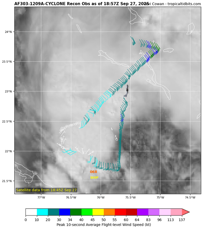
Not sure it's a tropical cyclone anymore lol. Where did the center go?


.thumb.png.4150b06c63a21f61052e47a612bf1818.png)