All Activity
- Past hour
-
 This was the final haul today . It’s a shame because there’s tiny ones growing and new flowers https://imgur.com/a/h7twWnX#9Hy3Wwc
 -
That’s my baby son’s due date…
-
You should align your position with the consilience of evidence. The consilience of evidence is contrary to what Lindzen and Happer say. For example... Lindzen says that the Earth has an adaptive iris effect that causes more light to reflect back to space as the planet warms and that will result in little to no warming of the planet overall. And yet here we are with a warming planet and a declining albedo. That's a double whammy for Lindzen's model. Other models like those proposed by [Manabe & Wetherald 1967] long before the psuedoskeptics made their appearance say that the planet will warm and will do so with an amplifying effect as a result of a lowering of albedo. Lindzen talks a big game with an academic style delivery that seems to command authority, but no one uses his models because they don't work in the real world. Mainstream models built upon the consilience of evidence may not be perfect, but at least they actually work. Happer says that the CO2 effect is saturated. But every radiative transfer model in use today says the opposite. The RRTM is one such model that is widely used in global circulation models forecasting high impact weather events in which people's lives are literally at stake. The RRTM is a core module among the physics modules that run within GCMs like the GFS and ECMWF which would be nearly useless without it. The RRTM is also used to design and build space based radiometers for observational meteorology like the ABI onboard the GOES-R satellites. The RRTM says that the effective radiative force of CO2 at 800 ppm is roughly +4 W.m-2 as compared to if CO2 is at 400 ppm. Happer talks a big game with an academic style delivery that seems to command authority, but no one uses his models because they don't work in the real world. Mainstream models built upon the consilience of evidence may not be perfect, but at least they actually work.
-

November 2025 general discussions and probable topic derailings ...
powderfreak replied to Typhoon Tip's topic in New England
Thought we had first high in the 30s today down in the valley, but alas looks like we snuck a 40F in there somewhere. Base of ski area never got above 36F with 2-3” of snow cover. Cold day, and getting some flurries now. -
My parents live in Norwell, I live in Concord (MA) - was visiting there last week. Crazy difference.
-
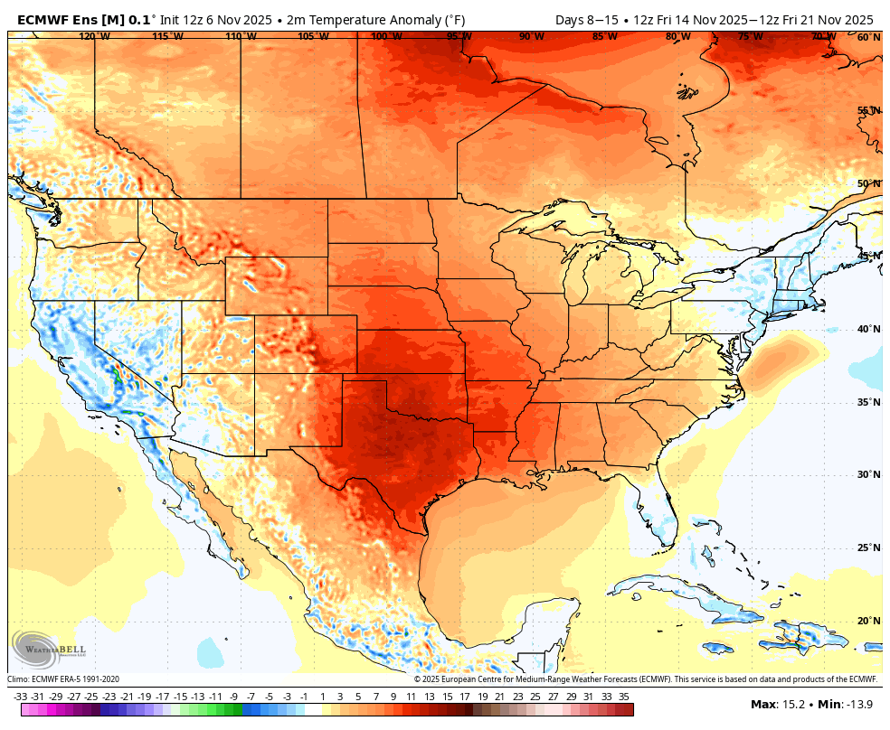
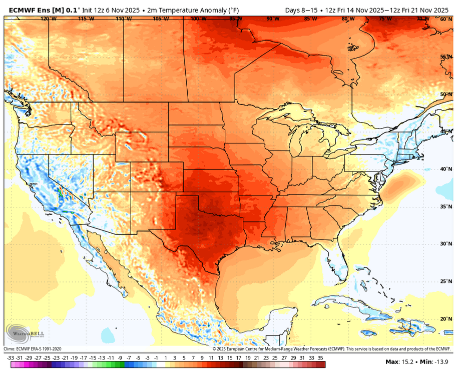
GFS Ens and ECMWF Ens both agree with a rather warm look across the conus, with the exception the our region and the NE part of the country, during days 8 to 16. The warm up is most pronouced in the center of the country. Canada also warms a bit.
-
Latest GFS run stunk pretty bad, worse than 12z for the mountains as it had a less amplified and less deep trough.
-
Think Dendy was correct. Growing season should end here tonight. Was a great 6 months .
-
We need to restart that early Dec snow heater. Been too long.
-
-
Such a beautiful part of the country. Saranac Lake and surrounding areas are a great vacation spot. It would be fun to take one of these small airlines up there.
-
Could you imagine if we got a legit Dec 5th event? Something like a regionwide 3" - 5" fluff storm? This place would crash from excitement.
-
Its lazy. They roll that shit out every Fall.
-
This run backed off on Amounts. We'll see if that's a trend by 0z. I'd expect it to uptick as Lakes are very warm so plenty Upslope to be fed.
-
Someone's excited! Glad we're back in the hunt though we are likely chasing token first flakes at best
-

Best Mid-Atlantic winter storm of the last 50 years
Eskimo Joe replied to PrinceFrederickWx's topic in Mid Atlantic
For me it's a toss up between PD II (Feb 2003) and December 2009. Both events I experienced in Philadelphia and Lancaster County, PA respectively. PD II: I was in high school in Philly just got into winter weather tracking and had access to the Internet at my high school library for the last period of the day. The librarian was always gracious enough to let me just quietly geek out on model guidance and NWS web pages. Watching this storm get more and more interesting as we closed on the end of the work week was awesome. December 2009: I was working 2nd into 3rd shift at the IT Help Desk at Millersville University and got paid to do homework and watch both the 18z and 00z model guidance come in on a triple monitor display with a nice Internet connection. I was also was a lead forecaster for our campus weather service at the time, and we had access to a read-only version of NWS chat. It was just pure giddiness to watch the 1.5" QPF line creep north with each model cycle, reach the AFDs from LWX/CTP/PHI and see the inklings of watches or warning start to come up in the chat rooms. I felt like I had access to almost secret data and it was AMAZING! Then came the morning before the event and I knew it was going to puke snow all along Mason-Dixon. It was the end of my undergraduate years and I was supposed to walk in graduation on the 19th, but I knew that wasn't going to happen. So I rushed back to Philly and boom...White Christmas. -
Lets build that snowpack up north
-
LOL that's boilerplate climo. Lazy af. It's what most of these local mets do every Fall. How many times has that worked out east of the mountains since 2016? Hint- coastal areas have gotten above normal snow more times than not- that's well more than 0-6 lol.
-
Don’t like how warm Canada is but for now no panic
-
 Looks like just enough troughiness in the East to keep us around normal to slightly below, while most of the country is well above normal..
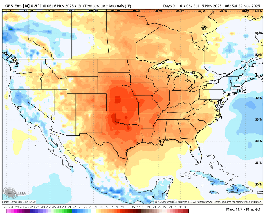

-

Mid to long range discussion- 2025
WinstonSalemArlington replied to wncsnow's topic in Southeastern States
- Today
-
Nice pattern coming up for the higher elevations and the Great Lakes snow belts.

-
We’ve been past peak for 2 weeks, almost all leaves down. Crazy the ranges we get in this forum.
-
Mid to long range discussion- 2025
WinstonSalemArlington replied to wncsnow's topic in Southeastern States
-

2025-2026 ENSO
PhiEaglesfan712 replied to 40/70 Benchmark's topic in Weather Forecasting and Discussion
And don't forget that we also got the volcanic cooling from Pinatubo, which helped fueled the snowy winters of 92-93, 93-94, and 95-96. Then again, it's highly unlikely we're going to get something like Pinatubo the rest of this decade. So, we're going to have to hope this next el nino flips the PDO positive or the Pacific jet becomes slow again (like 2009-10/2010-11 or 2013-14/2014-15). Are you sure the PDO is -1.31? I see -2.40 as the value for October 2025 (actually lower than the -2.33 in September) on NOAA: https://www.ncei.noaa.gov/pub/data/cmb/ersst/v5/index/ersst.v5.pdo.dat