All Activity
- Past hour
-
mby snuck in on the warning, i'll count it but not expecting much here other than a low end shelf
-
Heather Hill is example one. Essentially dirt.
-
Maple gate is going to be a solar farm. They sold it for 24 million. That would be a lot of green fees
-
Not at home today :-/
-
prayers 4 king james
-
Latest radar scans seem like the line is accelerating. Derecho anyone?
-
 Maple Trust Rx: canadian pharmacy tampa - Maple Trust Rx
 -
the images of the mega drought in europe right now have me counting our blessings and hoping the current trends lock in as the all-time super nino flexes into the cold season
-

Augdewst 2026: Summer's Last Stand
Typhoon Tip replied to Prismshine Productions's topic in New England
I'm not so sure that's wrong looking at the overnight ... very light NW drift is ideally moving a high heat content source right at Logan: that being Boston's urban asshole. This was probably going to be a warm urban/cooler subburb deal overnight. HFD there was 65... ORH AP a 1000 feet above the decoupled slab of false autumn was also 65, somewhat also evince that. Boston being the biggest urban warm pig on the map with a NW to NNW gentle stenchy city fart all night might just have elevated that site anthropomorphically Also, interestingly ... the Harbor is torched. 70 F SSTs. Not sure what this compares to normal but I suspect it is warm? -
Just got a juicer last week. Nothing better than a fresh glass of beet, apple, cucumber, lemon, ginger juice to wake you up. :-)
-

Mountain West Discussion
mayjawintastawm replied to mayjawintastawm's topic in Central/Western States
And today it's almost back up to where it was on Monday. Guess it shows how hard it is to model these kinds of things. Could be a good opportunity to learn something? -
https://trustpharmaindia.com/# reputable indian online pharmacy
-
I'm glad we got a bit of pre-soaking in last week before this Howitzer train hit. If it would've hit at the beginning of the month when my ground was so dry it was Bonneville lake bed cracking all of that juice would've ran straight for the creeks and rivers. Ground is setup to do some aquifer regeneration. It really shows out here in rural areas where with as much rain as we've gotten this week it's been soaking in fast. We're saturated now, need a break to drain lol.
-
You folks in Indiana doing alright? The rain there looks incredible at the moment.
-

Augdewst 2026: Summer's Last Stand
weatherwiz replied to Prismshine Productions's topic in New England
Might be a decent light show tonight SOP -

2026 Atlantic Hurricane Season
NorthHillsWx replied to Stormchaserchuck1's topic in Tropical Headquarters
93L likely became a brief tropical storm overnight based on the LLC seen on visible this morning but since that time convection has been ripped well to east of center. Might be a numbers booster in post season analysis -
More storms coming through this afternoon.
-
il fixing to stat pad with some more spinups? at this point it's taking the all-time record from tx or bust
-
Unreliable Heat Index?
-

2026-2027 Record-breaking El Nino
GaWx replied to Stormchaserchuck1's topic in Weather Forecasting and Discussion
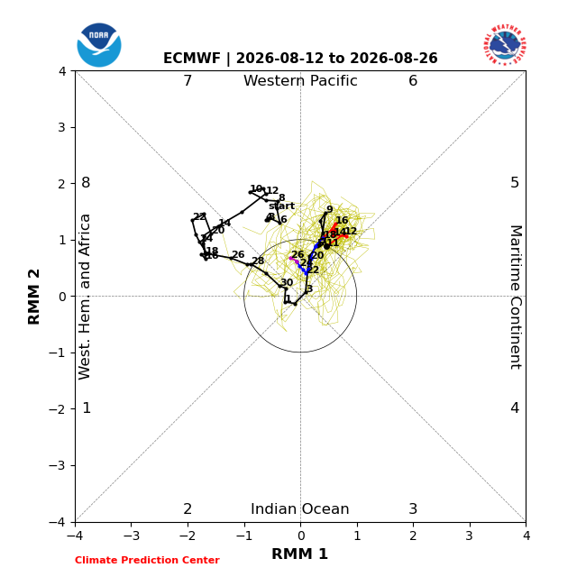
There’s a decent chance for a record breaking long phase 6 this month. It started in phase 6 on Aug. 3rd: The latest GEFS, one of the more reliable for the MJO in the WPAC, has phase 6 through the entire run, Aug 26th, except it has it on the border of phase 5 Aug 18-20th: The EPS has it in phase 6 through 8/23: These are the longest phase 6 periods on record (back to late 1974): 6/13-30/1984 18 days 7/28-8/18/1984 22 10/6-20/1988 15 7/15-8/4/1996 21 2/25-3/10/1997 14 11/16-12/1/1998 16 7/19-8/1/2018 14 10/13-31/2022 19 1/5-21/2026 17 So, the longest phase 6 is currently the 22 days of late July-Aug of 1984 with the 2nd longest of 21 days mid July-early Aug 1996 (both near same time of year). The GEFS is suggesting the current one could reach 24+ days while the EPS has it ending up at 21 days.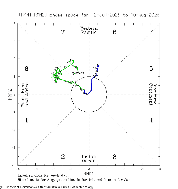
-
I may get clipped or may miss this mcs by a few miles. Will be real close
-

Augdewst 2026: Summer's Last Stand
CoastalWx replied to Prismshine Productions's topic in New England
We UHI -
hrrr rather insistent on training cyclone following another mcs out of iowa tomorrow droughtville to flood headlines can sure hit you fast in the modern era
-
Consistent miss south for Madison and points north in southern Wisconsin, as well. Naturally Wausau area managed a few severe storms late last night despite being well north of even the marginal risk contour.
- Today
-
Looks like I-90 on south, roughly.